FLORIDA WRECK ON AERIALS 4U2C

gldhntr

Bronze Member
Dec 6, 2004
1,382
79
can't figure out how to get to link of the photo but you can go to http://local.live.com/
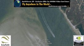
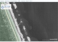
type in '' north peninsula state recreation area'' click on aerials,, when the pic comes up put it on 150 yard zoom....on the lower right of the park you will see the A1A designation for the road...put this little block with A1A just in picture below the word welcome above the pic....now look in the middle of the pic, directly below the word share above picture....you will see an outline of a large wreck sloping down and to the right...........gldhntr
 

ScubaFinder

Bronze Member
Jul 11, 2006
2,220
528
Tampa, FL
Detector(s) used
AquaPulse AQ1B - AquaPulse DX-200 Magnetometer
Primary Interest:
Shipwrecks
I found the location, but I don't see a wreck...what am I missing?
 

Attachments

  • wreck.jpg
    wreck.jpg
    39.4 KB · Views: 570

mad4wrecks

Bronze Member
Dec 20, 2004
2,263
107
Detector(s) used
Aquapulse, DetectorPro Headhunter, Fisher F75
Primary Interest:
Shipwrecks
Wisteria Island, Key West

Don't know how old these wrecks are but they look cool from the air.
 

Attachments

  • wreckswisteriaislkeywest.jpg
    wreckswisteriaislkeywest.jpg
    38.5 KB · Views: 573
OP
OP
G

gldhntr

Bronze Member
Dec 6, 2004
1,382
79
scuba seeker,,, scroll your map down till the A1A symbol is directly under the word welcome at top of pic...the bottom right corner of the green area designating park will be about 2 inches up from bottom of page......g
 

ScubaFinder

Bronze Member
Jul 11, 2006
2,220
528
Tampa, FL
Detector(s) used
AquaPulse AQ1B - AquaPulse DX-200 Magnetometer
Primary Interest:
Shipwrecks
In case you didn't notice, the A1A marker IS directly under the word Welcome :D I'm missing something.

Jason
 

OP
OP
G

gldhntr

Bronze Member
Dec 6, 2004
1,382
79
no i didn't notice....must be the difference in monitor size......here is the link to pic...if it still doesnt show scroll down till you see the bottom right corner of the green park area....draw an imaginary line straight across your monitor screen under and touching the bottom of the D in the word blvd....this line will be just above and almost touching the outline of the end of the wreck, which slopes down and to the right from this point........ http://local.live.com/default.aspx?v=2&cp=29.413774~-81.093929&style=h&lvl=17 ..........
 

rgecy

Bronze Member
Jun 14, 2004
1,910
59
Beaufort, SC
Detector(s) used
Garrett Sea Hunter Mk II
I SEE What you are looking at! I think it is just some dark pixels and a combination of silt in the current. But I could be wrong! It is so hard to tell at that resolution and with the water being cloudy! Maybe if we could find another image of the same area with better clarity and resolution and see if there is something in it as well.

Robert in SC
 

pcolaboy

Hero Member
Sep 5, 2006
916
14
Pensacola, Fl
Detector(s) used
Minelab Explorer XS
A good technique for analyzing aerial photos from Google Earth, World Wind, or others is to save the image to a file such as a .JPG or whatever the native type is. Open the image file using photo editing software such as Microsoft Photo Editor, or even plain old Microsoft Paint. You can then choose the option to create a 'negative' of the image. This works suprising well to determine if an object that you see is indeed an object rather than a shadow or mud, etc. etc.

So far in only 3 months of trying, I have located 9 uncharted wrecks as well as several other man made features that color photos never revealed.

Pcolaboy
 

FISHEYE

Bronze Member
Feb 27, 2004
2,333
400
lake mary florida
Detector(s) used
Chasing Dory ROV,Swellpro Splash 2 pro waterproof drone,Swellpro Spry+ wa,Wesmar SHD700SS Side Scan Sonar,U/W Mac 1 Turbo Aquasound by American Electronics,Fisher 1280x,Aquasound UW md,Aqua pulse AQ1B
Primary Interest:
All Treasure Hunting
I found this possible wreck with keyhole a few years ago.at low tide you can walk there,high tide the water is 2-4 feet deep.you can see the impression of a boat like structure in the sand,has a square stern.pointy bow,almost like a galleon.
 

Attachments

  • place.jpg
    place.jpg
    35.4 KB · Views: 453

macblastr

Jr. Member
Oct 17, 2006
68
3
Central Florida
Detector(s) used
excalibur 1000, 1280x, impulse
anyone get bored enough to look through all the post hurricane jeanne NOAA low altitude photos? here is a link... i did alittle looking and saw some interesting possibilites. its from melbourne to palm beach... beatiful photos, super hi def.

http://ngs.woc.noaa.gov/jeanne/JEANNE0000.HTM

they also have photos of post katrina and other major hurricanes - but i live on the east coast of FL, and it seems alot of the forum people do too! check it out!!!
 

Top Member Reactions

Users who are viewing this thread

Top