1641 Plate Fleet information

Fester

Tenderfoot
Apr 18, 2012
5
1
Primary Interest:
All Treasure Hunting
Don't know if it helps, but I've read on another site... NORTHEAST FLORIDA SITES that there is a dangerous shallow shoal, north of St. Augustine, at the mouth of the st. mary's river called pelican shoal. Apparently some believe there have been as many as 11 ship wrecks on this shoal. According to the site above in particular this is a very seldomly visited or thought of place to look. I'm thinking of checking it out some times this summer if all bodes well. Probably start with a snorkeling trip out from fernandina, see if my dad is up for taking his sail boat out and checking it out. This could be a possibility for some, but I'm a little unsure since one account listed here called for them being stuck against a cliff. I'm almost certain there is no where in florida that has a cliff on the shoreline, that seems maybe one of the islands to the south or as mentioned before here further north maybe up the georgia or carolina coast.

But here is my thinking. I would reckon, that if I'm captain of a spanish ship out from havana headed back home to spain, with my belly full of gems, gold and silver, this would be my plan. Sail east northeast, along the keys safely in a channel, but within safe distance of land as they knew they set sail during hurricane season. I would personally stay close to the shore for a good ways north. This gives safe harbor for storms, and if needed for a repair. Also for fetching of fresh water and food if needed. Also they could resupply at familiar outposts as the headed north along the coast, cape canaveral, st. augustine, fernandina, fort caroline in south carolina. Then make the turn right out into open waters towards either bermuda, or even the azores before going back to spain.

I'm trying to do some research now to see if I can conclude any of this to be true or not. I'm just thinking Spain is awful far north to head northeast from the bahama canal into opean ocean with all the loot. If anyone knows more about the route they took home it would be a great help.
 

OP
OP
H

hobbit

Sr. Member
Oct 1, 2010
304
110
I think Pelican Spit is a GREAT place to start looking. I have heard rumors for years that Spanish Coins have been found on Jekyll Island which is just north of Pelican Spit. It is actully around 16 miles north of the St. Marys, just north of Cumberland Island. There are lots of "seldom visited or thought of places to look" on the Georgia coast, IMHO. In regards the "cliff", something may be amiss with the translation, although I know of several places north of the St. Marys where there are large, eroded dunes close to shore with "cliff like" faces. Barrier Islands are subject to immense erosion, of course, so much may have changed since 1641. In regards to an navigator "hugging the coast", I am not sure. I think that once clear of Cape Canaveral, he would have wanted to get back into the gulf stream as quickly as possible, out to at least 80 deg. west. and then maybe head NNE following the stream. There is much disagreement about the actual routes the fleets took back to Spain once clear of Canaveral, especially early ones. I think it is safe to say that no one knows for sure.
Don't let the "cliff" thing dissuade you from seriously checking out Pelican Spit!!! Check out Jekyll, too!!!
"Jekyll Island is one of only four Georgia barrier islands that feature a paved causeway to access the island by car. The island is 7 miles long by 1.5 miles wide, has 8 miles of wide, flat beaches, and boasts 22 miles of hiking trails."

Only four Georgia barrier islands have paved causeway access...what does that tell you about the nature of the coast?
 

Last edited:

Diver_Down

Silver Member
Dec 13, 2008
4,373
2,000
St. Augustine, FL
If you are looking at Jekyll or Cumberland, then you should also know that metal detecting is not allowed on either. Jekyll is a state park and Cumberland is a National Seashore.
 

OP
OP
H

hobbit

Sr. Member
Oct 1, 2010
304
110
If you are looking at Jekyll or Cumberland, then you should also know that metal detecting is not allowed on either. Jekyll is a state park and Cumberland is a National Seashore.

There are certainly some issues regarding the legality of using metal detectors on some of the islands in the area, Cumberland and Jekyll included. In regards federal park lands ( which include national seashores ), if you don't have a boat:


"Title 36 of the Code of Federal Regulations Section 2.1 (a) (7) prohibits the use or possession of metal detectors, magnetometers, and similar equipment within the jurisdiction of national park lands. However, such devices may be transported through park areas provided they are broken down, dismantled, and cased in such a way that prevents their ready use."


This brings up the thorny issue of submerged lands jurisdiction. I am not suggesting anyone do anything "illegal", but as a practical matter, If you are in the water and are discrete, you might be O.K.

I have detected in the water around Jekyll and not had a problem. At low tide you can stand in chest deep water a mile off shore...
 

Last edited:

Diver_Down

Silver Member
Dec 13, 2008
4,373
2,000
St. Augustine, FL
Something has been eating at me regarding The Cliff. On Little Talbot Island (south end), is an area called The Bluffs. The south end also comprises the norther border of Fort George Inlet. Vessels could have been looking to take shelter from the storm ...
 

OP
OP
H

hobbit

Sr. Member
Oct 1, 2010
304
110
Something has been eating at me regarding The Cliff. On Little Talbot Island (south end), is an area called The Bluffs. The south end also comprises the norther border of Fort George Inlet. Vessels could have been looking to take shelter from the storm ...

It is possible, no doubt, but I can't get over the fact that there is no mention of the hurricane or any attempted salvage of the wrecks in what we know of the history of St. Augustine...also, Concepcion and apparently two other vessels actually sailed east of the Bahamas and got back to Hispaniola and Cuba, Concepcion under such a jury rig that it took her over a month before she grounded in what is now the DR...I don't know if I can see them doing this if they grounded that close to St. Augustine...but, of course, anything is possible...
 

Chagy

Bronze Member
Dec 20, 2005
2,226
121
Florida
Detector(s) used
JW Fishers Pulse 8X
Primary Interest:
Shipwrecks
hobbit, the location of these wreck its still a mystery even to some of the best researchers and well known treasure hunters. I my self have been studding them for many years. I believe you have come closer than most of us. you will not find any salvage attempts because there were non. As you well know Burt Webber was the one who discovered the Concepcion with the help of researcher Jack Haskins and at the end Eugene Lyon hit the nail on the head by finding the log of the Henry in England. How ever Burt and Jack new there was valuable cargo on the rest of the fleet and since they had already done the research on the Concepcion, if some one had any information on the rest of the fleet was them. Burt is a very good personal friend. We have worked on projects together and have sat down for hours having drinks and talking about shipwrecks. when I asked him about the 1641 fleet he said; that they most have gone down in deep waters because there were no salvage attempts and the location of these wrecks were still a mystery.

Anyways I take my hat off to you on your research because I believe you have come closer than anyone. I really hope you find them and if there is anything I can do to help please let me know....

All the best,

Chagy.......
 

OP
OP
H

hobbit

Sr. Member
Oct 1, 2010
304
110
hobbit, the location of these wreck its still a mystery even to some of the best researchers and well known treasure hunters. I my self have been studding them for many years. I believe you have come closer than most of us. you will not find any salvage attempts because there were non. As you well know Burt Webber was the one who discovered the Concepcion with the help of researcher Jack Haskins and at the end Eugene Lyon hit the nail on the head by finding the log of the Henry in England. How ever Burt and Jack new there was valuable cargo on the rest of the fleet and since they had already done the research on the Concepcion, if some one had any information on the rest of the fleet was them. Burt is a very good personal friend. We have worked on projects together and have sat down for hours having drinks and talking about shipwrecks. when I asked him about the 1641 fleet he said; that they most have gone down in deep waters because there were no salvage attempts and the location of these wrecks were still a mystery.

Anyways I take my hat off to you on your research because I believe you have come closer than anyone. I really hope you find them and if there is anything I can do to help please let me know....

All the best,

Chagy.......


Thanks for the props, Luis!!! I couldn't have made the progress I have without your input. I meant everything I said in that PM I sent you several weeks ago...we shall see, we shall see...
 

Last edited:

Jolly Mon

Hero Member
Sep 3, 2012
868
631
Primary Interest:
All Treasure Hunting
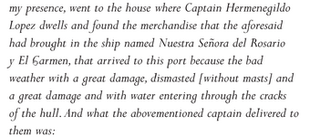
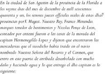
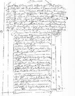
One of the ships made it to St. Augustine.

St. Aug. 1641 Fleet English Translation 1.png
St. Aug. 1641 Fleet English Translation 2.png

St. Aug. 1641 Fleet Spanish.png

St. Aug. 1641 Fleet distribution  document.png


This source (and it is a very good one), indicates that the Rosario arrived at St. Augustine dismasted on 29 Sept. 1641. The fleet is known to have left Havana on 20 Sept. 1641. The hurricane struck the fleet "a few days" after they left Havana, supposedly around 30 degrees North. Any way you slice it, it took them several days after the storm to reach St. Augustine. Travelling at a very leisurely 6 knots, they would have reached 30 degrees North in 3 1/2 days. On the 23rd or 24th of Sept. Yet they did not reach St. Augustine until 29 Sept. It took them at least 5 or 6 days after the storm to reach the town.
 

Last edited:

Jolly Mon

Hero Member
Sep 3, 2012
868
631
Primary Interest:
All Treasure Hunting
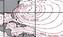
east coast currents.png

They would have had a choice of which way to go after the storm. At first I thought it likely the ships went aground somewhere near St. Augustine. The more I think about it, the less likely this seems. We know the Concepcion made it back to Hispaniola. We know the Rosario made it to St. Augustine. It just makes no sense for the Concepcion to attempt to make it back to Cuba after the storm if they were south of St. Augustine. They knew where St Augustine was. They almost had to have been north of it. But if the Rosario made it to St. Augustine, they could not have been THAT far away...the Rosario almost certainly could not have been many, many miles out into the Gulf Stream and yet be able to struggle back to St. Augustine. The surviving ships had to make a choice: Get east of the Bahamas and head back to Cuba via the normal route...or struggle back to St. Augustine along the shore, using the nearshore current as an aid...maybe using sweeps or being towed by the ships boats or under a jury rig...they were fairly close to St. Augustine, but not REAL close. South Georgia or extreme north Florida sounds about right.

The documents relating to the Rosario are available because of the remarkable fact that her skipper had almost the entire ship's cargo and munitions thrown overboard EXCEPT for a few crates of chocolate (LOL) and some sundries from the Manila trade. In other words EVERYTHING except the absolute most valuable cargo was thrown overboard to lighten the ship. Ditto for Concepcion. Did the 1715 fleet follow this example ? No. Why? Because the 1715 fleet had their hulls ripped apart almost immediately after grounding on the jagged reefs of east Florida. What is the difference? The 1641 fleet grounded on the SANDY BOTTOM north of Cumberland Island. The ships were not torn apart immediately. They had TIME to lighten.
 

Last edited:
OP
OP
H

hobbit

Sr. Member
Oct 1, 2010
304
110
Barring strong winds or very high surf, if you took a log to the 3 fathom curve off Jekyll Island and dropped it in the water...it would drift almost due south and wind up near the mouth of St. Augustine Inlet in 5 days.
 

Last edited:

stevemc

Bronze Member
Feb 12, 2005
2,121
277
Sarasota, FL
Detector(s) used
Whites Surfmaster PI Pro and Whites Surfmaster PI, Minelab Excal NY blue sword. 2 White's Dual field pi, Garrett sea hunter pi II (but don't use it for obvious reasons) 5' x 3 1/2' coil underwater Pi
Primary Interest:
Shipwrecks
I do know the waters off most of Georgia are shallow a ways out. Mostly sand. I have cruised from Florida up the East coast many times and that area is always skirted wide when going in the ocean, usually from Ponce inlet or St Augustine to Charleston, not much in Georgia, besides Savannah(which is a ways inland) , but I usually head much farther North before heading to land Plus the whole coastal area for miles is a giant swamp, no high land for miles of the coast, except near the large river mouths and some coastal dunes, making getting out to non bridged islands a fairly difficuly thing too. But as was stated, this area is not hit at all, and might be great for checking.
 

Last edited:

Vox veritas

Bronze Member
Aug 2, 2008
1,077
269
Primary Interest:
All Treasure Hunting
In my book "Galleons and Sunken Treasure" there is a chapter dedicated to this fleet (with a primary information source).
Cheers VV
 

herbert

Newbie
Sep 8, 2012
2
0
Primary Interest:
All Treasure Hunting
Meny years a go I read apage in a book. It sead that a dredge deepening a chanel in Miami.
When a cross from a marina police place when silver cobes came up in the dredge. I din't remember if they sead
they were spanish or not. after a short bit they were past the place. I think it wes in one of the old treasure found books.
good [email protected]
 

ivan salis

Gold Member
Feb 5, 2007
16,794
3,809
callahan,fl
🏆 Honorable Mentions:
1
Detector(s) used
delta 4000 / ace 250 - used BH and many others too
guess where 30 degrees is at in florida ? and guess whats offshore near that spot ? -- guess what those funny little "hard" stone rocks are that wash ashore after the storms in that area --humm odd that florida does not have any naturally occuring hard rocks of that type --wonder where they came from and what they could be from -?-oh here i s a real " wild guess" maybe they are some ballast stones from a spanish shipwreck or two perhaps you think ? --I mean after all the records say the wrecks occured there and ballast stones are there as well -- some folks make finding shipwrecks so much harder than it has to be-- wonder what a good through & "proper" magging hunt might turn up.

the screwed up part is you can only "beach hunt" dunes foot to waterline --since the state of florida WILL NOT issue any NEW WATER TYPE "SALVAGE" PERMITS *

so even if you find the 1641 fleet wrecks offshore you can not "legally" do a damn thing with them without the "proper" permits from the state of florida archies-- and good luck on that brother.--oh they will "issue" some "you may look but not remove or touch type permits" or "you may mag and do other science type things but you cannot remove or take anything off the bottom or shipwreck site type of permit" --you know the type of permits that just strings you along to do what amounts to "free research" for the state archies --but then when it comes time to "seal the deal" and its time for you to get the goods off the bottom to sell them to recoup your money and turn a profiet , -- it will be "no go" so sorry charlie . no "salvage" permit will be issued. bye bye sucker.

and if you say screw em and "poach" the wrecks and get caught --its go directly to jail for many years --have a nice day .

bottom line the state of florida dept of arch runs a rigged permitting "shell game" --that just strings along treasure hunters -- oh sure they will renew existing leases * but try getting a "new lease site" approved for a salvage op -- oh if you are a college or other egghead type non profiet group wanting to do non profiet type "research" fine no problem , heres yer permit but if you are a "for profeit outfit" wanting to harvest items to sell and make money -- nope
 

Last edited:

Salvor6

Silver Member
Feb 5, 2005
3,755
2,169
Port Richey, Florida
Detector(s) used
Aquapulse, J.W. Fisher Proton 3, Pulse Star II, Detector Pro Headhunter, AK-47
Primary Interest:
Shipwrecks
and if you say screw em and "poach" the wrecks and get caught --its go directly to jail for many years --have a nice day .

Wrong Ivan. One famous poacher (you know who I mean) worked the 1715 fleet for years. He finally got caught. Served no jail time, just probation.
 

Jolly Mon

Hero Member
Sep 3, 2012
868
631
Primary Interest:
All Treasure Hunting
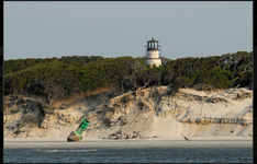
georgia beach bluff.png

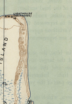
georgia island tip.png

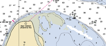
georgia island chart.png


If nothing else, it is a picturesque place to look for treasure...
 

Last edited:

Jolly Mon

Hero Member
Sep 3, 2012
868
631
Primary Interest:
All Treasure Hunting
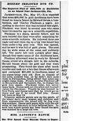
Interesting story from the area.

island treasure.png

Here is an interesting clipping. The newspaper is from 1897. There is a fairly famous pirate legend about this island as well...who knows?
 

Jolly Mon

Hero Member
Sep 3, 2012
868
631
Primary Interest:
All Treasure Hunting
DIGGING UP EVIDENCE OF 400-YEAR-OLD GLOBAL TRADE AND WEALTH

Largest 17th Century Bead Repository Found in Coastal Georgia
First Evidence of Spanish Beadmaking

French and Chinese blue glass, Dutch layered glass, Baltic amber: roughly 70,000 beads manufactured all over the world have been excavated at one of the Spanish empire's remotest outposts, the Santa Catalina de Guale Mission. The beads were found as part of an extensive, ongoing research project led by a team of scientists from the American Museum of Natural History on St. Catherines Island off the coast of Georgia. Comprising the largest repository ever from Spanish Florida, the beads enlighten archaeologists about past trade routes and provide clues to the social structure and wealth of the people.
"This is the northernmost outpost of the Spanish empire, but we see evidence of ancient trade routes from China via Manila's galleons to Mexico and Spain," says Lorann Pendleton, Director of the Archaeology Laboratory at the Museum. "We also have found perhaps the first evidence of Spanish beadmaking, along with beads from the main centers of Italy, France, and the Netherlands."

The mission of Santa Catalina de Guale was inhabited by Franciscan missionaries and local people for most of the 17th century. The mission was a major source of grain for Spanish Florida and a provincial capital until1680, when the mission was abandoned after a British attack. Since 1974, David Hurst Thomas, Curator of Anthropology at the Museum, and colleagues have been carefully unearthing this part of the island's history. The current research is based on the complete excavation of the church's cemetery and extensive survey and excavation in other parts of the mission. Years of analysis reveal roughly 130 different types of beads on the island, and numbers of specimens per type range from one to 20,000. Most of the more common beads are of Venetian and potentially French origin, with new research suggesting that one of the most common beads of the 17th century, the Ichtucknee blue, was manufactured in France. Some of the unique beads, though, may be Spanish, Chinese, Bohemian, Indian, or Baltic in origin.

While roughly 2,000 beads were found elsewhere at the mission (such as in the convent), most were found in the cemetery under the church. These were items intentionally deposited with individuals as grave goods, and the analysis of these items shows that there were subtle temporal and spatial changes in how the cemetery was used. Most burials found with large numbers of beads appear to date to the earlier part of the mission's history (the first half of the 17th century); items found with burials that date to the latter half of the 17th century are more likely to be religious medallions and rosaries. But because almost half the beads in the cemetery were buried with a few individuals who tended to be near the altar, it is often assumed that they were of high status in the community.

"A higher number of beads were found toward the altar, and some of the highest-status individuals (by number of beads) were children," says Pendleton. "This gives us lots of information about Guale society and means that status was ascribed with birth."

Elliot Blair, graduate student in the Department of Anthropology at the University of California at Berkeley, agrees but points out that "the picture that is emerging is turning out to be much more complicated than people had thought. It's hard to say whether the presence of the beads reflects native or church hierarchies, the presence of wealthy individuals, or something else entirely. Still, this is the largest assemblage of beads ever found in a Spanish mission in La Florida, and the study of these materials has yielded considerable information about how Guale society, burial practices, and Spanish missionization changed during the 17th century."

The number of beads found on St. Catherines Island suggests that Santa Catalina de Guale was a relatively wealthy outpost. The island is fertile and was the capital of a mission province, both potential explanations for the high number of beads found when compared to other missions.
first santa catalina beads pic.png
From left to right: Common cobalt blue seed bead, most likely from Venice (20,906 found); unique blue green melon bead from China; Spanish gilded oval glass bead (15 found); ichtucknee plain turquoise blue bead with white patinas now thought to be manufactured in France (one of 5,265); On top greenish blue faceted bead or charlotte from the Margariteri guild of Venice (138 found); bottom Venetian turquoise/green-blue seed bead or rocaille (5777 found); five layer chevron compound bead from the Netherlands (3 fragments); unique bead of opaque blue over transparent blue with stripes, probably from the Paternostri guild of Venice; Green Heart bugle bead with a thin clear veneer over red-orange glass over green glass from the Margariteri guild of Venice (one of 5); and a speo Green Hearts from the Paternostri Venetian guild (one of 12).
treasure, st catherine's beads 2.png
From left to right: On top French manganese black opaque bead, some created with the a speo process; bottom Spanish spherical dot-incised gilded glass bead (6 found); cut crystal, potentially manufactured in Spain because of inferior quality to known beads from France or Venice (6 found, as well as other nonglass beads of carnelian, jet and amber); On top unique yellow melon shaped bead, possibly from China; bottom Chinese wound translucent-transparent green (4 found); blown black bead with greenish-yellow dots (13 found with one burial that are potentially French); wound green faceted teardrop (unique, of unknown origin, and not found with a burial); and Spanish cross of manganese black glass decorated with white waves and light blue dots (one of 5).


American history books have long disparaged the Spanish presence in America, discounting “poor little St. Augustine” as one of the most impoverished outposts in the Spanish global community. The colonists self-characterized La Florida as a place of neglect and ruin.

For 15 years, I directed Museum excavation at this extraordinarily well-preserved 16th- and 17th-century Franciscan mission, and I can safely say that those history books are dead wrong.

The archaeology produced surprises from the very start. The church and surrounding mission buildings were well constructed and carefully laid out on a town grid. Knowing that Franciscan customs dictated that the mission cemetery be placed inside the church, we encountered the remains of more than 400 people interred there. We were shocked by the quantity and quality of the grave goods we recovered. Having excavated several burial mounds on the island—often loaded with mortuary offerings—we knew that indigenous St. Catherines Islanders had long felt that “you can take it with you” to the afterlife. The Guale people clearly continued to place grave goods with the Christian burials. We puzzled over why the Franciscan friars would permit such “heathen” customs to be practiced at Mission Santa Catalina.

As the archaeological evidence accumulated, we began to question the conventional historical wisdom.We were also startled by the remarkable artifacts we found—gold and silver medallions, silver sacred heart rings, bells, mirrors, several complete ceramic vessels, and more than 65,000 glass trade beads. How did the mission Indians at Santa Catalina obtain some of the world’s most valuable beads, imported from Europe, China, and India? How did this tiny settlement on the Georgia coast—the so-called outpost of an impoverished outpost—become enmeshed in a global exchange network?
 

Attachments

  • treasure, ga, st catherine's island, american museum of natural history, decades of discovery at.png
    treasure, ga, st catherine's island, american museum of natural history, decades of discovery at.png
    31.1 KB · Views: 219

Top Member Reactions

Users who are viewing this thread

Latest Discussions

Top