You are using an out of date browser. It may not display this or other websites correctly.
You should upgrade or use an alternative browser.
You should upgrade or use an alternative browser.
1641 Plate Fleet information
- Thread starter hobbit
- Start date
cuzcosquirrel
Hero Member
- Aug 20, 2008
- 562
- 133
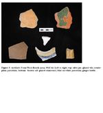
That looks like material from a midden in an indian village close to a wreck site. One of the pieces appears to have been knapped, or flaked (the green piece.)
The presence of 70,000+ trade beads, almost all funerary offerings, in an archaeological context is astounding in a small village. It is possible these beads were simply traded for food and skins, of course...but if 70,000+ beads were found in the digs...how many were actually traded to the indians ...and for what
 Just food and skins?? Add to this the amount of gold and silver present in the Indian burials and it is a real head scratcher. The Spanish would have traded almost anything in 17th century Florida for food, of course. But they would NOT have traded silver and gold. Yet silver and gold ornaments are found in relative abundance as funerary offerings at St. Catherine's Island. Where did it come from?
 ...and for what
 Just food and skins?? Add to this the amount of gold and silver present in the Indian burials and it is a real head scratcher. The Spanish would have traded almost anything in 17th century Florida for food, of course. But they would NOT have traded silver and gold. Yet silver and gold ornaments are found in relative abundance as funerary offerings at St. Catherine's Island. Where did it come from?
That looks like material from a midden in an indian village close to a wreck site. One of the pieces appears to have been knapped, or flaked (the green piece.)
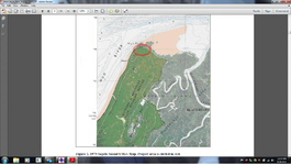
Possibly. Very possibly. I am almost certain of one thing though: the Guale Indians would NOT have had a permanent village site at that location. No way. Which makes the presence of the material even more intriguing. The tip of a barrier island. The south side of an inlet...St. Catherine's Island is just north across Sapelo Sound.
Last edited:
- Thread starter
- #46
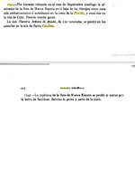
From Armada Espanola by Duro:
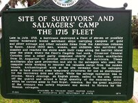
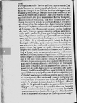
"1641-por huracan reinante en el mes septiembre naufrago la almiranta de la flota de nueva espana en el bajo de los abrojos; cinco naos mas embarrancaron o zozobraron en la costa de la florida, y otras dos en la isla de cuba, perecio mucha gente.
La nao nuestra senora de ayuda, de 230 toncladas, se perdio en los arrecifes de la isla santa catalina."
Translation: "1641-Hurricane month prevailing in September wreck the flagship of the fleet of New Spain under the thorns more embarrancaron or five ships capsized off the coast of Florida, and two on the island of Cuba, many people perished .
The galleon Our Lady of Help, 230 toncladas, was lost on the reefs of Santa Catalina Island."
To my knowledge there are two islands called "de la Isla Santa Catalina" in the area in question:
One is on the south side of Hispaniola, well off the coast...
The other? In Georgia:
"Isla de la Santa Catalina"... english translation: St. Catherine's Island.
You decide.
Most writers have assumed the Isla de la Santa Catalina in question is the one in Los Angeles County and the nao a Manila galleon...
I am not so sure.
"1641-por huracan reinante en el mes septiembre naufrago la almiranta de la flota de nueva espana en el bajo de los abrojos; cinco naos mas embarrancaron o zozobraron en la costa de la florida, y otras dos en la isla de cuba, perecio mucha gente.
La nao nuestra senora de ayuda, de 230 toncladas, se perdio en los arrecifes de la isla santa catalina."
Translation: "1641-Hurricane month prevailing in September wreck the flagship of the fleet of New Spain under the thorns more embarrancaron or five ships capsized off the coast of Florida, and two on the island of Cuba, many people perished .
The galleon Our Lady of Help, 230 toncladas, was lost on the reefs of Santa Catalina Island."
To my knowledge there are two islands called "de la Isla Santa Catalina" in the area in question:
One is on the south side of Hispaniola, well off the coast...
The other? In Georgia:
"Isla de la Santa Catalina"... english translation: St. Catherine's Island.
You decide.

Most writers have assumed the Isla de la Santa Catalina in question is the one in Los Angeles County and the nao a Manila galleon...
I am not so sure.
Last edited:
Jason in Enid
Gold Member
- Oct 10, 2009
- 9,593
- 9,229
- Primary Interest:
- All Treasure Hunting
Hobbitt, I have read this thread with much enthusiasm. I commend you on your efforts, research, and analytical thinking. A few things have occurred to me. If the ships were carrying durable, salvageable goods and were wrecked upon shoals, then they would have most certainly been salvaged and there would be records of this. Second, much of your supposition is based on the storm track. Since we know the rough dates of the hurricane, won't you be able to find record of the storm passing other islands? Combining this data with the typical right-curving of storm tracks should give you a very solid basis for the path of it. Knowing that with the route taken by the fleets would show you when, where, and how they might have been pushed by the storm.
Good luck! I wish I could join you in your search. <I wouldn't be adverse to dropping a mag or detector over the side as I leisurely enjoyed a day of sailing >
>
Good luck! I wish I could join you in your search. <I wouldn't be adverse to dropping a mag or detector over the side as I leisurely enjoyed a day of sailing
 >
>jffbrk
Jr. Member
- Aug 26, 2012
- 83
- 22
- Detector(s) used
- Garrett AT Pro
- Primary Interest:
- Beach & Shallow Water Hunting
aquanut
Bronze Member
Have you seen the museum of found gold, silver, and artifacts at Sebastian Inlet? Was just there last week and it is fascinating. Only $2 to go through the State Treasure Museum.... View attachment 694217
When you were there, did you notice if they had posted my flyer about the Treasure Hunter's Cookout/ Benefit for this Saturday!
Aquanut
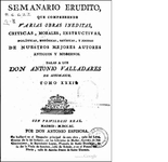
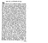
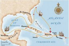
9 days from Havana and clear of the Bahama Channel...could they have made it to Bermuda?
Of three ships there is no doubt:
Concepcion wound up in the D.R...
El Carmen, with her precious few crates of chocolate, wound up in St. Augustine...
Juan de Campos in the Capitana made it back to Spain...
Last edited:
SADS 669
Bronze Member
- Jan 20, 2013
- 2,454
- 3,734
- Detector(s) used
- Tesoro Sand Shark....Aqua pulse 1B....Equinox ll
- Primary Interest:
- Shipwrecks
hobbit said:Very interesting. If this is correct, two sailed back to Cuba and two to Hispaniola. I can only surmise that they were well offshore after the storm and made the same decision to sail south as did the Concepcion. Thanks for the references from the Archives. I need to find a paleographer who works cheap.
Did the entire fleet sail south after the storm? Or was the fleet broken-up, with some being driven north and/or west and aground in La Florida first, while those that survived were driven northeast/east by the counterclockwise flow after the passage of the storm? Or were they driven south and aground in the Bahamas by the storm to begin with? That doesn't jibe well with the accounts, though.
Diver_Down said:Something has been eating at me regarding The Cliff. On Little Talbot Island (south end), is an area called The Bluffs. The south end also comprises the norther border of Fort George Inlet. Vessels could have been looking to take shelter from the storm ...
Don't forget when the the world is falling around you and death is a real possibility a really big sand dune may look like a cliff so you are certainly on the right track with a bluff
Diver_Down
Silver Member
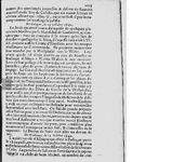
From La Gazette, Oct 11, 1642
...
Anyone have a rough translation? My French is lacking (none at all).
- Thread starter
- #56
Anyone have a rough translation? My French is lacking (none at all).
It doesn't really say much specific---just that the finances of the Spanish have been upset by the loss of two years of merchandise by the New Spain fleet---it reports that all of the galleons were lost in a terrific storm, which, of course is incorrect. It is a very early source document, though. And it supports the idea of much of value being lost by the Spaniards in the 1641 disaster, even though the Almiranta and Capitana were accounted for.
Last edited:
A clue perhaps
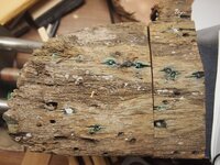
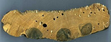
This timber was sent to my institution in July 1966. A note attached says approximately "Sent by Charles Hoffman from Boca Raton shipwreck associated with 1640 coin" with the date. One end has been violently broken, some barnacles are present as well as shipworm damage. The timber is oak from Germany cut after 1586 and appears to be a piece hull planking with a hole drilled for a treenail, copper alloy nails that held lead sheathing at one time, and a place where a square copper alloy spike was driven through at one end (the broken end). Likely the plank came from a tree felled between 1600 and 1650 (missing sapwood and some heartwood rings). I have little other information about it at this point and no idea where exactly it was found or anything about the purported coin. The was a big hurricane in 1964 that swept up the coast and following this storm some cannon were found north of Boca Raton I believe.
The 1641 return fleet was made up of 30 vessels - 21 had made the trip from Spain and were returning and 9 had been newly built in Cuba and were an armed escort. I suspect the escort was expected to sail with the fleet until they departed the coast for open ocean and then return to patrolling the Caribbean. Peter Earle's book suggests that all 9 escort ships survived the hurricane and made their way back to Cuba, Puerto Rico, and Hispaniola. One of the "most heavily laden merchant ships" from the fleet also turned up in Hispaniola.
The N.S. Concepcion was reportedly built in Havana from native timber (~600 tons) and refitted in Cadiz before the voyage to 680 tons.
I don't currently have a list of all the vessels in the fleet and their place of construction but am working on that. One problem is the Spanish ship names seemingly pull from a small pool of saints so names like "Concepcion", "Rosario", "Atocha", are recycled multiple times and one needs the full long form name (and a date) to be sure which particular ship is being referred to. See for example: A Plague of Ships: Spanish Ships and Shipbuilding in the Atlantic Colonies in the 16th and 17th centuries
Earle's book goes on for quite a bit on the poor navigation skills of the Concepcion's pilots. Before being overtaken by the hurricane the fleet was tacking against the wind trying to sail north along the coast of Florida. The "30 deg N lat." info is from one or more of the accounts of the survivors - who knows how accurate it is. How rough were the seas when the last reading was taken for instance?
old man
Bronze Member
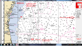
TRG, I haven't been following this thread. Are you looking for a wreck at 30 deg. N. If so, I know where there is one from a fisherman's chart I have. I plan on diving it this summer.
If that's not what you're asking? I apologize.
If that's not what you're asking? I apologize.
TRG, I haven't been following this thread. Are you looking for a wreck at 30 deg. N. If so, I know where there is one from a fisherman's chart I have. I plan on diving it this summer.
If that's not what you're asking? I apologize.
Greetings old man, I am feeling that way myself of late although I'm not sure what qualifies as "old" these days. At any rate I am long past contemplating a new career treasure hunting off the Florida coast, but thanks for your offer. As a teenager I did a two week stint on a shrimper out of Key West back in 1972 and I doubt that I will be down in the neighborhood again in this lifetime.
30 deg. N is in reference to the last reported position of the Nuestra Señora de la pura y limpa Concepción, Almiranta of the 1641 plate fleet that was overtaken by a hurricane off the Florida coast. Somewhere near Saint Augustine it is thought. A number of the vessels sank, some were driven ashore, and others made their way, heavily damaged, back to various ports. Only the Capitana made it back to Spain. The artifact pictured is reportedly from a shipwreck in the Boca Raton area and was associated with a "1640" coin(s) suggesting that it might be from one of these ships, however Boca Raton is considerably south of the last reported position, the storm came up from the south and the current is flowing north - so either the last reported position is incorrect or the artifact is from some other ship. I have too little information to resolve this issue and none of the lost ships has been found (of course with the famous exception of the Concepción).
Top Member Reactions
-
 2345
2345 -
 1131
1131 -
 1055
1055 -
 891
891 -
 834
834 -
 781
781 -
 751
751 -
 748
748 -
 607
607 -
 502
502 -
 488
488 -
 475
475 -
 461
461 -
 420
420 -
 397
397 -
 393
393 -
O
393
-
 383
383 -
 381
381 -
 381
381
Users who are viewing this thread
Total: 2 (members: 0, guests: 2)
