signumops
Hero Member
- Feb 28, 2007
- 756
- 226
- Detector(s) used
- Garrett, Minelab, Aqua-Pulse
- Primary Interest:
- All Treasure Hunting
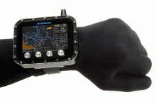
I'd have to say this is probably the best new tool available to us in the past several years...
Navimate - GPS for Divers
Navimate - GPS for Divers