THE JUPITER 17TH CENTURY HISTORIC SHIPWRECK SITE

WHO WANTS TO KNOW MORE ABOUT THE JUPITER SHIPWRECK SITE AND HELP TO FIND OUT, 'JUST WHERE IS THE RES

  • WWW.JUPITERCOINS.COM

    Votes: 0 0.0%
  • ASK ANY QUESTION

    Votes: 0 0.0%
  • DO YOU WANT TO TAKE PART IN OUR TREASURE HUNT?

    Votes: 0 0.0%

  • Total voters
    0

capt dom

Hero Member
Nov 9, 2006
995
282
Jupiter, Florida USA
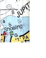
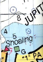
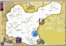
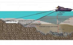
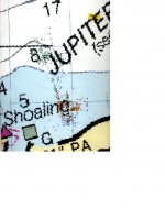
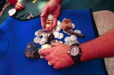
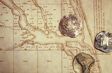
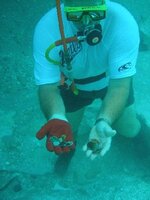
Since 1987 our 17 century Jupiter Shipwreck site has yielded significant treasure! Even today coins are surfacing from the deep! {Check out the recent Seahunter & Rio Bravo posts and threads.} { They were just south and on the western edge of the first ridge in the cross sectional drawing below. Where they dug is marked "jetty rock". } The Rio Bravo sure can dig a big hole! But, we are going to have to dig even deeper still!
But, the main cultural deposit has alluded all who have searched for it. We at Jupiter Coins now beleive it is because everyone - including us has dug right over the main pile! Like in the movie "The Deep", there is more than one layer of this shipwreck site and we need to develop better - more efficent methodologies to dig deep enough - so as to get to the mother lode. We at Jupiter Coins are actively seeking advice and input from those of you out there. Join with us in our adventure in discovery!

P.S. And remember, you have to really check out all the cracks....

Capt Dom
 

Attachments

  • Turned Boat3.JPG
    Turned Boat3.JPG
    106 KB · Views: 1,923
  • Scatter Pattern.jpg
    Scatter Pattern.jpg
    40.7 KB · Views: 742
  • pict0005.jpg
    pict0005.jpg
    38.7 KB · Views: 860
  • pict0013.jpg
    pict0013.jpg
    70.9 KB · Views: 804
  • pict0003.jpg
    pict0003.jpg
    57.7 KB · Views: 836
  • Dom with Coins.Jpg
    Dom with Coins.Jpg
    33.1 KB · Views: 883
  • pict0046.jpg
    pict0046.jpg
    36.1 KB · Views: 831
  • pict0045.jpg
    pict0045.jpg
    23.1 KB · Views: 832
  • Set up Venturi.Jpg
    Set up Venturi.Jpg
    28.2 KB · Views: 861
OP
OP
capt dom

capt dom

Hero Member
Nov 9, 2006
995
282
Jupiter, Florida USA
Dear Cornelious,

The actual artifact scatter pattern and my version of the story and has them being wrecked in a north east gale. Your story sounds great but its about another shipwreck event. We have ballast scatter but not a significant amount. Our vessel may have had up to 120 passangers and crew. (Eugene Lyons has 33 survivors being brought to Havana.

Your not the first to propose this scenario. In fact Seahunter got mag hits out in that direction but... look where he is working.. I can show you an actual map of the known scatter pattern but read my version first

Capt Dom, not to be confused with Capt Doom!


CHAPTER 2.

{Wrecking of the San Miguel}
Fifty Souls had made it top side. Ten of which, were immediately washed overboard, as the upper deck was taken by the next - ever growing ground swell - surfing the deck, with remaining forty odd souls toward their awaiting fate. The rest of the passengers and crew compliment were to never surface again - staying with the sheared pitch-bolted hull - buried under the weight of the San Miguel's unscheduled and unrecorded cargo of bullion - crushing the air from their lungs, beneath the sea just in sight of land - they would never see..

Most of the passengers and crew still remaining on the main deck were scrambling for the rigging and the stern quarter. It was an odd sight to Sea Eagle, watching from the top of the largest mound at the estuary - the upper deck alone - of this once great ship - surfing - into his estuary on a great rouge wave
{ just one hour yet 150 lives earlier}
Fate is the whim of the gods and they have an interesting sense of humor when it comes to man. Time was bending itself around an event - whose destiny was ordained. The winds had risen to past gale force and the San Miguel, after having jibed was now under bare polls - with all drogues out - still exceeding its hull speed.. Doom was inevitable. The question was could Orlataca keep her afloat long enough for the winds slamming the heavily burdened vessel - from the north-northeast to drive the San Miguel up and on the beach. Orlataca bellowed a laugh and said to himself, "I'm making a pack with the devil, "To keep my ship afloat - just long enough so as to wreck her on the beach"! "Get us some rum from my quarters", Orlataca ordered his number two and pilot Diego Garcia. "Bring our braces and two Archebuses as well".

"Aye Captain sir", was the number two Diego Garcia'a reply - already on his way below. Once there he encountered Juan Ramariz de Miranda. "Sir you had better prepare yourself for the worst - We are either going down to the deep or on the beach - there is no middle ground"! Before de Miranda could respond - number two, Garcia was gone with weapons in his hands and brace pistols slung over each shoulder. With his life on the line, Miranda was no longer ill. Now he was scared. The king's "quinto" didn't matter - the special package - for Philip the 4th - didn't matter - the only thing that mattered was that he get out of this cabin and onto the deck of the San Miguel. This was a death ship and he knew it. They - no sooner left port, when the plague began to inflict its toll on the ship's passengers and its crew. They first felt a great fever - then those so afflicted's bile went from yellow to black, next came the boils - then death.

Two passengers cast themselves over the side when they realized that the ship had been so infected. The ship was refused port in Havana and now flew the yellow quarantine flag. When the San Miguel reached the top of a particularly large breaking swell, the look out repeatedly shouted - land ho - off the starboard port quarter. But surfing down the next trough - the sky disappeared - as the bow dug its prow into the blue abyss. Half of the crew were washed overboard - before the vessel surfaced - immediately regaining hull speed. It was impossible to take soundings in these conditions but based upon the color change of the water Orlataca reasoned that they were in seventy to ninety feet of water and the shore would be fast upon them. The seas were so steep - he now feared an even greater catastrophe. If his bow was to be caught in another trough as the one she just - barely survived, she may strike the bottom and splinter - never to resurface.
 

mad4wrecks

Bronze Member
Dec 20, 2004
2,263
107
Detector(s) used
Aquapulse, DetectorPro Headhunter, Fisher F75
Primary Interest:
Shipwrecks
That was obviously Capt. Dom's (quite colorful) interpretation of the events, based on what I hope is the sound archival evidence found by Eugene Lyons. So when does the book come out Capt Dom? I want one!

Since the San Miguel was lost either late 1659 or early 1660, it was probably a nor'easter and not a hurricane that wrecked the ship. Therefore it may have encountered gale force winds, but not hurricane strength winds, so I doubt the valley of the waves were 15 feet deep as Cornelius suggested. Also, an aviso is not a large ship, the draft less than 12', so it would have come in pretty close to the beach before striking bottom.

Pushed back towards the southwest, the crew may have started tossing heavier objects overboard in an effort to lighten the ship, (but Dom made no reference to this) as they tried to make it inside the inlet or cut that existed at that time. There may actually be artifacts to the northeast of the site in this case

I doubt if this ship is as scattered as say, one of the 1715 fleet ships hit by a hurricane, with a resulting 2-3 mile scatter pattern.

What type of anomaly pattern has a mag survey revealed at the Jupiter site? My guess is a fairly, tight, compacted debris field????

Just my 2 cents

Tom
 

wreckdiver1715

Bronze Member
May 20, 2004
1,721
151
Satellite Beach
Detector(s) used
Minelab Excal 1000
Primary Interest:
All Treasure Hunting
Capt Dom. welcome to the Shipwreck Forum, we always like to see our fellow local treasure hunters participate with us at TreasureNet.
Oh! and I love the name of your boat. 8)

Welcome aboard

Tom
 

ScubaFinder

Bronze Member
Jul 11, 2006
2,220
528
Tampa, FL
Detector(s) used
AquaPulse AQ1B - AquaPulse DX-200 Magnetometer
Primary Interest:
Shipwrecks
Hi Dom, It's Jason (the guy who reeled out the water hose to you from the Rio Bravo :) ) How did you established the depth of the sand at nearly 30 feet, by probing or a sub-bottom profiler, or is it an educated guess? Sounds like you've got a good theory, I never knew you guys were blowing 12 feet deep and still searching sand!

I like the deep water theory for a few of the wrecks North of Jupiter, but not for this one. Every account I have read has them tacking into a north-easterly wind, and all accounts have them doing it in the winter months after hurricane season. If they were 3 miles off shore, I doubt that 33 souls would have made it to land through seas that rough.

Jason
 

OP
OP
capt dom

capt dom

Hero Member
Nov 9, 2006
995
282
Jupiter, Florida USA
Here is a copy of the known scatter pattern.

Also here is a copy of where the solution holes are.
The one inside is ours to work and the one we have been gearing up to excavate for over three years now.
you guys were just south about 100 feet and just west by about 150 feet from its edge. If you look at our profile ariel you can see our digging pattern all summer is directly pointed at it.

This winter I am most probably going to put a set of 40 inch tubes on the "Enterprise".
There is no question - if we wanted to dig where you were digging, it would have taken us all summer with our deflectors to do what you did in two days....

But, in 12 feet of water no matter how many pilot hole you dig - I can't imagine how any blower boat can possiibly dig to an overall depth of 40 feet +.... and that is what we are going to have to do to get to the bottom of these solution holes. Now, if we can coordinate it around a similar weather pattern I will charter your vessel and also cover reasonable expenses and agree to the same share of net salvage material as Scott did with you but, we are going to have to place a suction dredge as well aboard your boat or mine working in tandom.

When we get into the original scatter pattern I am stating is still untouched out there... at about 26 to 32 feet of over all excavated depth that is when the suction dredge can keep control of the sand and place it down stream safely - while the divers are working the hole and the sand will bypass the inlet and eventually nourish the southery beaches.

Now, what do you think of this?
 

Attachments

  • Blue circles.jpg
    Blue circles.jpg
    39 KB · Views: 721

Salvor6

Silver Member
Feb 5, 2005
3,755
2,169
Port Richey, Florida
Detector(s) used
Aquapulse, J.W. Fisher Proton 3, Pulse Star II, Detector Pro Headhunter, AK-47
Primary Interest:
Shipwrecks
Hey Dom, I heard a couple stories about the San Miguel. One is that when they dredged the Jupiter inlet the dredge hit ballast stones and coins. The dredge spit out coins and stones on the beach. This was 1,000 feet further east of where you and Scott were working. Another version says they were doing beach renourishment. My research also indicates there was a second ship in the convoy that sank in this area; the San Antonio. I talked to Eugene Lyons and he said he doesn't have any documents on either vessel. He directed me elswhere to find more info. You need to go further offshore to find the mother lode.
 

OP
OP
capt dom

capt dom

Hero Member
Nov 9, 2006
995
282
Jupiter, Florida USA
To salvor 6,

Thanks for reading my posting.

An aviso vessel named San Antoinio left Cadis in late 1658 based upon some research Peter Leo and I got from Victoria Staples Johnson in Seville back in the early 90's. Attached is a photo of us. We therefore fist thought that was the vessel we located But later research from her had the San Antoinio making it back to Cadiz in 1659! Now thats not to say it did do a turn around and sink later over here.

I am adding a photo of Pete and I in Seville with Victoria note the brown hair! This was taked 18 years ago!
 

Attachments

  • pict0019.jpg
    pict0019.jpg
    53.1 KB · Views: 714
OP
OP
capt dom

capt dom

Hero Member
Nov 9, 2006
995
282
Jupiter, Florida USA
The dredgers were suppose to avoid our direct search area but its a big ocean! And, shipwrecks scatter far and wide... on a weather coast. But Cornealious... look at the scatter pattern of material we have recovered yelow and red marks are multiple coin and artifact finds, green are ballast stones. Now I'm going to give you a lesson. Ships after they wreck, at a point of impact scatter out, not in. Attached is another chart illustrating just where the solution holes are located. Now if you overlay them.... two of the solution holes lay in the direct path of the scatter pattern! Lesson # 2. The sand out there today has only been there since 1920 when they moved jupiter Inlet 1000 feet Island move off shore creating a halo new sand bar.

Attached are some more clues.

Blowers in 10 to 15 feet of water can only dig a hole about another 10 feet deep. After that the ridge of the hole gets so high - the sand just can't lift out of the hole! If you try harder to go deeper... all you do is drive coins and artifacts deeper into the sand column.

Question #3 To all of you out there is this... How do coins and artifacts from a 1660 shipwreck end up in a sand bar that wasn't even ther until 1921 and later... Think about that one for a while....
And, Cornelious the shipwreck may lay in the blue circled south east solution hole but for now I am betting on the one closest in as it is direrctly allong the scatter path that is consistantly yielding coins and other artifacts.

One final observation.... Stop referring to 3 or 4 miles out...! If you new the gulf stream in this area you would know the water is 1,500 to 3,500 feet deep! The hydrology of the coast line changes dramatically along the Florida coast right here in Jupiter.

Any diver who wants to take the time can just where the inlet was offshore - when the sea level was lower during the last wo ice ages just by observing the reef structure off shore at 65 to 95 feet and that is less than 1 mile.

A ship can start to sink 2 or 3 or whatever miles out but where it finally goes down is what really matters. If a ship is going to sink in 2,000 to 3,000 feet of water there in no way anything but floatsom & jetsom is going to make it to the beach... Now - have I put the 2 to 3 miles out bit to rest?
 

Attachments

  • PI5Send6.Jpg
    PI5Send6.Jpg
    41.7 KB · Views: 691

Chagy

Bronze Member
Dec 20, 2005
2,226
121
Florida
Detector(s) used
JW Fishers Pulse 8X
Primary Interest:
Shipwrecks
Ohh boy, I am starting to hear the theme song of the movie Rocky in the back of my head ;D :D :D :D :D

Cheers,

Chagy.......
 

OP
OP
capt dom

capt dom

Hero Member
Nov 9, 2006
995
282
Jupiter, Florida USA
No problem (EDIT BY WRECKDIVER1715)

You are entitled to your opinion...
Do you Know how to sail? These boats didn't sail a damn to windward ... Even a Dutch Flute which we think the San Miguel may have been. The VOC markings were chipped off the iron cannons... {something the Spanish often did when they conscripted a ship} but I am sure you new that...

When the San Miguel came in ahe came in fast and hit hard.. She did hit the southern tip of a barrier island... Jupiter Island. see attachment.

When she hit her upper deck split at the cannon ports and pitchbolted... of this we are certain

Pardon me for attempting to teach you anything.... When I grow up and can afford it I will go out and purchase a submersible that is capable of diving in 1,500 to 2,000 feet of water! Along this area the gulf steam trench is probably littered with coins fooating about in the 1 to 4 knot prevailing currents of the Gulf Stream
 

Attachments

  • pict0003.jpg
    pict0003.jpg
    57.7 KB · Views: 811
  • pict0003.jpg
    pict0003.jpg
    57.7 KB · Views: 666

riobravo

Sr. Member
Apr 2, 2006
250
2
south texas to the east coast
hi again capt dom,
just for the record, i have the experience to dig well past your predictions, and this can be accomplished with differant methods.
heck with enough time i could dig till you see some rice roots ;D ;D
 

Salvor6

Silver Member
Feb 5, 2005
3,755
2,169
Port Richey, Florida
Detector(s) used
Aquapulse, J.W. Fisher Proton 3, Pulse Star II, Detector Pro Headhunter, AK-47
Primary Interest:
Shipwrecks
My buddy had a contraption he called an 'elephant trunk' that was attached to the end of his blower (single). He was blowing through 10' of sand in 30' deep water with his Detroit 6-71 diesel. It was nothing but a canvas tube attached to the end of the blower. You can grab the end of the tube and swivel it around while blowing to direct the excavation. If you have the right tools anything is possible.
 

Smithbrown

Bronze Member
May 22, 2006
1,002
831
Capt Dom

I am very intrigued by your mention of iron guns with the VOC badge chiselled off. Most of the examples I have seen of VOC guns have the initials engraved in, except for some late 18th century examples which have a VOC-H badge cast on. Have your examples had a badge cast on them, or has engraving been removed? And do they have trunnion marks? Most of the examples i have are later, 18th century ones so that I am always keen to hear about earlier examples.

Smithbrown
 

Peg Leg

Bronze Member
May 29, 2006
1,520
5
Does anyone have photos of SPANISH bronze swivel cannons OR can give information where I can find such photos?
Thanks
Peg Leg
 

OP
OP
capt dom

capt dom

Hero Member
Nov 9, 2006
995
282
Jupiter, Florida USA
The cannon ports were the weakest point of construction on a mid-17th century caravelle.
Pictured here is a computer generated graphic my wife did of the San Miguel striking the then exposed hard bottom reef structure causung the awash sand bar extending from the south end of Jupiter Island.
 

Attachments

  • Wreck 2.JPG
    Wreck 2.JPG
    121.9 KB · Views: 574
OP
OP
capt dom

capt dom

Hero Member
Nov 9, 2006
995
282
Jupiter, Florida USA
Whoops!

file was too big...
The cannon ports were the weakest point of construction on a mid-17th century caravelle.
Pictured here is a computer generated graphic my wife did of the San Miguel striking the then exposed hard bottom reef structure causung the awash sand bar extending from the south end of Jupiter Island.

Here a second attempt..

Capt Dom
 

Attachments

  • Small shipwreck.jpg
    Small shipwreck.jpg
    61.9 KB · Views: 1,027
OP
OP
capt dom

capt dom

Hero Member
Nov 9, 2006
995
282
Jupiter, Florida USA
Ah, now that that one went through I'll try and send a copy of the lazer theodilite posisioning for earlier finds of the pitchbolted upper deck structure - with anchors still in place.
 

Attachments

  • compressed old scattered pattern.JPG
    compressed old scattered pattern.JPG
    27.3 KB · Views: 465

Top Member Reactions

Users who are viewing this thread

Latest Discussions

Top