Winter Beach Salvage Camp and Cannon Wreck Book per Doug Armstrong

signumops

Hero Member
Feb 28, 2007
756
226
U.S.
Detector(s) used
Garrett, Minelab, Aqua-Pulse
Primary Interest:
All Treasure Hunting
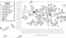
I was going to put Doug Armstrong's reprint of the Winter Beach Salvage Campsite excavations to the press shortly. Meanwhile, he let me look over his 1990 season report for Steve Shouppe's Tequesta work at the Cannon Wreck site. I rectified his dig chart from UTM to GPS style coordinates. I attached a screen shot of part of it. Be aware that none of these holes jive with the Fisher charts circa 2004.

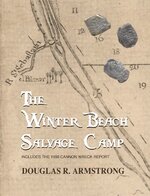
Fortunately, Doug has agreed to let me add this report into the volume on the Winter Beach excavation, even though they are not related directly. His report on the 1990 Shouppe season is quite interesting, and only 4 copies were prepared. It was a typewritten report with xerox copies of the artifact drawings and daily logs, along with the Master Site tickler and a letter from a cannon authority in England sent to Roger Smith. He also included a Topo in UTM showing where the Iron Pile wreck lay in relation to the Cannon Wreck. His dig chart also has some indications of a 1900's debris pile in the vicinity of the Cannon Wreck.

Now, I have all the daily work sheets, which are based upon the beach markers and I wonder if I should publish them along with the other material? If I print at 8.5 inch by 11 inch, you could probably read them well enough. Any advice on this issue?
 

Attachments

  • GPSshot1.jpg
    GPSshot1.jpg
    244 KB · Views: 462

mad4wrecks

Bronze Member
Dec 20, 2004
2,263
107
Detector(s) used
Aquapulse, DetectorPro Headhunter, Fisher F75
Primary Interest:
Shipwrecks
Terry, I think you should publish the daily work sheets. They should be legible at 8.5 x 11. I am looking forward to this publication.


Tom
 

theseeker

Sr. Member
Mar 4, 2009
345
139
Detector(s) used
White's Surf PI Pro Dual Field/Minelab Sovereign Elite/Goldbug II/Goldbug Pro
I agree with Tom, publish the daily work sheets. I think it would boost sales as well.

Pete
 

OP
OP
signumops

signumops

Hero Member
Feb 28, 2007
756
226
U.S.
Detector(s) used
Garrett, Minelab, Aqua-Pulse
Primary Interest:
All Treasure Hunting
Everybody needs to remember that all of these fixes were plotted using a sextant, and done on paper. There's nothing about this information that can be as exact as the fix data collected with GPS. Doug is not sure that the Fishers even saw this information to start out with. Doug also indicated that there definitely had been other people digging there before Shouppe, from what he could tell.
 

OP
OP
signumops

signumops

Hero Member
Feb 28, 2007
756
226
U.S.
Detector(s) used
Garrett, Minelab, Aqua-Pulse
Primary Interest:
All Treasure Hunting
The book will be available at Amazon in about five days. $11.95 plus shipping. I will have some at the Treasure Hunter's Cookout in April.

166 pages, over 40 photos, 7 maps, and 26 illustrations. The original Winter Beach Salvage Camp report is now indexed. The blurb from the back cover:

One of the worst maritime disasters in Florida’s history occurred in 1715 when the Spanish Plate Fleet, bound for Spain, was trapped in a hurricane that dashed almost all of the ships against the beaches along the central east coast of the state. Spain salvaged what they could for several years before closing down operations. Today, one of the central salvage camp locations from the Spanish effort can be found where Florida has established the McLarty Shipwreck Museum on the beach just south of Sebastian Inlet.


The Spaniards constructed several camps along the fifty miles of coast where the ships sank, the primary one being at the McLarty Museum site on the northern extent of the wreckage trail. However, Douglas R. Armstrong located another salvage camp, miles to the south near Wabasso where he performed an archaeological rescue survey in the late 1980s just as the site was being destroyed by homebuilders. “The Winter Beach Salvage Camp” is the report Douglas R. Armstrong prepared for Florida’s Bureau of Archaeological Research in regards to his findings at that location, which was occupied by the Spanish during the original salvage operation from 1715 through 1716, as well as by British soldiers later on. The British were undoubtedly “fishing” on the wrecks themselves, looking for treasure. Armstrong’s work contains a complete recount of his discoveries, by item, along with photos and maps.


As a bonus, this edition also contains the first-ever publication of Douglas Armstrong’s 1990 annual report to the state for the Cannon Wreck site, as it was being excavated by Steve Shouppe’s group, Galleon Research. This addendum is a photocopy of the daily log sheets, along with the site files and drawings of recovered artifacts. The addendum also contains the site map as prepared by Armstrong along with a rectified section set in geographic grid coordinates suitable for use with GPS receivers.
 

Attachments

  • FrontCover.jpg
    FrontCover.jpg
    100.8 KB · Views: 229

theseeker

Sr. Member
Mar 4, 2009
345
139
Detector(s) used
White's Surf PI Pro Dual Field/Minelab Sovereign Elite/Goldbug II/Goldbug Pro
Terry, looking forward to reading this book!
 

Southern_Digger

Hero Member
May 21, 2012
573
221
Florida
Detector(s) used
Minelab Explorer and Excalibur; Tesoro Tejon; Fisher 1265-X; Garrett Master Hunter; White's Coinmaster; In closet: Bounty Hunter and Relco
Primary Interest:
Other
The book will be available at Amazon in about five days. $11.95 plus shipping. I will have some at the Treasure Hunter's Cookout in April.

166 pages, over 40 photos, 7 maps, and 26 illustrations. The original Winter Beach Salvage Camp report is now indexed. The blurb from the back cover:

One of the worst maritime disasters in Florida’s history occurred in 1715 when the Spanish Plate Fleet, bound for Spain, was trapped in a hurricane that dashed almost all of the ships against the beaches along the central east coast of the state. Spain salvaged what they could for several years before closing down operations. Today, one of the central salvage camp locations from the Spanish effort can be found where Florida has established the McLarty Shipwreck Museum on the beach just south of Sebastian Inlet.


The Spaniards constructed several camps along the fifty miles of coast where the ships sank, the primary one being at the McLarty Museum site on the northern extent of the wreckage trail. However, Douglas R. Armstrong located another salvage camp, miles to the south near Wabasso where he performed an archaeological rescue survey in the late 1980s just as the site was being destroyed by homebuilders. “The Winter Beach Salvage Camp” is the report Douglas R. Armstrong prepared for Florida’s Bureau of Archaeological Research in regards to his findings at that location, which was occupied by the Spanish during the original salvage operation from 1715 through 1716, as well as by British soldiers later on. The British were undoubtedly “fishing” on the wrecks themselves, looking for treasure. Armstrong’s work contains a complete recount of his discoveries, by item, along with photos and maps.


As a bonus, this edition also contains the first-ever publication of Douglas Armstrong’s 1990 annual report to the state for the Cannon Wreck site, as it was being excavated by Steve Shouppe’s group, Galleon Research. This addendum is a photocopy of the daily log sheets, along with the site files and drawings of recovered artifacts. The addendum also contains the site map as prepared by Armstrong along with a rectified section set in geographic grid coordinates suitable for use with GPS receivers.

Terry, most likely, I will be at the cookout and wish to purchase a copy of this book. Can't count how many times I drove by this site when undeveloped (since 1971) and wanting to search the area; and, more so as new construction opened the area, but never had time to slow down and establish property ownership.
 

Last edited:

PetesPockets55

Bronze Member
Apr 18, 2013
1,651
2,912
Indian River Co., Fl
Detector(s) used
AT MAX & Carrot, Nokta Pulse Dice (:
Primary Interest:
All Treasure Hunting
I realize this is an old thread but I had a question about the cover image depicting the old map. I bought a copy at the TH barbeque a couple of years ago. I find it very helpful and full of information but I've been intrigued by the cover.

Does anyone know the significance of "el Palmar", below St. Sebastian River? (el Palmar definition is "Palm Grove" from what I've been able to determine.) Why would it have been placed on the old map? Was it an aid in navigation or is it a "clue" to something else?

Thanks for any insight.
 

nagant

Hero Member
Apr 21, 2017
765
932
iowa
Detector(s) used
Tesoro Golden micromax, compadre. ML EQ 800
Primary Interest:
All Treasure Hunting
Found this. Title, (The Spanish Camp Site and the 1715 Plate Fleet Wreck By MARION CLAYTON LINK) Page 22, Several years later the same site was investigated once more by Hale G.Smith- while acting as assistant archeologist for the Florida Park Service.His deductions came somewhat closer to the truth. He wrote:2 "Consideringall of the data it seems very likely that the Higgs site represents materials from the Plate Fleet Wreck of 1715 and/or the pirate's hangout of the fol-lowing year."It must also be borne in mind that Indians, possibly Ais, were asso-ciated with the site, probably drawn there by the wrecks."He was led to this conclusion because this position agreed generally with a map of east Florida made in 1774 by Bernard Romans,3 an English historianand mapmaker, which bears an interesting note at the San Sebastian River indicating that the Plate Fleet of 1715 was wrecked, in part, at that point.This is in the immediate area of the Higgs site.Smith says, "In the year following the Plate Fleet wreck, 1716, Spanish sources mention a pirate's hangout at Palmar of Ays,* which is probably to equated with "el Palmar" shown on the Romans map and which is also in the immediate vicinity of the Higgs site."
 

nagant

Hero Member
Apr 21, 2017
765
932
iowa
Detector(s) used
Tesoro Golden micromax, compadre. ML EQ 800
Primary Interest:
All Treasure Hunting
Page 25....Upon his arrival at St. Augustine Mendez testified to officials there according to a deposition found in the Archives of Spain, "that although he has sailed the seas for many years and suffered through many tempests he has never seen another like it in violence, and his ship and all the rest were lost, some before and some after Palmar de Ays, at 28 degrees 10 minutes(north latitude) ... in an area nine leagues (27 miles) from north to south."Palmar de Ays, apparently a large palm grove, was a familiar landmark to navigators along the coast
 

PetesPockets55

Bronze Member
Apr 18, 2013
1,651
2,912
Indian River Co., Fl
Detector(s) used
AT MAX & Carrot, Nokta Pulse Dice (:
Primary Interest:
All Treasure Hunting
Found this. Title, (The Spanish Camp Site and the 1715 Plate Fleet Wreck By MARION CLAYTON LINK) Page 22, Several years later the same site was investigated once more by Hale G.Smith- while acting as assistant archeologist for the Florida Park Service.His deductions came somewhat closer to the truth. He wrote:2 "Consideringall of the data it seems very likely that the Higgs site represents materials from the Plate Fleet Wreck of 1715 and/or the pirate's hangout of the fol-lowing year."It must also be borne in mind that Indians, possibly Ais, were asso-ciated with the site, probably drawn there by the wrecks."He was led to this conclusion because this position agreed generally with a map of east Florida made in 1774 by Bernard Romans,3 an English historianand mapmaker, which bears an interesting note at the San Sebastian River indicating that the Plate Fleet of 1715 was wrecked, in part, at that point.This is in the immediate area of the Higgs site. Smith says, "In the year following the Plate Fleet wreck, 1716, Spanish sources mention a pirate's hangout at Palmar of Ays,* which is probably to equated with "el Palmar" shown on the Romans map and which is also in the immediate vicinity of the Higgs site."


Thanks very much for this added info. Any chance you have access to the map "made in 1774 by Bernard Romans". Everything you mention makes sense except "el Palmar" is shown on the mainland (which makes sense for palm trees here) and not on the barrier island where the Higgs site is.

I was under the impression the salvage and recovery went on for many years. I'm trying to make sense of why the Spanish would allow "a pirate" hangout in the middle of their operations, if the Ays would even tolerate the pirates.


Page 25....Upon his arrival at St. Augustine Mendez testified to officials there according to a deposition found in the Archives of Spain, "that although he has sailed the seas for many years and suffered through many tempests he has never seen another like it in violence, and his ship and all the rest were lost, some before and some after Palmar de Ays, at 28 degrees 10 minutes(north latitude) ... in an area nine leagues (27 miles) from north to south."Palmar de Ays, apparently a large palm grove, was a familiar landmark to navigators along the coast

Placing it on a map of the time makes me believe it was a visual used for navigation as well. But it is drawn on the mainland not the coast which leads me to believe they must have navigated along the river for some reason or needed to know where "le Palmar" was located.

I found this info at Vero Beach Magazine;
"1696 – Jonathan Dickinson and his party are shipwrecked at Jupiter Island. By Dickinson’s account the chief of the Ais, town of Jece, near present day Vero Beach, was supreme among all others. Disease, slavery and warfare eliminate the Ais by 1760. Some archaeologists locate the town of Jece on Barker’s Bluff near what is known today as Pelican Island National Wildlife Refuge."

Barkers-Bluff2-VNice.jpg

This is an image of Barkers bluff. Notice the very visible palm trees.

Barkers Bluff, from what I have found, is on the river at the south end of Indian River Drive in Sebastian. Unfortunately, it was used for road base material but the image above does show an outcropping of palm trees, which would be visible to mariners on the river.

Thanks again as I'm just trying to make sense of why they needed this landmark on the river.
 

Salvor6

Silver Member
Feb 5, 2005
3,755
2,169
Port Richey, Florida
Detector(s) used
Aquapulse, J.W. Fisher Proton 3, Pulse Star II, Detector Pro Headhunter, AK-47
Primary Interest:
Shipwrecks
Thanks Nagant. That map released a wealth of detail. I can see individual coins in the pic.
 

nagant

Hero Member
Apr 21, 2017
765
932
iowa
Detector(s) used
Tesoro Golden micromax, compadre. ML EQ 800
Primary Interest:
All Treasure Hunting
Well i could zoom in when i found it and now cant find it. Put your microscope on the screen maybe:BangHead:
 

sphillips

Bronze Member
Jan 4, 2008
1,046
1,119
Western NC
Detector(s) used
Equinox 800
Primary Interest:
All Treasure Hunting
Thanks very much for this added info. Any chance you have access to the map "made in 1774 by Bernard Romans". Everything you mention makes sense except "el Palmar" is shown on the mainland (which makes sense for palm trees here) and not on the barrier island where the Higgs site is.

I was under the impression the salvage and recovery went on for many years. I'm trying to make sense of why the Spanish would allow "a pirate" hangout in the middle of their operations, if the Ays would even tolerate the pirates.


Placing it on a map of the time makes me believe it was a visual used for navigation as well. But it is drawn on the mainland not the coast which leads me to believe they must have navigated along the river for some reason or needed to know where "le Palmar" was located.

I found this info at Vero Beach Magazine;
"1696 – Jonathan Dickinson and his party are shipwrecked at Jupiter Island. By Dickinson’s account the chief of the Ais, town of Jece, near present day Vero Beach, was supreme among all others. Disease, slavery and warfare eliminate the Ais by 1760. Some archaeologists locate the town of Jece on Barker’s Bluff near what is known today as Pelican Island National Wildlife Refuge."

View attachment 1863450

This is an image of Barkers bluff. Notice the very visible palm trees.

Barkers Bluff, from what I have found, is on the river at the south end of Indian River Drive in Sebastian. Unfortunately, it was used for road base material but the image above does show an outcropping of palm trees, which would be visible to mariners on the river.

Thanks again as I'm just trying to make sense of why they needed this landmark on the river.

Where would they have entered the river? Did the Sebastian inlet exist naturally back then?
 

Vox veritas

Bronze Member
Aug 2, 2008
1,077
269
Primary Interest:
All Treasure Hunting
Hi Terry. Congratulations for this new editorial project. It is a great pleasure for me to be part of the SignumOps "family". Claudio
 

Top Member Reactions

Users who are viewing this thread

Top