Charts revisted:

Peg Leg

Bronze Member
May 29, 2006
1,520
5
Well my friends I am still looking for CHARTS/MAPS.
I know there are charts that are available from a Marine supply places but these maps are covered with information that is useless to what I want to try.
I do not care where the reefs are or where the best fishing spots are or even the sites of shipwrecks past or present. I am not even interested where the leases are located. I could download Google but google only goes so far out from shore and then enters a black zone that is not far from shore.
Once I locate a spot then I will use google to get the exact cords.
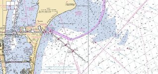
What I am looking for is a CHART like what wreckdiver1715 posted that has the depth of the water and the shore line of the islands.
If those that have this type of chart of the East coast of Florida could you take a photo of that chart and send it to me. I will then put it on a CD and have it enlarged to the size I need to work with. I also ask that you NOT post it here because somewhere it loses something that I cannot explain this at this time but it does.
A photo does not lose anything but a scan does.
Thanks
I am ready to get serious.
Peg leg
 

rgecy

Bronze Member
Jun 14, 2004
1,910
59
Beaufort, SC
Detector(s) used
Garrett Sea Hunter Mk II
PegLeg,

Have you been to the NOAA site to download the RNC charts. These are the charts you are looking for. You can download the charts and view them using one of th free viewers that are available from several different software vendors listed.

http://nauticalcharts.noaa.gov/mcd/Raster/resources.htm

NOAA also provides an online viewer.

http://ocsdata.ncd.noaa.gov/OnLineViewer/

This should solve your charts issues. You can print them if you like. If you want the actual charts, you can get them at your local WalMart.

Hope this helps.

Robert in SC
 

rgecy

Bronze Member
Jun 14, 2004
1,910
59
Beaufort, SC
Detector(s) used
Garrett Sea Hunter Mk II
Here is screen shot of the charts downloaded from NOAA. These are the exact same type charts Wreckdiver showed, but in digital format.

Robert in SC
 

Attachments

  • chart.jpg
    chart.jpg
    148.8 KB · Views: 606
OP
OP
P

Peg Leg

Bronze Member
May 29, 2006
1,520
5
Rgecy,
I thank you for the information. My wife wirks fir WALLYWORLD for over 14 years and when I showed the charts you posted she said SURE WE HAVE THOSE ??? SHE IS GOING TO PICK UP A FEW TOMMOROW.
She said that she did not know what I was looking for (for several months now) she has actully go into West Marina with me to look for charts.
I kept my mouth shut :'( :'( for a change
Thanks
Peg Leg
 

DennisB

Full Member
Jun 13, 2006
225
3
Clinton Twp Michigan
Detector(s) used
Garrett's Ace 250, Bounty Hunter Gold Digger
Primary Interest:
All Treasure Hunting
Does walmart carry charts for all locations or just local.

Thanks

Dennis
 

rgecy

Bronze Member
Jun 14, 2004
1,910
59
Beaufort, SC
Detector(s) used
Garrett Sea Hunter Mk II
Typically just local. But you can order them for most any location off the net or via a local marine supply.

Robert in SC
 

elistepp

Jr. Member
Feb 1, 2007
99
0
O.K. everyone,
I have a dumb question. Are the numbers on the chart the water depth? Very new and very interested in shipwrecks and I am going to Vero Beach in June for my first MD experience. My first time actually going to the ocean in fact. Anyone have any experiences that they would like to share about the vero beach/sebastian area? I just love this site and hearing and seeing all of the neat shipwreck pics!!!

Eli
 

OP
OP
P

Peg Leg

Bronze Member
May 29, 2006
1,520
5
Wreckdiver1715,
I hate to disagree with you my friend but there is ONE that I know of. In fact I have a piece of it sitting on my shelf. It is a piece of metal encrusted with cemented coral that has been estimated to be around 300 PLUS years old.
Can't say anymore right now but I want to add a little note here.
There is a 6 cannon ship 1 mile North of the Lighthoues is about 10' of water and onlt about 300 feet off shore. It is loaded with silver bars. This I know for a fact because I recovered about 600 pounds of silver bars. I was alsao arrested and spent 48 hours in a Federal lockdown along with 2 of my buddies. I lost everything execpt the clothes I had on.
It seems that the Government was buying this land for the Space Center UNKNOWN to the Landowners that there were planning to build the Space Center (they had different people buying everything they could get at a cheaper price).
Anyway when we came ashore with our jon boat filled with the silver bars TROOPS came over the sand dunes and surrounded us with guns DRAWN. THEY TOOK EVERYTHING. When I was released I asked WHAT ABOUT THE BARS. They responded WHAT BARS?
Before we were alowed to leave we all had to sign an AGREEMENT that we would not say a word about this for 10 years. I was only 17 at the time. That was 53 years ago so I guess I am safe now???
I would bet the ship is still there.
Yes Sir, there IS Treasure off the Cape.
Peg Leg
 

rgecy

Bronze Member
Jun 14, 2004
1,910
59
Beaufort, SC
Detector(s) used
Garrett Sea Hunter Mk II
The numbers on the chart can indicate feet or fathoms. Most charts that show inland rivers and shallow coastal area are typically in feet, but can be in fathoms. Its always best to check the chart legend if its in question. One of the other members here found this out when he was looking at a wreck in 1500' of water when he found out it was actually showing fathoms. The wreck was over 9000' deep!

Robert in SC
 

Salvor6

Silver Member
Feb 5, 2005
3,755
2,169
Port Richey, Florida
Detector(s) used
Aquapulse, J.W. Fisher Proton 3, Pulse Star II, Detector Pro Headhunter, AK-47
Primary Interest:
Shipwrecks
Peg, I concur. I will be one mile north of the lighthouse, 300' offshore, in 10' of water tomorrow with my blower boat to look for the other 300lb. of silver. If I find it, i'll split it with you 50/50!
 

macblastr

Jr. Member
Oct 17, 2006
68
3
Central Florida
Detector(s) used
excalibur 1000, 1280x, impulse
umm i believe you wouldnt make it 1/8th of a mile towards the cape... as soon as you turn north out of port canaveral you will have 2 bright orange dinghys with 2 honda 200's and a 50 cal mounted on the bow... then the choppers will arrive on scene... they have bigger guns.

just a heads up... i live here and there is a sign that is 30 feet wide that scrolls across "absolutely no one can go north out of the port, violators will be imprisioned and fined up to 50,000".. i think they are trying to say something.

anyone got a sub i can borrow?
 

mad4wrecks

Bronze Member
Dec 20, 2004
2,263
107
Detector(s) used
Aquapulse, DetectorPro Headhunter, Fisher F75
Primary Interest:
Shipwrecks
If I want to sail north up the coast of Florida, how far offshore do I have to stay from the Cape?
 

Salvor6

Silver Member
Feb 5, 2005
3,755
2,169
Port Richey, Florida
Detector(s) used
Aquapulse, J.W. Fisher Proton 3, Pulse Star II, Detector Pro Headhunter, AK-47
Primary Interest:
Shipwrecks
Of course I'm just joking!
 

OP
OP
P

Peg Leg

Bronze Member
May 29, 2006
1,520
5
Well this is NOT a joke.
What if you were to locate a British Man O War off the East coast of Florida.
Would this not come under a different Law and even if you had a permit/Lease would you be allowed to recovery some artifacts?
YES I knew that Pete was joking
Peg Leg
 

Skimmer

Full Member
Nov 2, 2006
152
0
Hi Guys-
Hey, I just want to say that as some of you already know, the security force at Canaveral is serious and DOES NOT fool around. Incidents that occur there don't get printed in the paper or anywhere else either.
I was contracted through Harbor Branch Oceanographic in 1999 to do an underwater survey in
the "turning basin" on Canaveral (where the subs come in to be reloaded/offloaded with ballistic nukes). We were escorted in and shadowed 100% of the time by three security craft, and had 2 very unlikable armed guys aboard my trawler the entire time, even though I had a Final Secret clearance done prior to this. The reloading of the subs is done in a building with what looks like 4 giant tampon applicators sticking out of the top of it. i believe that since that time most of the sub activity has been moved to St. Marys, GA. The survey took 3 days and I was really glad to get out of there!
 

wreckdiver1715

Bronze Member
May 20, 2004
1,721
151
Satellite Beach
Detector(s) used
Minelab Excal 1000
Primary Interest:
All Treasure Hunting
Even Bob Marx said that there were no wrecks off of the Cape, when questioned during one of his talks last summer in Cocoa Beach. Of course, we all knew he was joking as well.

Tom
 

Top Member Reactions

Users who are viewing this thread

Top