French fleet of 1565

Jolly Mon

Hero Member
Sep 3, 2012
868
631
Primary Interest:
All Treasure Hunting
I must be dense or something...
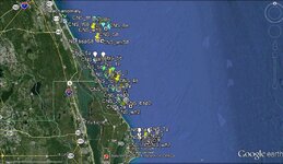
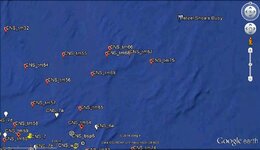
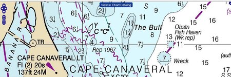
They got over 200 anomalies on this expedition, but were only able to pinpoint one of them with a hydroprobe, so there is nothing possibly shipwreck related about the other 200 or so mag hits ???

I agree with SmithBrown that there was probably quite a bit of iron aboard La Trinite..." A significant amount of munitions, armament, and supplies are listed on its 28 April 1565 manifest (Armstrong 2001:123-132). Iron objects which are likely preserved include 20 berches (large faucons or falcons, a class of cannon) (Guérout 2011), four chiens (another artillery class), 977 cannon balls, 300 iron pikes, 1,300 nails, 100 corsets of armor, 3,153 pounds of stock iron, two anvils, a large iron bowl, a sheet of iron, and a variety of small items including tongs, hooks, pincers, and other hand tools."

Even so, these items might well be well scattered and the heavier objects, especially, might be very, very deeply buried.

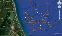
Apparently back in 1994 the beach front was magged with an ATV and a additional 345 anomalies were located...I am not privy to whether any of these targets were ground truthed (probably awfully tough to do), but the report indicates the survey team believed as many as 16 sites on the beach may have been shipwreck related. :dontknow:

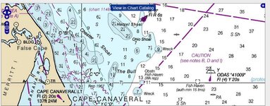
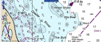
The general area in question shows an accretion rate of around 2 feet per year on the beach front from 1873 to 1969. Assuming that rate has stayed more or less constant over the years, that is potentially a lot of sand. When you consider the area from around Sebastian Inlet south to Wabasso Beach has averaged -1 to -2 feet of erosion over the same period, obviously there is potentially quite a different dynamic involved.

I guess we won't know until some of the anomalies found on this survey are actually ground truthed...perhaps more grant money is needed...:tongue3:
 

ScubaFinder

Bronze Member
Jul 11, 2006
2,220
528
Tampa, FL
Detector(s) used
AquaPulse AQ1B - AquaPulse DX-200 Magnetometer
Primary Interest:
Shipwrecks
I read it as 200 Probes, could have been twenty or thirty probes on one target. Still, even the best mag operators can only get you so close to the target. Every time the boat makes a course correction, the lay-back algorithm looses accuracy. I would never rely on a probe to try to hit the targets. So many factors, if the item sat on top of the sand for a bit before being swallowed up, it could have a calcium carbonate encrustation on it, how would you distinguish that from hard pan with just a probe. The whole ideology is just not a practical way to go about verifying mag targets. Who knows, maybe they mean the fuel tank from the shrimp boat was the only shipwreck material they found. The way it was written it sounds like they probed 200 times and only hit metal once.

I just got a good laugh out of the statement "Well, at least we know the technique is right".
 

Jon Phillips

Hero Member
Mar 10, 2009
535
326
Riverview Florida
🥇 Banner finds
1
Detector(s) used
F-75, MXT, 6000di sl
Primary Interest:
All Treasure Hunting
I want to give them some benefit of the doubt....that story has been filtered through the uninformed media, and the whole deal might not have been as bad as it sounds....

That being said...I still don't agree with the whole "top secret" aspect of the whole deal....

They all act like treasure hunters/metal detectorists are the scourge of history...but those sites wouldn't have been known without them, and the only destruction of anything has come under government heavy equipment!
 

Jolly Mon

Hero Member
Sep 3, 2012
868
631
Primary Interest:
All Treasure Hunting
Maybe the whole idea is to do a survey with a boat towed, use the handheld mag to pinpoint and hope to get lucky with the hydroprobe ?

I would like to see the survey they just did along side a map of the beach hits they got back in the 90's...
 

signumops

Hero Member
Feb 28, 2007
756
226
U.S.
Detector(s) used
Garrett, Minelab, Aqua-Pulse
Primary Interest:
All Treasure Hunting
BTW, using a 'hydro probe' per se, is not necessarily a bad idea if you couple the concept with cathodic testing. Cathode metrics are commonly used in the offshore oilfield to test the integrity of platform structures below the waterline. When I worked for Oceaneering many years ago, we did substantial amounts of work performing cathodic tests. The concept is simple: put some water in a glass/plastic bowl; put a nickle, a penny and a silver dime in the water (not touching one another); use any OTS ohm meter, set on minimal threshold resistance and place one lead in the bowl (not touching any of the coins); then put the other lead in the water observing the meter; when the meter settles, touch one of the coins to see the cathodic effect, which will differ with the content of the coins. Pour some salt in the bowl and you will see the effect of the accelerated polarization (maybe not the correct term here...). At any rate, if you can actually reach a buried object and induce a water column, and poke it with a lead to make a ground, you would be able to determine if, in fact, you had reached a metal object. The problem would be establishing a ground on an iron object covered with concretions and rust, however, any cathodic measurement at all would be enough to merit excavation, if possible.

John Stiner, the archaeological tech at the Canaveral National Seashore told Dr. Bob Baer and myself that nothing was found along the seashore after the mag study of the beach, aside from old car(s). See page 211 of "West Of The Bull", Signum Ops. Can somebody out there on this thread tell me if this advice from Stiner was deliberate obstruction?
 

Jon Phillips

Hero Member
Mar 10, 2009
535
326
Riverview Florida
🥇 Banner finds
1
Detector(s) used
F-75, MXT, 6000di sl
Primary Interest:
All Treasure Hunting
While we are on the subject...Some reading this might appreciate these pictures...some are well known, but this is a cool edition of this story....

Artifacts 057.JPG


Artifacts 058.JPG


Artifacts 059.JPG


Artifacts 060.JPG


Artifacts 061.JPG


Artifacts 062.JPG


Artifacts 063.JPG


Artifacts 064.JPG


Artifacts 065.JPG


Artifacts 066.JPG


Artifacts 067.JPG


And then this one....not seen so much....and why you NEVER want to be on the losing end of a 16th century Florida, Indian battle!!


Artifacts 068.JPG
 

Jolly Mon

Hero Member
Sep 3, 2012
868
631
Primary Interest:
All Treasure Hunting
I read the report detailing LAMP's methodology.

The plan was to use a towed mag for an initial survey, then return and pinpoint the detected anomalies with a handheld mag and hope to be able to recover some identifiable artifacts through the use of the probe and dredge.

At no time was anything more than very limited excavation planned.

I cannot speak to any possible deliberate obstruction by Federal employees regarding targets detected on the terrestrial survey...indeed LAMP's report states that as of January, 2013 NO excavation was carried out on any of those targets. This strikes me as nearly unbelievable, frankly.

Something about the whole "secrecy" aspect of this project gets in my craw.

While the project may have been paid for primarily by LAMP and other private organizations, there is no doubt that Federal Agencies (NPS, SEAC, SRC), as well as property under claimed Federal jurisdiction are involved.

I just filed 2 FOIA requests with the Dept. of the Interior.

The first is for complete results and maps of the terrestrial mag survey conducted by NPS archaeologist David Brewer back in 1994.

The second is for complete results and maps of the mag survey just completed by LAMP. This survey was conducted in areas claimed by NPS to be under Federal jurisdiction and was materially aided by NPS employees and its agencies.

We will see.

I'll keep the board posted on the results...
 

Salvor6

Silver Member
Feb 5, 2005
3,755
2,169
Port Richey, Florida
Detector(s) used
Aquapulse, J.W. Fisher Proton 3, Pulse Star II, Detector Pro Headhunter, AK-47
Primary Interest:
Shipwrecks
Good luck Jolly Mon. I doubt if you will get anything but please keep us posted.
 

Jolly Mon

Hero Member
Sep 3, 2012
868
631
Primary Interest:
All Treasure Hunting
Good luck Jolly Mon. I doubt if you will get anything but please keep us posted.

Double good luck, I hope you get some good info........

I will keep the forum informed as to any progress...or lack thereof...

I actually have my own selfish reasons for being interested in the data, over and above disliking the cloak and dagger aspect of the whole operation.
 

Jolly Mon

Hero Member
Sep 3, 2012
868
631
Primary Interest:
All Treasure Hunting
Just a quick update.

I filed two separate FOIA requests back on Aug 27th and over the next couple of days received perfunctory emails from the NPS stating that my requests had been received and forwarded to SEAC as they were the responsible agency.

I got no response for the next two months and so decided to attempt to get an update on the status of my requests (Oct 30th).

On Oct 31st. I received this response from the NPS: "The final response has to be reviewed by our Solicitor's Office and it is in their hands. As soon as I get it back from them, I will complete your request. I will check with the responsible attorney today to find out how much longer it will be until she can get it back to me."


It sounds like the archies and bureaucrats on the government payroll are going to play hardball and try to keep information you paid for a secret...

I did a little research into these FOIA requests because I know nothing about the process. If the guidelines agencies are supposed to follow are any indication, then NPS's handling of my requests has been highly unusual. Apparently, I was supposed to receive a final determination or a reason for a delay within 20 days of the original request. I got nothing for two months and I had to ask even for that.

Here is a copy and paste from the Q&A section of the FOIA advocates website:

Q. What are the time frames for the government to respond to a request for public records?
A. Generally, under FOIA, the agencies are required to issue a final determination within 20 working days of receipt of the initial request or appeal. However, this can be extended by ten days in "unusual circumstances" such as unforeseeable backlogs or other processing problems. 5 U.S.C. § 552(a)(6)(B). State laws have differing time limits, but most apply at a minimum, a "reasonable time" standard.

Q. What if the government fails to timely respond to a FOIA public record request?
A. You have been deemed to have exhausted your administrative remedies, and may immediately seek judicial review in federal court. 5 U.S.C. § 552(a)(6)(C)(i).


There are only 9 valid reasons for an agency to deny a request... FOIAdvocates - Freedom of Information Requests/Appeals/Litigation...

From what I can tell, none of these could possibly apply to the mag data I requested...

It sounds like NPS's refusal to make a final determination on my requests in a timely manner already makes them subject to judicial review in federal court.

I can't wait to hear the legal obfuscations from the government lawyers ...
 

Last edited:

signumops

Hero Member
Feb 28, 2007
756
226
U.S.
Detector(s) used
Garrett, Minelab, Aqua-Pulse
Primary Interest:
All Treasure Hunting
Hats off to you for the attempt. They probably don't have any data anyway. I think the whole adventure was a knee jerk response of brinksmanship. They covered themselves in the very beginning by claiming they would keep all of their finds a secret. FOIA is a tool that only applies to federal data. Trying to encompass LAMP acquired information under the FOIA blanket will be difficult or impossible. But a great precedent is in the offing: Since NPS claims the submerged land next to the Canaveral National Seashore, then they must ultimately have control over the data they permitted LAMP to collect. A court hearing may be your only avenue of relief.
 

Jolly Mon

Hero Member
Sep 3, 2012
868
631
Primary Interest:
All Treasure Hunting
But a great precedent is in the offing: Since NPS claims the submerged land next to the Canaveral National Seashore, then they must ultimately have control over the data they permitted LAMP to collect.

This is exactly why I filed requests for LAMP's data as well as the old Brewer data. I think a comparison of the anomalies of the two surveys would possibly be fascinating, but I am also curious to see what their rationale will be for a denial of either.

There is no doubt NPS allowed LAMP to make the offshore survey. In fact, they materially aided the survey. The NPS must have the LAMP data (NOAA probably has it too). As far as I can tell, the only rationale NPS can possibly use to deny making the data available through a FOIA request is an invocation of the need for the protection of an "archaeological site" eligible for protection as a National Historical Site. The problem is, that angle can't possibly be used in this instance or at least not in toto. They could deny Brewer's data in regards specific sites, say the Armstrong site, for instance, but not for the total beach survey or the offshore survey in which, apparently, nothing has been found.

The NPS claim to jurisdiction over state sovereign submerged lands a curious thing...I am not sure of the nature of its legal basis.
 

Last edited:

Jolly Mon

Hero Member
Sep 3, 2012
868
631
Primary Interest:
All Treasure Hunting
I received a certified letter from the United States Department of the Interior concerning my FOIA requests.

Their response concerning the LAMP mag survey of the waters off Canaveral National Seashore: "The work performed in 2014 has not yet been turned over to the NPS in a final synthesized report nor does NPS posses the raw data. You are welcome to submit another request at a later date when the report has been finalized and is in possession of NPS."

Concerning the Brewer mag survey of the beachfront, I received a 211 page report on CD entitled A Beach Face Magnetometer Survey at Canaveral National Seashore, dated December, 1988. The only problem is that they redacted 202 of the 211 pages !!!

They do not reveal the location of a single mag hit...basically, the only information not redacted is the typical mumbo jumbo contained in the beginnings of these government documents.

They claim they are withholding the data under Section 9 of the Archaeological Protection Act of 1979. This is nonsense because NPS has stated that no excavations have been carried out on any of the Mag hits of that survey. By definition in Section 9, an archaeological resource must be in excess of 100 years old. This is a Federal Statute, not a Florida State Statute. Needless to say, I am filing an appeal. Basically, they are classifying every mag hit on the beachfront as an archaeological resource, despite the fact they claim that NONE have even been excavated !!!

There was one interesting tidbit in the few pages of the report they did not withhold:

NPS admits they know of two shipwrecks within the area of interest. One they simply refer to as a modern, steel barge. All information on the other wreck has been blacked out. The Armstrong Site is mentioned, but not by name...and no further information is given...
 

signumops

Hero Member
Feb 28, 2007
756
226
U.S.
Detector(s) used
Garrett, Minelab, Aqua-Pulse
Primary Interest:
All Treasure Hunting
Tell them you have done your own survey before they took over, and see if they will trade data with you. Actually, that was done by Fay Feild and Mel Fisher. The data might still be available at the Mel Fisher Center.
 

Jolly Mon

Hero Member
Sep 3, 2012
868
631
Primary Interest:
All Treasure Hunting
John Stiner, the archaeological tech at the Canaveral National Seashore told Dr. Bob Baer and myself that nothing was found along the seashore after the mag study of the beach, aside from old car(s). See page 211 of "West Of The Bull", Signum Ops. Can somebody out there on this thread tell me if this advice from Stiner was deliberate obstruction?

I might try the approach you suggested later, but at first I am just going to use the language of the statues against them.

There is very little doubt about one thing, though: Mr. Steiner is either completely clueless or is playing somewhat loose with the facts as far as the mag survey is concerned...

Brewer, page 3.png
 

signumops

Hero Member
Feb 28, 2007
756
226
U.S.
Detector(s) used
Garrett, Minelab, Aqua-Pulse
Primary Interest:
All Treasure Hunting
The Barge is easy. The other wreck he is speaking of is a shrimper. Meanwhile the remaining 300 plus hits could be very interesting to map.

I don't think Stiner really cares about any shipwrecks at Canaveral Nat. Seashore, one way or the other.
 

Red_desert

Gold Member
Feb 21, 2008
6,850
3,500
Midwest USA
Detector(s) used
Garrett Ace 250/GTA 1,000; Fisher Gold Bug-2; Gemini-3; Unique Design L-Rods
Primary Interest:
All Treasure Hunting
Canaveral National Seashore Record of Decision is Released
Release Date: Immediately
Date: November 7, 2014
Contacts: Myrna I Palfrey–321-267-1110

Canaveral National Seashore Superintendent Myrna Palfrey has announced the release of the Record of Decision for the Final General Management Plan and Environmental Impact Statement for Canaveral National Seashore. This plan represents involvement from our park communities, members of the public, state agencies of Florida, other agencies and partners, and the National Park Service.

http://www.nps.gov/cana/parknews/upload/CANA-ROD-Press-Release-11-7-2014.pdf
 

Last edited:

Red_desert

Gold Member
Feb 21, 2008
6,850
3,500
Midwest USA
Detector(s) used
Garrett Ace 250/GTA 1,000; Fisher Gold Bug-2; Gemini-3; Unique Design L-Rods
Primary Interest:
All Treasure Hunting
"the National Park Service to select and implement Alternative B from the
Final General Management Plan and Environmental Impact Statement. Under this
alternative, the national seashore would be managed
to preserve and enhance the natural and historic landscape features
associated with the national seashore’s eastern Florida
coastal barrier island system."


Of course, the decision to limit developement in CNS, probably doesn't affect ship salvage but preserve archaeological sites on land. CNS takes in a good stretch of shoreline.
 

Attachments

  • CNS_shoreline1-8.jpg
    CNS_shoreline1-8.jpg
    132.6 KB · Views: 107
Last edited:

Red_desert

Gold Member
Feb 21, 2008
6,850
3,500
Midwest USA
Detector(s) used
Garrett Ace 250/GTA 1,000; Fisher Gold Bug-2; Gemini-3; Unique Design L-Rods
Primary Interest:
All Treasure Hunting
I've used the free online nautical charts before, but it took me a while to figure out which chart for CNS. One chart starts at The Bull going north. Another I looked at is below it going south. You need to zoom in a lot.

This is the main page for Atlantic side of Florida.

Atlantic NOAA Nautical Charts

Here is Charleston Light to Cape Canaveral. At the very bottom is The Bull. After zooming in, the map will drag using an external mouse. Not much is shown on the shoreline, so it might help to use a land topo also, to find your landmarks on shore. Then you might be able to match things up with GE.

Chart 11480
 

Attachments

  • CNS_nautical1.jpg
    CNS_nautical1.jpg
    252.4 KB · Views: 90
  • CNS_6N.jpg
    CNS_6N.jpg
    77.9 KB · Views: 91
  • CNS_nautical1B.jpg
    CNS_nautical1B.jpg
    267.4 KB · Views: 92
  • CNS_nautical1C.jpg
    CNS_nautical1C.jpg
    223.5 KB · Views: 81
  • CNS_7.jpg
    CNS_7.jpg
    129.5 KB · Views: 86
Last edited:

Top Member Reactions

Users who are viewing this thread

Top