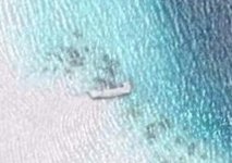
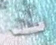
Neat picture. But..wouldn't that have been beach a couple hundred yrs. ago?
I know there's something out there. Having written this, I remember that a wreck was actually on New Smyrna Beach, and was destroyed by worker on a backhoe, so it is indeed probable. Find anything..I won't tell....
never thought about it being a junk
the coords are
5°47'0.46"N
157°10'0.73"E
if it turns out to be a treasure ship full of gold don't forget my share....
When I first looked at this I thought it was under water but according to the wave pattern it is only about half under water or maybe a little more than half.
Very interesting never the less.
The water is very very clear.
Peg Leg
how old are these sattelite photos? i put in my house coordinates and it just shows the land before the house was built and also it doesnt show the new construction that is a little over a year old now. Do they make this program where you can get instant up to date images?
thanks,
malady
only areas of interest to homeland security are updated.like hurricane damage,wars zones etc.before google bought out earthview i talked to the owner,he said the images were updated every 18 months.there are sat sites that have current images,some have samples but are never what you are looking for.you have to pay alot for them or subscribe to thier service.news agencies do this,they can afford the 5k or more a year.many years ago i worked somewhere near wash DC.it was my job to look at current sat photos to find certain objects.thats all i can say.