- Jun 3, 2007
- 1,188
- 1,994
- Detector(s) used
- A sharp eye, an AquaPulse and a finely tuned shrimp fork.
- Primary Interest:
- Shipwrecks
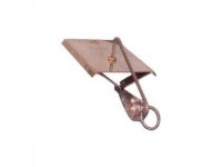
stevemc said: "They made a strain relief and motion shock absorber by making a big loop, and having 2 places that were securely attached to the cable, and a thick rubber piece like a rubber bungee hooked in there to flex."
and that good idea will be put into use next time we head out.
Thanks, Steve!
and that good idea will be put into use next time we head out.
Thanks, Steve!