Early Florida maps, shipwrecks, &

ARC

Gold Member
Aug 19, 2014
37,248
131,546
Tarpon Springs
Detector(s) used
JW 8X-ML X2-VP 585
Primary Interest:
All Treasure Hunting
conquistadors_ct000342-crop.jpg
 

ARC

Gold Member
Aug 19, 2014
37,248
131,546
Tarpon Springs
Detector(s) used
JW 8X-ML X2-VP 585
Primary Interest:
All Treasure Hunting
Actually Alex... I will take anything rare and prior to 1800.
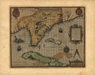
 

TRG

Full Member
May 22, 2017
177
235
Arizona
Primary Interest:
Shipwrecks
It's possible to overlay these on GoogleEarth as a transparency and stretch them to kind of fit for some entertainment. Other software using control points will do a better job of fitting the maps.
 

smallfoot

Bronze Member
May 29, 2019
1,970
4,144
Flawda
Detector(s) used
Garrett AT Pro, Bounty Hunter Tracker IV
Primary Interest:
All Treasure Hunting
1591
 

Attachments

  • florida 1591.jpg
    florida 1591.jpg
    82 KB · Views: 113

smallfoot

Bronze Member
May 29, 2019
1,970
4,144
Flawda
Detector(s) used
Garrett AT Pro, Bounty Hunter Tracker IV
Primary Interest:
All Treasure Hunting
1775
 

Attachments

  • 1775 Florida.jpg
    1775 Florida.jpg
    358.9 KB · Views: 123

MPH200

Sr. Member
Oct 26, 2012
425
677
Austin, Texas
Detector(s) used
Minelab Explorer SE
Primary Interest:
Shipwrecks
Thank you. Any Gulf of Honduras / British Honduras - specifically looking at Belize / Ambergris Caye area would be appreciated.
I have quite a few but always willing to add.
 

BillA

Bronze Member
May 12, 2005
2,186
3,218
Drake, Costa Rica
there seems to be a gathering of map peeps,
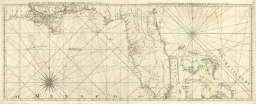
so am looking for a med sized image of Dampier's "A Map of The Middle Part of America" (1729 ?)
I cannot find a larger one, Thanks
 

Last edited:

Red_desert

Gold Member
Feb 21, 2008
6,844
3,494
Midwest USA
Detector(s) used
Garrett Ace 250/GTA 1,000; Fisher Gold Bug-2; Gemini-3; Unique Design L-Rods
Primary Interest:
All Treasure Hunting
In English...

[FONT=Verdana,Arial,Tahoma,Calibri,Geneva,sans-serif]The Marine Charter could be considered the world's first printed nautical map.
It is a huge map made by the German cartographer Martin Waldseem-ller in 1516, at a key moment when there was talk of a new land but few knew what it was like.
The 1516 Marine Charter shows for the first time a drawing of the outline of the world as close to what we know today.
It includes a deformed American continent, hundreds of sea routes, and geographic information that was not previously known on other maps.
This Charter is a continuation of another famous map of the Waldseem-ller himself, which in 1507 he created and which is marked as the birth certificate of America, because it was the first time that the continent received that name.
[/FONT]
 

Top Member Reactions

Users who are viewing this thread

Latest Discussions

Top