ask me your 1715 fleet questions,,,,,see if i can answer em

Denniss

Full Member
Jan 7, 2011
207
229
Fort Pierce, FL
Detector(s) used
Fisher CZ-21, Fisher Impulse, Gold Bug II
Primary Interest:
Shipwrecks
Yes, that is the legal answer, but any old stories, found items, timbers, the evidence they are there is the question.

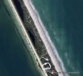
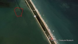
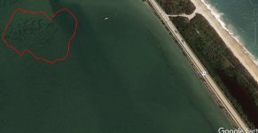
Marx in one of his lectures mentions his divers recovering coins from one of the lakes/ponds adjacent to A1A. He said that some of his divers got sick after diving there, so they stopped, looks like a great place for Vibrio to grow. Whether the coins washed there or were part of a stash carried by a survivior, who knows. Whether there are coins in the adjacent water would be a good project for someone with a snorkel and a metal detector willing to talk to the marine patrol. "I was just looking for rings and watches the wading fishermen might have lost"
 

Attachments

  • Mclartey.JPG
    Mclartey.JPG
    58.8 KB · Views: 52
Last edited:

Denniss

Full Member
Jan 7, 2011
207
229
Fort Pierce, FL
Detector(s) used
Fisher CZ-21, Fisher Impulse, Gold Bug II
Primary Interest:
Shipwrecks
I'm sure this has been looked at by someone. Has anyone checked it out. Probably just rubble but it is in an interesting location
 

Attachments

  • Mclartey1.JPG
    Mclartey1.JPG
    45.7 KB · Views: 53
  • Mclartey2.JPG
    Mclartey2.JPG
    96.3 KB · Views: 57
Last edited:
OP
OP
ivan salis

ivan salis

Gold Member
Feb 5, 2007
16,794
3,809
callahan,fl
🏆 Honorable Mentions:
1
Detector(s) used
delta 4000 / ace 250 - used BH and many others too
ok to the best of my ability to figger out from the reading of various archived reports and various old maps --- as the storm was coming upon the combined 1715 fleet ( 11 Spanish vessels (five in Ubilla's fleet and six in Echeverz's fleet) and the French grifon --a total of 12 ships --the grifon broke away first well before any of the others --being much lighter loaded it went rapidly northward then cut eastward --the storm walked up the coast (similar to the way many modern storms still do today) --thus the storm was behind the grifon as she had cut eastward by the time storm gained on her , thus she avoided the storms effects and survived ---- of the Spanish ships --Ubilla being in overall charge of the combined fleet and thus accountable for the kings treasure vessels all 4 of them ordered Echeverz to have the two royal treasure vessels in his fleet to join up with Ubilla's fleet --Echeverz was not happy at all about it but had no choice but to comply -- Echeverz also ordered the smallish dutch prize in his fleet to join into Ubilla's fleet --thus there was 8 vessels in the group that sank close together --- there was 3 vessels of Echeverz's fleet that were not subject to Ubilla's command --because they were not carrying "royal cargo" --they were told by Echeverz to separate from the fleet and survive as best they could --they were THE CONCEPTION , THE TOBBACO HAULING NAO SAN MIGUEL AND THE FRENCH PRIZE VESSEL KNOWN AS EL CIERVO --it was reported that the Conception sank somewhere near the cape as 4 survivors were report found after floating on a hatch cover for 2 days in the cape area * ---in salmon's report to the king of Spain dated sept 20 1715 --it states that 9 vessels are known to be sank --(that would be the 8 vessel that sank as a group and the conception) and 2 of the gallones are missing ( Echeverz's fleet was known as "the gallons de terra firme" thus it was the Nao San Miguel and the El Cievro he was speaking of) but are feared sank upon the sea as wreckage of a large vessel or vessels was found upon the north shore of St Augustine note the 1728 dutch map which says in dutch --" here lies he remains of the 1715 fleet " off of Matanzas which I think is where one of missing vessels (El Cievro) may have sank trying to make safe harbor in St Augustine before the storm overtook them --they failed

one might be wrecked near melborne * I think it could be the San Miguel but not sure

this is the quickie ivan's cliff notes version
 

Last edited:

WaveJunky757

Jr. Member
Jan 31, 2018
90
153
Virginia Beach
Primary Interest:
All Treasure Hunting
Following the deep water theory, any assumptions on how far out the 3missing ships made it ? It would be interesting to know what latitude the Griffon turned, did the other 3 turn with her? How much faster could they have been compared to the other ships, a few Knots? They would have been at the mercy of the wind and waves and not a reef. I’ve heard some mention that they could have made it up to Georgia waters.
 

Jason in Enid

Gold Member
Oct 10, 2009
9,593
9,229
Primary Interest:
All Treasure Hunting
Following the deep water theory, any assumptions on how far out the 3missing ships made it ? It would be interesting to know what latitude the Griffon turned, did the other 3 turn with her? How much faster could they have been compared to the other ships, a few Knots? They would have been at the mercy of the wind and waves and not a reef. I’ve heard some mention that they could have made it up to Georgia waters.

I dont think anybody can make anything more than the grossest guess. Even if we knew exactly where they turned eastward, there are just too many other unknowns.

Where was the eye of the storm?
What was the track of the storm?
What were the wind speeds?
What direction were the seas running?
How much extra weight (like cannon, etc) were being dumped?

Since the sailing ships back then were little more than over-grown bathtub toys, they were much more at the mercy of the seas. They could have turned out only to be overrun by the storm and sunk in the bahama channel. They could have gotten out only to be blown back into the shore farther north. Maybe they turned out and had the storm pass below them, letting the back-side winds blow them back towards the shore south of the main fleet. And then you have the current to consider... If they simply sank instead of being beaten on the coast like the rest, you have intact (or mostly) intact hulls on the bottom and the current can move sunken boats for miles. Imagine something like the Atocha trail, off the east coast, just spilling its content for mile after mile.

So look at that situation from a prospecting eye. The ships turn east but are getting beaten to death by wind and waves. Sheets are gone, maybe even the masts too. They are pumping water as fast as possible trying to outlast the storm. The capt orders all the extra weight dumped to stay afloat, so the cannons go over and then the shot, probably lots of barrels of goods too, maybe even the anchors. That buys them hours of life and likely miles of distance, but in the end they still sink. Only now what is left of the ship to find? If the cannon, anchors and other large items are miles away, your mag is almost useless. If the treasure is scattered your detector is useless. You are looking for the proverbial (golden) needle in a pile of needles, and youre blind.
 

liverock

Full Member
May 23, 2008
110
117
Great assessment and research.

We found most of a mast just in front of satellite high school in 1961....was digging a fire pit.... on the beach, hit this huge old mast.... I ran up to our house and Dan Thompson was home...we lived in a duplex on base.......we took the family and Dan back and dug it up......Aquanaut here cleaned up the pick as it was a really old slide....
 

ARC

Gold Member
Aug 19, 2014
37,272
131,682
Tarpon Springs
Detector(s) used
JW 8X-ML X2-VP 585
Primary Interest:
All Treasure Hunting
I dont think anybody can make anything more than the grossest guess. Even if we knew exactly where they turned eastward, there are just too many other unknowns.

Where was the eye of the storm?
What was the track of the storm?
What were the wind speeds?
What direction were the seas running?
How much extra weight (like cannon, etc) were being dumped?

Since the sailing ships back then were little more than over-grown bathtub toys, they were much more at the mercy of the seas. They could have turned out only to be overrun by the storm and sunk in the bahama channel. They could have gotten out only to be blown back into the shore farther north. Maybe they turned out and had the storm pass below them, letting the back-side winds blow them back towards the shore south of the main fleet. And then you have the current to consider... If they simply sank instead of being beaten on the coast like the rest, you have intact (or mostly) intact hulls on the bottom and the current can move sunken boats for miles. Imagine something like the Atocha trail, off the east coast, just spilling its content for mile after mile.

So look at that situation from a prospecting eye. The ships turn east but are getting beaten to death by wind and waves. Sheets are gone, maybe even the masts too. They are pumping water as fast as possible trying to outlast the storm. The capt orders all the extra weight dumped to stay afloat, so the cannons go over and then the shot, probably lots of barrels of goods too, maybe even the anchors. That buys them hours of life and likely miles of distance, but in the end they still sink. Only now what is left of the ship to find? If the cannon, anchors and other large items are miles away, your mag is almost useless. If the treasure is scattered your detector is useless. You are looking for the proverbial (golden) needle in a pile of needles, and youre blind.

UNLESS...

You have a map which depicts 2 of the wrecks approximate locations... made / documented years after the fact.

And those locations don't jive with any known wreck locations.

One word comes to mind...

Deep.

:)
 

Jason in Enid

Gold Member
Oct 10, 2009
9,593
9,229
Primary Interest:
All Treasure Hunting
UNLESS...

You have a map which depicts 2 of the wrecks approximate locations... made / documented years after the fact.

And those locations don't jive with any known wreck locations.

One word comes to mind...

Deep.

:)

Well, of course! If you have the X marking the spot, why arent you out there investigating? I would be!
 

WaveJunky757

Jr. Member
Jan 31, 2018
90
153
Virginia Beach
Primary Interest:
All Treasure Hunting
A map with “approximate” locations.... Not sure where to begin haha. Two scenarios, map made before technology or one produced with technology. In my opinion an old map with approximate locations would suggest the wrecks were visible from a landmass or a survivor(navigator) that knew exactly where they were was able to produce a location, then verified(salvage?). Great Thread everyone.
 

WaveJunky757

Jr. Member
Jan 31, 2018
90
153
Virginia Beach
Primary Interest:
All Treasure Hunting
I’d be curious to know how many survivor accounts there are in the archives, a few, a couple dozen, over a hundred? ... How many people were “interviewed” about what they know and saw. Those accounts are the eye into the past. The order in which the ships left should shed light onto things, I would think that would be common knowledge to some. 1-12 how they were going up the coast. Could some be further south ... hmm “Yee who can read the archives will be closest to the truth”
 

ARC

Gold Member
Aug 19, 2014
37,272
131,682
Tarpon Springs
Detector(s) used
JW 8X-ML X2-VP 585
Primary Interest:
All Treasure Hunting
A map with “approximate” locations.... Not sure where to begin haha. Two scenarios, map made before technology or one produced with technology. In my opinion an old map with approximate locations would suggest the wrecks were visible from a landmass or a survivor(navigator) that knew exactly where they were was able to produce a location, then verified(salvage?). Great Thread everyone.

Wellll just so you know.. in case you don't.

Some of the now known wreck locations were discovered annotated on a map in a book... and through that book / map / info they were found.
 

OP
OP
ivan salis

ivan salis

Gold Member
Feb 5, 2007
16,794
3,809
callahan,fl
🏆 Honorable Mentions:
1
Detector(s) used
delta 4000 / ace 250 - used BH and many others too
-made a mere 13 years after the 1715 fleets wrecking there was a sea chart made by a Dutchman --named Gerard Van Keulen in 1728 * that says in Dutch -"-here lies the remains of the silver fleet Ao 1715"{ .that map combined with salmon's sept 20th 1715 report in which he states " of the 2 missing vessels there is little doubt they sank up the seas since wreckage of a large vessel or vessels was FOUND on the NORTH SHORE OF ST AUGUSTINE" … a vessel sinking just south of St Augustine in a north bound hurricane would have debris float up on Anastasia island's southern end ...just slightly north of St Augustine

not 1 but 2 historical sources stating that a 1715 fleet vessel (or possible 2 vessels) sank near St Augustine --gotta make you go ---Hummm

the Spanish vessels broke away a day later than the much lighter loaded grifon --the grifon got out ahead of the storm by rapidly going northward then cutting due east --as the storm was approaching it thus by the time the storm caught up to it --the storm which was running along the coast was in effect "behind" her which explains how she survived the storm --the much slower heavily loaded 3 Spanish ships could not move fast enough to get far enough northward to break free of the storms effects and go eastward --they were in effect "pinned" by the storm on the east side and the shoreline on the west side so they sailed northward hoping to reach a port where they could go for safety --like say St Augustine --one by one the storm overtook and sank them
 

Last edited:

Salvor6

Silver Member
Feb 5, 2005
3,755
2,169
Port Richey, Florida
Detector(s) used
Aquapulse, J.W. Fisher Proton 3, Pulse Star II, Detector Pro Headhunter, AK-47
Primary Interest:
Shipwrecks
Ivan you are not the first one to discover Van Keulen's chart. Many other treasure hunters have searched that area and found nothing. Doug Pope of Amelia Research is currently searching that area.
 

ROBOTCOP13

Sr. Member
Jul 29, 2014
295
425
Primary Interest:
All Treasure Hunting
When did Elisabeth Farnese's specific jewelry request get communicated to the Viceroy of New World Spain?
She and the King were married by proxy on Sept 16, 1714 and they met in person on Dec 24, 1714.

Allowing for the time lag to communicate with the Viceroy (8 to 10 weeks?), time to make the jewelry (?), time to transport the jewels from (Mexico City ?) to Vera Cruz to board the fleet.

There should be quite a bit of documented evidence of this communication.
 

Jason in Enid

Gold Member
Oct 10, 2009
9,593
9,229
Primary Interest:
All Treasure Hunting
When did Elisabeth Farnese's specific jewelry request get communicated to the Viceroy of New World Spain?
She and the King were married by proxy on Sept 16, 1714 and they met in person on Dec 24, 1714.

Allowing for the time lag to communicate with the Viceroy (8 to 10 weeks?), time to make the jewelry (?), time to transport the jewels from (Mexico City ?) to Vera Cruz to board the fleet.

There should be quite a bit of documented evidence of this communication.


You mean the duchess of Parma?

deep-shaw-glass.jpg
 

OP
OP
ivan salis

ivan salis

Gold Member
Feb 5, 2007
16,794
3,809
callahan,fl
🏆 Honorable Mentions:
1
Detector(s) used
delta 4000 / ace 250 - used BH and many others too
the king of Spain was basically humping his dying wife (rather a gross thing to do) --when his ministers said to him that it was "bad form" to do so his reply was "well I do not know how long it will take you to find me another wife to have sex with "---needless to say -- when word of this spread around the courts of Europe ...it became very very hard to find a willing wife of noble blood line to marry the freak ….and if a king could not make a heir with the woman --he was entitled to divorce her basically leaving her broke and ruined ...thus the "dowery" a royal bride's insurance policy so she would have money to live on no matter what...and being she had to deal with a gross freak ….well be sure it was a "high price" indeed
 

Top Member Reactions

Users who are viewing this thread

Top