G.I.B.
Gold Member
- Feb 23, 2007
- 7,187
- 8,537
- 🏆 Honorable Mentions:
- 1
- Detector(s) used
- CTX 3030 / GTI 2500 / Infinium LS / Tesoro Sand Shark / 1 Garrett Pro-pointer / 1 Carrot / Vibra Probe 580 (out on loan) / Lesche M85 / Mark1 MOD1 EyeBall
- Primary Interest:
- Other
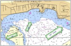
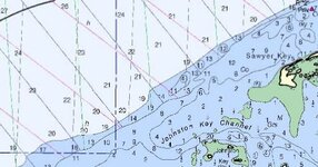
Here is an example of a standard NOAA navigation chart. The blue color changes at the 18 foot mark. I know the draft of the old galleon's was around 18 feet. Is this how this contour color change came about, or is there a different reason?


") ---- Ivan
---- Ivan
