pcolaboy
Hero Member
Ok the subject sounded a bit weird but it really kinda falls in line with some discussion that was going on regarding the Atocha Coordinates where the guy wondered if it were visible on Satellite imaging sites.
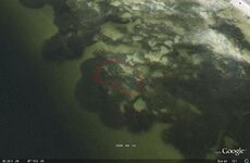
Well I thought some of you may be interested in seeing a genuine 18th century Spanish wreck site using Virtual Earth. The wreck is of the Nuestra Señora del Rosario y Sanitago Apostol that sank during a hurricane in Pensacola Bay in 1705. This vessel was an older frigate that was built in Veracruz thirty years previously. She was moored by 5 anchors during the storm and all gave way sending her smashing into shallows and breaking in two pieces. This wreck site is believed to be only the forward 2/3 of the ship while the stern section has yet to be found. Ok here's a cropped picture of the wreck using Microsoft Virtual Earth in Bird's Eye mode:

This view has South at the top and North at the bottom. You can just see the coastline of Santa Rosa Island in this shot.
Here's the direct link to the site if you want to pan around and what not:
http://maps.live.com/?v=2&sp=Point.p1n5xd7qt1xc_Nuestra Senora de Rosario y Apostol____&encType=1
The exposed portions of the wreck site is essentially a mountain of ballast rock. The site was explored by the University of West Florida Underwater Archaeology group and when they were done, they backfilled the site, covered the very well preserved hull remains with a tarp, and backfilled again with more sand and ballast stone. The ballast stone mound begins at around 9 feet and continues down a fairly steep drop off to about 35 feet of water. The site is much larger than the photograph reveals.
I guess my point in posting this is that a good knowledge of what the normal bottom terrain in your waters are is essential in spotting something that shouldnt be there. Since there are no natural rock formations in our bay waters, a big pile of dark objects is one of two things: a turtlegrass bed or a manmade object(s).
Pcola
Well I thought some of you may be interested in seeing a genuine 18th century Spanish wreck site using Virtual Earth. The wreck is of the Nuestra Señora del Rosario y Sanitago Apostol that sank during a hurricane in Pensacola Bay in 1705. This vessel was an older frigate that was built in Veracruz thirty years previously. She was moored by 5 anchors during the storm and all gave way sending her smashing into shallows and breaking in two pieces. This wreck site is believed to be only the forward 2/3 of the ship while the stern section has yet to be found. Ok here's a cropped picture of the wreck using Microsoft Virtual Earth in Bird's Eye mode:
This view has South at the top and North at the bottom. You can just see the coastline of Santa Rosa Island in this shot.
Here's the direct link to the site if you want to pan around and what not:
http://maps.live.com/?v=2&sp=Point.p1n5xd7qt1xc_Nuestra Senora de Rosario y Apostol____&encType=1
The exposed portions of the wreck site is essentially a mountain of ballast rock. The site was explored by the University of West Florida Underwater Archaeology group and when they were done, they backfilled the site, covered the very well preserved hull remains with a tarp, and backfilled again with more sand and ballast stone. The ballast stone mound begins at around 9 feet and continues down a fairly steep drop off to about 35 feet of water. The site is much larger than the photograph reveals.
I guess my point in posting this is that a good knowledge of what the normal bottom terrain in your waters are is essential in spotting something that shouldnt be there. Since there are no natural rock formations in our bay waters, a big pile of dark objects is one of two things: a turtlegrass bed or a manmade object(s).
Pcola


 Still is,and packed with so many ships in a hurricane..