pcolaboy
Hero Member
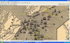
There are a few sites of interest that I'm looking for using mid-19th century charts. These charts were developed by the old US Coast Survey Office using the "Trigonometrical Survey" method. The charts do specify the major lat/lon lines down to minutes.
For a goof, I set about to try and calculate specific coordinates of these sites using a ruler and a calculator. As an example, lets say that a wreck is marked on this old chart that lies a certain distance north of the marked Latitude line of 15' and a certain distance west of the marked longitude line of 5'.
Here are some steps I took to try and get a fairly accurate set of coordinates - this is going to get confusing so maybe sketch out on paper what I'm talking about.
1. Printed the chart on a large plotter to preserve the original aspect ratio of height and width.
2. Got a large transparent ruler with millimeter markings
ASSUMPTIONS
1. The marked lat/lon lines on the old chart are reasonably accurate
2. The location of the wreck was marked with reasonable accuracy in relation to the lat/lon lines.
CALCULATIONS
1. Measured the distance in mm between two adjacent lattitude marks (let's call this Y) Y=103mm
2. Measured the distance in mm between two adjacent longitude marks (let's calll this X) X=95mm
3. Measured the distance in mm from the wreck mark to the nearest lattitude mark to the south (lets call this A) A=13mm
4. Measured the distance in mm from the wreck mark to the nearest longitude mark to the east (lets call this B) B=73mm
5. Calculated the proportion of A and Y (13/103) to arrive at .126 or 12.6% of 1 minute lattitude [7.57" (seconds)]
6. Calculated the proportion of B and X (73/95) to arrive at .768 or 76.8% of 1 minute longitude [46.08" (seconds)]
7. Took the nearest lattitude line (15') and added the calculated seconds to arrive at 15' 7.57"
8. Took the nearest longitude line (5') and added the calculated seconds to arrive at 5' 46.08"
Plugged the numbers into Google Earth and was pretty happy to see that the site was in the area I thought it would be. Then I opened up my collection of interesting sites I found on VirtualEarth's hi-res photos and was thrilled to see the object below in the EXACT location as my calculated coordinates.

I should point out that this is the only bottom feature visible within a mile or so - the surrounding area is sand only. I will try to get out later in the week to ground-truth the site. According to the scale on VirtualEarth, the dark round area is about 6 meters in width. Ballast pile maybe?
Has anyone used similar techniques on old charts to locate wrecks with any luck?
Pcola
For a goof, I set about to try and calculate specific coordinates of these sites using a ruler and a calculator. As an example, lets say that a wreck is marked on this old chart that lies a certain distance north of the marked Latitude line of 15' and a certain distance west of the marked longitude line of 5'.
Here are some steps I took to try and get a fairly accurate set of coordinates - this is going to get confusing so maybe sketch out on paper what I'm talking about.
1. Printed the chart on a large plotter to preserve the original aspect ratio of height and width.
2. Got a large transparent ruler with millimeter markings
ASSUMPTIONS
1. The marked lat/lon lines on the old chart are reasonably accurate
2. The location of the wreck was marked with reasonable accuracy in relation to the lat/lon lines.
CALCULATIONS
1. Measured the distance in mm between two adjacent lattitude marks (let's call this Y) Y=103mm
2. Measured the distance in mm between two adjacent longitude marks (let's calll this X) X=95mm
3. Measured the distance in mm from the wreck mark to the nearest lattitude mark to the south (lets call this A) A=13mm
4. Measured the distance in mm from the wreck mark to the nearest longitude mark to the east (lets call this B) B=73mm
5. Calculated the proportion of A and Y (13/103) to arrive at .126 or 12.6% of 1 minute lattitude [7.57" (seconds)]
6. Calculated the proportion of B and X (73/95) to arrive at .768 or 76.8% of 1 minute longitude [46.08" (seconds)]
7. Took the nearest lattitude line (15') and added the calculated seconds to arrive at 15' 7.57"
8. Took the nearest longitude line (5') and added the calculated seconds to arrive at 5' 46.08"
Plugged the numbers into Google Earth and was pretty happy to see that the site was in the area I thought it would be. Then I opened up my collection of interesting sites I found on VirtualEarth's hi-res photos and was thrilled to see the object below in the EXACT location as my calculated coordinates.
I should point out that this is the only bottom feature visible within a mile or so - the surrounding area is sand only. I will try to get out later in the week to ground-truth the site. According to the scale on VirtualEarth, the dark round area is about 6 meters in width. Ballast pile maybe?
Has anyone used similar techniques on old charts to locate wrecks with any luck?
Pcola


 I swear between my boat breaking down and my wife wanting a break from our two little kids, I mind as well rent some space down at the library
  Not that I have anything against researchers...but I'm more of an active participant whenever the three W's cooperate (Wife, Weather, Wallet).