I was out with my sluice and found this strange rock in southern california

pistol perfect

Full Member
Feb 7, 2008
195
7
southern california
Detector(s) used
fisher gold bug pro
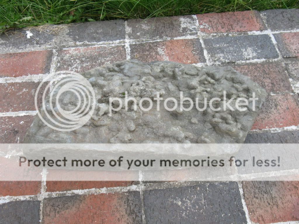
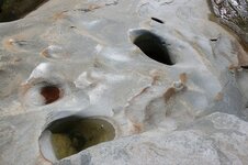
I am not sure if this was used long ago or not but I found this in the southern california mountains today when I was out with my sluice box. its about 25 pounds and looks like it has a carved out hole??? may be natural or may be a old tool??? I gave up detecting and now I sluice and pan!!! VERY HARD WORK!!!! ANY THOUGHTS? I left it in the mountains but may return to get it if its a old tool??? I had about 80 pounds of gear on me and I was 2 miles from my car so I did not want to carry it all the way back.
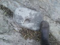
 

Attachments

  • securedownload.jpg
    securedownload.jpg
    137.3 KB · Views: 2,649
  • securedownload.jpg
    securedownload.jpg
    137.3 KB · Views: 1,276

russau

Gold Member
May 29, 2005
7,279
6,735
St. Louis, missouri
it looks like a ole rubber boot to me! :) SORRY! but i appears to me it may have been used for grinding corn/seeds or it could be just a rock that got a hole bored into it! my wifes relations (N. California)have bigger rocks in their back yrad that were used to grind seeds/corn and the holes are similar to yours!id bet it was for grinding seeds.
 

placertogo

Sr. Member
Aug 25, 2010
371
350
Maine USA
It does not appear to be perfectly round so I wonder if it might be a "boil hole" from a piece of bedrock which later broke away and washed downstream.
 

placertogo

Sr. Member
Aug 25, 2010
371
350
Maine USA
Speaking of strange rocks, here are some pics of one I found here in Maine while prospecting a small stream.
Rock3.jpg

Rock4.jpg
bucket.com/albums/oo115/gutfinski/Rock1.jpg[/IMG]
Rock2.jpg
 

EvilJLS

Tenderfoot
Sep 12, 2011
6
0
I looks like an indian grinding stone to me. There are many of them scattered throughout California where Native Americans lived. It could be a boil hole where pebbles ground it out in the stream. The small size of the overall stone makes it more likely it was a Native American tool. The bottom rock looks like a cast or mold of worm holes or just the bottom of a lake or sea. When the silt and dirt is deposited in the lake, stream, or sea it fills in holes and the irregular bottom and forms a flat layer. Later after it's compressed into a rock it retains that shape and can split apart and you end up with whats in the picture. It's a quite common occurance. In many cases if it weren't for rocks like that we wouldn't have a clue what was on the bottom of prehistoric bodies of water as the creatures were soft bodied and dont leave fossils.
 

Maitland

Full Member
Mar 15, 2010
172
159
Black Hills, South Dakota
Detector(s) used
White's Silver Eagle, Fisher Gold Bug 2
Primary Interest:
Prospecting
Well, I'm not sure but it could be a type of rock called 'omar'. I have found omar quite often in the midwest, usually in areas subject to glacial till. I'm not exactly sure how it's formed or what makes it's "dimples" (somebody told me once but I forget). I know I've met many people who swore up, down, and all around that they've got some special type of native-American artifact and it's impossible to convince them otherwise... in fact a friend of mine's father used to have one (heck, probably still does) that he "guessed" the natives made by rubbing sticks inbetween their hands on top of the rock (I think threir hands would've been worn down to bare bones by the time an indentation in the rock got started!) Oh well, it makes for a good story, we always laughed at him for his theory! They are cool rocks though, but there's a difference between them and artifacts. Like I said, I'm not saying that's what you found, but there's a chance it could be.
 

johnedoe

Bronze Member
Jan 15, 2012
1,489
2,239
Oregon Coast
Detector(s) used
White's V3i, White's MXT, and White's Eagle Spectrum
Cleangold sluice & prospectors pan, EZ-Gold Pan, and custom cleanup sluice.
Primary Interest:
Other
Some kind of natural cement formation....... go over it with a good metal detector....... you never know, might be a surprise embedded in it.
 

63bkpkr

Silver Member
Aug 9, 2007
4,069
4,618
Southern California
Detector(s) used
XLT, GMT, 6000D Coinmaster
Primary Interest:
All Treasure Hunting
There are a lot of strange rocks in SoCal. Some of them even talk and appear to be human......had to throw that in.............63bkpkr

I've seen boil holes both larger and smaller and then I've seen some acorn grinding holes and they looked similar though the grinding holes edges were sloped in a bit more
 

kuger

Gold Member
Nov 6, 2007
9,721
2,794
Detector(s) used
,M.X.T.& Tesoro Tejon
Primary Interest:
All Treasure Hunting
its def. not a grinding rock(also Cali Indians didnt have corn)its a natural boil out.......I have a stream that has hundreds of em,from that small to 7' deep
 

TerryC

Gold Member
Jun 26, 2008
7,735
10,996
Yarnell, AZ
Detector(s) used
Ace 250 (2), Ace 300, Gold Bug 2, Tesoro Cortes, Garrett Sea Hunter, Whites TDI SL SE, Fisher Impulse 8, Minelab Monster 1000, Minelab CTX3030, Falcon MD20, Garrett Pro-pointer, Calvin Bunker digger.
Primary Interest:
Metal Detecting
I have seen 44 grinding holes at the Clark Flat (Collierville) power plant. yours is not indian made. There are also several natural holes (like yours) on the North Fork of the Stanislause. One is 4 feet in diameter and 5 feet deep! Just a note... if you believe it is indian made... leave it lie! Too much to lose if "the man" catches ya! TTC
 

TerryC

Gold Member
Jun 26, 2008
7,735
10,996
Yarnell, AZ
Detector(s) used
Ace 250 (2), Ace 300, Gold Bug 2, Tesoro Cortes, Garrett Sea Hunter, Whites TDI SL SE, Fisher Impulse 8, Minelab Monster 1000, Minelab CTX3030, Falcon MD20, Garrett Pro-pointer, Calvin Bunker digger.
Primary Interest:
Metal Detecting
Here are some pics of the holes on the North Fork Stanislaus. Made by the hand of God. These are at the end of Candy rock Ln (Hunter Dam Rd) Hathaway Pines, CA. Easy access unless snow covered. TTC
 

Attachments

  • holes.jpg
    holes.jpg
    84.1 KB · Views: 436
  • holes1.jpg
    holes1.jpg
    92.7 KB · Views: 529
  • holes2.jpg
    holes2.jpg
    78.9 KB · Views: 511
  • holes4.jpg
    holes4.jpg
    60.3 KB · Views: 605

CharlesP

Sr. Member
May 18, 2012
258
53
Merced/Mariposa
Detector(s) used
Still searching for the right one
Primary Interest:
Prospecting
Is this area public? I live in Merced and like to learn about different options. Thxs for the pics
 

SCBUZZ

Jr. Member
Mar 27, 2010
58
0
Primary Interest:
Prospecting

TerryC

Gold Member
Jun 26, 2008
7,735
10,996
Yarnell, AZ
Detector(s) used
Ace 250 (2), Ace 300, Gold Bug 2, Tesoro Cortes, Garrett Sea Hunter, Whites TDI SL SE, Fisher Impulse 8, Minelab Monster 1000, Minelab CTX3030, Falcon MD20, Garrett Pro-pointer, Calvin Bunker digger.
Primary Interest:
Metal Detecting
Is this area public? I live in Merced and like to learn about different options. Thxs for the pics
Charles, If you are refering to my pics, yes, public. Also public at the Collierville power plants (at least 44 holes). I know of at least 2 other spots "up off the river" but they are on private property. To get to the collierville site, take Camp Nine Road off of Perrott's Ferry Road, near Murphys. Federal regs will NOT allow disturbing the site. Cross the spillway, head torwards the river (on the path) and watch for the site under trees and shrubs on the right... Not down to the river, but high. Enjoy. TTC
 

CharlesP

Sr. Member
May 18, 2012
258
53
Merced/Mariposa
Detector(s) used
Still searching for the right one
Primary Interest:
Prospecting
Thanks for the info. Sorry I didn't get back sooner. Damn gold fever. Thanks
again
 

TerryC

Gold Member
Jun 26, 2008
7,735
10,996
Yarnell, AZ
Detector(s) used
Ace 250 (2), Ace 300, Gold Bug 2, Tesoro Cortes, Garrett Sea Hunter, Whites TDI SL SE, Fisher Impulse 8, Minelab Monster 1000, Minelab CTX3030, Falcon MD20, Garrett Pro-pointer, Calvin Bunker digger.
Primary Interest:
Metal Detecting
Thanks for the info. Sorry I didn't get back sooner. Damn gold fever. Thanks
again
Charlie, Just to know, if you walk down the path and go far enough to see river (Collierville site, you walked too far). Except for two or three holes in the open, all the others are somewhat hidden from view. At the Candy Rock Rd. site, go to end of road. Go left from parking lot. Northeast direction. There is a bit of downward steps to negotiate. Be careful with small children and elderly. But the effort is well worth it. You may have to AVERT your eyes from possible public nudity! But rare. (rare for me to avert my eyes, I mean!) TTC
 

Top Member Reactions

Users who are viewing this thread

Latest Discussions

Top