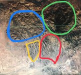
I'm planning a trip for later this year, or next if this year doesn't work out.. and I've got a question about who owns what, as I don't want to trespass on anybody's land, or get into any kind of legal trouble for being where I shouldn't be.. I've searched for maps that would answer my questions to no avail, so I figured I'd ask you all..
If I'm not mistaken the Superstition major I believe I've heard it called, circled in blue, is federally owned, and is restricted to everything except hikers, and horses..
Is the area in the green circle the same as the area in the blue ?
Is the area in the red circle state owned maybe ? I believe it's open to vehicler traffic as I saw trails/tire tracks on google earth ? Except for the bottom left corner where I saw a few houses.
Now the area in the yellow, I would think that the ranch at the end of Gold Rush Rd owns a fair piece of it, but how much ?
Thanks for any info you can give me.


