I figure I'll probably never make it out to the superstitions, and even if I do i'm to crippled up to do any climbing up hills.. So I might as well throw this out there and see what you all think..
I never really believed much in the stone maps, at least not telling the way to the Dutchman’s mine anyway.. But after looking at them I think they would more than likely point the way to a Peralta cache if anything..
If the stone maps are real, and that's a big IF, then this is where I think they point to..
We've all seen this image a bunch of times..
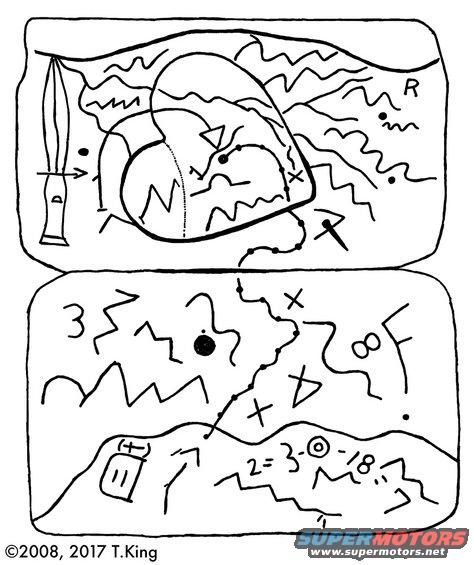
Well here is my interpretation of it..
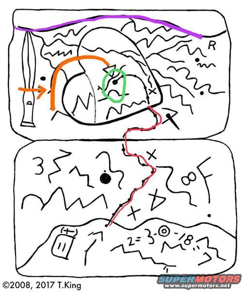
1.. Everyone thinks that the purple line represents the Salt River, but I think it represents the southern edge of the valley to the east of Gold Cannon..
2.. The red is the trail coming in from down around Queen Valley.
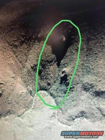
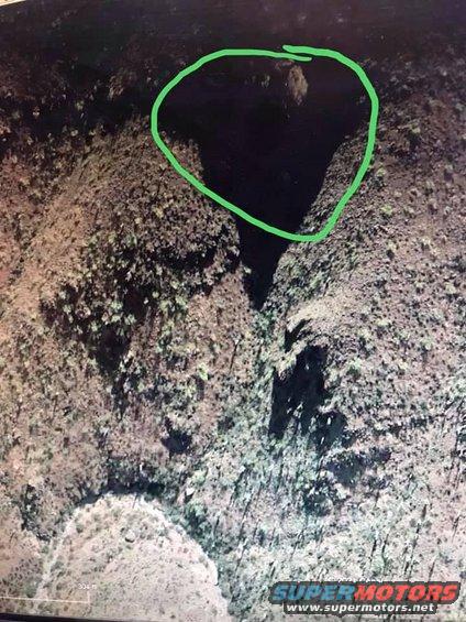
3.. The green is the cache site over the arch.
4.. The orange is the short cut as it would seem, knife meaning “cut”
5.. The squiggly lines are just that, generic lines that represent random mountains..
6.. I don't think the numbers are really that important as people think, If anything I think they might be for the final spot once your in the right area..
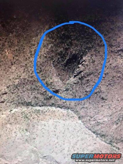
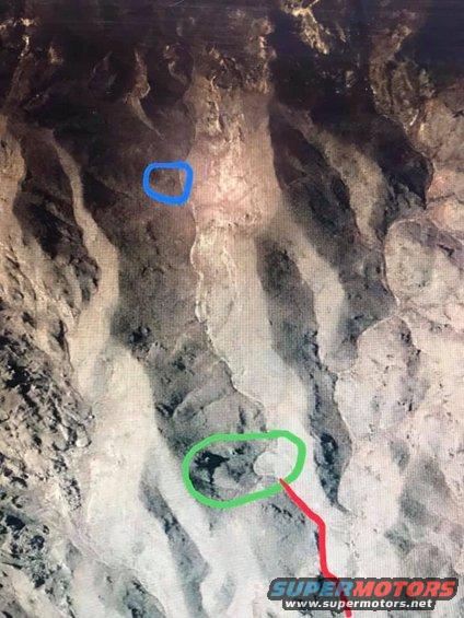
I think the recessed heart in the stone represents just that, a recessed or sunken heart.. Well the shape of a heart anyway..
I also feel that the arch isn't an arch in the way most people think.. That is to say it isn't a vertical rock formation that one could pass through, I feel it is a arch shape on the ground..
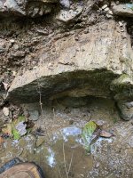
Something that has always bothered me about some of the theories I've seen on here is that the images from google earth could not have been seen from the air in those days.. However, the ones I've posted could be seen from the hill side across from them very easy..
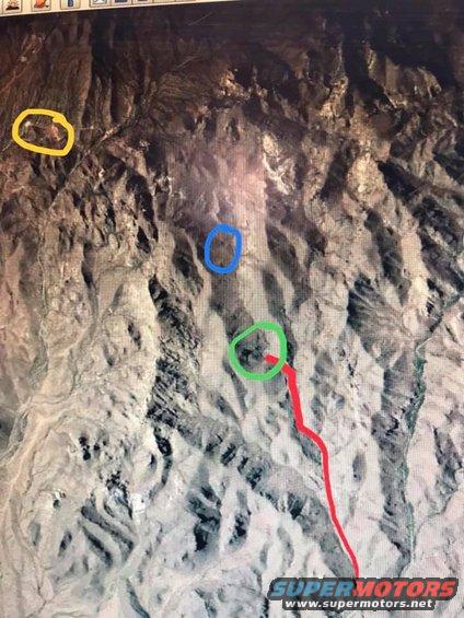
Over the arch and slightly to the right is where I believe the cache to be.
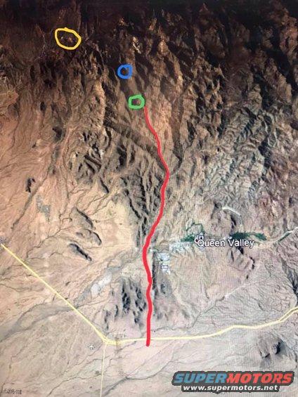
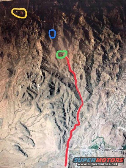
I have color coded the next few images, to help you get an ideal of where I'm talking about..
1.. Yellow for the ranch at the end of East Gold Rush Road, I can't remember it's name
2.. Blue is the sunken heart
3.. Green is the arch, and over it is where I believe the cache to be
4.. And red is of coarse the trail.
Like I said before, I don't really believe in the stone maps so I really doubt anything is there.. But if one of you was to check it out and actually find something, be a pal and slip me a couple million.. lol
I never really believed much in the stone maps, at least not telling the way to the Dutchman’s mine anyway.. But after looking at them I think they would more than likely point the way to a Peralta cache if anything..
If the stone maps are real, and that's a big IF, then this is where I think they point to..
We've all seen this image a bunch of times..
Well here is my interpretation of it..
1.. Everyone thinks that the purple line represents the Salt River, but I think it represents the southern edge of the valley to the east of Gold Cannon..
2.. The red is the trail coming in from down around Queen Valley.
3.. The green is the cache site over the arch.
4.. The orange is the short cut as it would seem, knife meaning “cut”
5.. The squiggly lines are just that, generic lines that represent random mountains..
6.. I don't think the numbers are really that important as people think, If anything I think they might be for the final spot once your in the right area..
I think the recessed heart in the stone represents just that, a recessed or sunken heart.. Well the shape of a heart anyway..
I also feel that the arch isn't an arch in the way most people think.. That is to say it isn't a vertical rock formation that one could pass through, I feel it is a arch shape on the ground..
Something that has always bothered me about some of the theories I've seen on here is that the images from google earth could not have been seen from the air in those days.. However, the ones I've posted could be seen from the hill side across from them very easy..
Over the arch and slightly to the right is where I believe the cache to be.
I have color coded the next few images, to help you get an ideal of where I'm talking about..
1.. Yellow for the ranch at the end of East Gold Rush Road, I can't remember it's name
2.. Blue is the sunken heart
3.. Green is the arch, and over it is where I believe the cache to be
4.. And red is of coarse the trail.
Like I said before, I don't really believe in the stone maps so I really doubt anything is there.. But if one of you was to check it out and actually find something, be a pal and slip me a couple million.. lol
Amazon Forum Fav 👍


Last edited: