Misc data and adventures of a Tayopa treasure hunter

: Michael-Robert.

Bronze Member
Feb 2, 2013
1,426
1,991
Sovereign America
Detector(s) used
Many
Primary Interest:
All Treasure Hunting
And what are the actual names of Timpagos river and Santa Ana river?

Hello markmar,

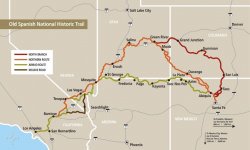
At the time of 1814, I was able to locate two Santa Anna Rivers. One near "The Alamo", Tx. And One in Utah now called the Green River. In those days they use to call and get mixed up the rivers in these areas. I have many maps which show Santa Anna rivers a plenty.

As for Timpagos, that is the river around Mount Timpanogos, often referred to as Timp, is the second highest mountain in Utah's Wasatch Range. Timpanogos rises to an elevation of 11,752 ft (3,582 m) above sea level in the Uinta-Wasatch-Cache National Forest.
OSTA-Map-KNsmall.jpg :coffee2:
 

Last edited:

markmar

Silver Member
Oct 17, 2012
4,117
6,259
Primary Interest:
All Treasure Hunting
Hello markmar,

At the time of 1814, I was able to locate two Santa Anna Rivers. One near "The Alamo", Tx. And One in Utah now called the Green River. In these days they use to call and get mixed up the rivers in these areas. I have many maps witch show Santa Anna rivers a plenty.

As for Timpagos, that is the river around Mount Timpanogos, often referred to as Timp, is the second highest mountain in Utah's Wasatch Range. Timpanogos rises to an elevation of 11,752 ft (3,582 m) above sea level in the Uinta-Wasatch-Cache National Forest.

View attachment 1703570 :coffee2:

Now we have something to look for.
 

PROSPECTORMIKEL

Silver Member
Mar 31, 2011
2,624
9,424
N/W ARKANSAS
Detector(s) used
FISHER
Primary Interest:
All Treasure Hunting
Howdy Mikel,

I have just finished looking into the legua measurement which kept changing over the centuries, and they did mention the vara Castellana de Burgos, so it is one and the same. Burgos is the capital of the kingdom of Castile. One of my ancestors is in a tomb in the cathedral of Burgos. Pedro de Velasco second count of Haro, and sixth constable of Castile. Embrym's posts got me looking into the Josephine, and to me it seems to be neither by Hoyt Peak, or the Henry Mountains. :dontknow:

Homar


Thank you Homar, and embrym as well, since he got you studying this!

I was getting ready to start looking for an answer to the question on my own, when I read what you had written.

I was surprised that anyone would have the answer so quickly.

That is pretty much, the best answer that anyone could have known.

Now I feel a bit embarrassed, that I said that I would regret asking...,

I am glad that I am surrounded by such intelligent friends!!
 

coazon de oro

Bronze Member
May 7, 2010
1,623
3,858
texas
Primary Interest:
All Treasure Hunting
Homar,

What have you come up with for its locations?? It has been mentioned many times for many locations. Many maps.


Howdy embrym,

The Spanish directions clearly state 12 "leguas" West of the Timpanogos River. Hoyt Peak is to the East, and the Henry Mountains are no where near. In my search I found that the Timpanogos River was renamed as the Provo River. I also found that at that time, the "legua" measured 5,472 meters. Since that river doesn't run straight North to South, I took several measurements to begin my search.
I don't know about Captain Jose Joaquin Garcia, but most of the explorers, ship captains, and mineralogists were either Basque, or has a Basque in their crew helping them. The Basque were the elite of the elite, the first to sail around the world, and most of the Spanish ships sailing at that time were made in Basque shipyards. In other words they could measure longitude on water, or land with the sextant. They did not have to walk for a day to get a measurement.
From 5 different measurements, most put me just inside a valley, while some put me just inside some mountains close to that valley. The measurements just inside the valley are the only ones close to the mouth of another river, which has to be Garcia's Santa Anna River. It seems to me that Garcia took the measurement from the Timpanogos River, at the junction of hwy 189 and 92. They had maps with their trails, and trails later became our roads.
From there 12 "leguas" West puts you in what would be "Hiebra" Valley, closest town is Stockton. In that valley below Stockton, you can find where a river, and many creeks ended up in a very small lake. It is hard to tell the exact point where the mouth of that river used to be, but I picked a spot near the center of the South part of that small lake. I can later give you the coordinates for it.
From the mouth of that river, you go 2 "leguas" to the South East, then 1 "legua" South "por tierra" (by land) meaning not through the mountains, but just inside the valley. From there you will take a canyon that enters the valley from the East. The town of Mercur is in that canyon. You follow the canyon to a round peak bare of trees, and from that bare round peak you measure l600 varas North East to the mine.
I can't make out all of what is high lighted in the directions to translate them properly. There is a bare round peak in there, but there was also a lot of strip mining done, so maybe some other bare round peak got leveled?

Homar
 

: Michael-Robert.

Bronze Member
Feb 2, 2013
1,426
1,991
Sovereign America
Detector(s) used
Many
Primary Interest:
All Treasure Hunting
Howdy embrym,

The Spanish directions clearly state 12 "leguas" West of the Timpanogos River. Hoyt Peak is to the East, and the Henry Mountains are no where near. In my search I found that the Timpanogos River was renamed as the Provo River. I also found that at that time, the "legua" measured 5,472 meters. Since that river doesn't run straight North to South, I took several measurements to begin my search.
I don't know about Captain Jose Joaquin Garcia, but most of the explorers, ship captains, and mineralogists were either Basque, or has a Basque in their crew helping them. The Basque were the elite of the elite, the first to sail around the world, and most of the Spanish ships sailing at that time were made in Basque shipyards. In other words they could measure longitude on water, or land with the sextant. They did not have to walk for a day to get a measurement.
From 5 different measurements, most put me just inside a valley, while some put me just inside some mountains close to that valley. The measurements just inside the valley are the only ones close to the mouth of another river, which has to be Garcia's Santa Anna River. It seems to me that Garcia took the measurement from the Timpanogos River, at the junction of hwy 189 and 92. They had maps with their trails, and trails later became our roads.
From there 12 "leguas" West puts you in what would be "Hiebra" Valley, closest town is Stockton. In that valley below Stockton, you can find where a river, and many creeks ended up in a very small lake. It is hard to tell the exact point where the mouth of that river used to be, but I picked a spot near the center of the South part of that small lake. I can later give you the coordinates for it.
From the mouth of that river, you go 2 "leguas" to the South East, then 1 "legua" South "por tierra" (by land) meaning not through the mountains, but just inside the valley. From there you will take a canyon that enters the valley from the East. The town of Mercur is in that canyon. You follow the canyon to a round peak bare of trees, and from that bare round peak you measure l600 varas North East to the mine.
I can't make out all of what is high lighted in the directions to translate them properly. There is a bare round peak in there, but there was also a lot of strip mining done, so maybe some other bare round peak got leveled?

Homar

Homar,

Wow, I've been working this for a while(15+ yrs) and havent come close to what you have found in that direction. I appreciate your research. Its always good to have fresh eyes look at something.... Garcia was a "land soldier" as far as I know. No sea legs for him. Maybe you are right.

I will research your hypothesis and get back with you. Must do my due diligence now.

Thank you Amigo.
 

Last edited:

PROSPECTORMIKEL

Silver Member
Mar 31, 2011
2,624
9,424
N/W ARKANSAS
Detector(s) used
FISHER
Primary Interest:
All Treasure Hunting
Howdy embrym,

The Spanish directions clearly state 12 "leguas" West of the Timpanogos River. Hoyt Peak is to the East, and the Henry Mountains are no where near. In my search I found that the Timpanogos River was renamed as the Provo River. I also found that at that time, the "legua" measured 5,472 meters. Since that river doesn't run straight North to South, I took several measurements to begin my search.
I don't know about Captain Jose Joaquin Garcia, but most of the explorers, ship captains, and mineralogists were either Basque, or has a Basque in their crew helping them. The Basque were the elite of the elite, the first to sail around the world, and most of the Spanish ships sailing at that time were made in Basque shipyards. In other words they could measure longitude on water, or land with the sextant. They did not have to walk for a day to get a measurement.
From 5 different measurements, most put me just inside a valley, while some put me just inside some mountains close to that valley. The measurements just inside the valley are the only ones close to the mouth of another river, which has to be Garcia's Santa Anna River. It seems to me that Garcia took the measurement from the Timpanogos River, at the junction of hwy 189 and 92. They had maps with their trails, and trails later became our roads.
From there 12 "leguas" West puts you in what would be "Hiebra" Valley, closest town is Stockton. In that valley below Stockton, you can find where a river, and many creeks ended up in a very small lake. It is hard to tell the exact point where the mouth of that river used to be, but I picked a spot near the center of the South part of that small lake. I can later give you the coordinates for it.
From the mouth of that river, you go 2 "leguas" to the South East, then 1 "legua" South "por tierra" (by land) meaning not through the mountains, but just inside the valley. From there you will take a canyon that enters the valley from the East. The town of Mercur is in that canyon. You follow the canyon to a round peak bare of trees, and from that bare round peak you measure l600 varas North East to the mine.
I can't make out all of what is high lighted in the directions to translate them properly. There is a bare round peak in there, but there was also a lot of strip mining done, so maybe some other bare round peak got leveled?

Homar


That’s what I meant by intelligent friends!

Wow!
#/;0{>~
 

Last edited:

: Michael-Robert.

Bronze Member
Feb 2, 2013
1,426
1,991
Sovereign America
Detector(s) used
Many
Primary Interest:
All Treasure Hunting
Homar,

A quick Google earth search shows that Mercur is a historical hard rock mining ghost town in Tooele County, Utah, USA. In 1891, it became the site of the first successful use of the cyanide process of gold extraction in the United States, the dominant metallurgy today. Its elevation from sea level is approximately 2,042 m.

And Flat Top Mountain just to the North.
 

Real of Tayopa

Bronze Member
Sep 4, 2016
1,942
9,101
Mexico
Primary Interest:
All Treasure Hunting
EM I am trying to find the way to accept you as a friend, nothing works. I am trying for AU also. Please remember I am not ignoring you.
 

Real of Tayopa

Bronze Member
Sep 4, 2016
1,942
9,101
Mexico
Primary Interest:
All Treasure Hunting
EM the earlyMercury mines mines were strictly a royal thing, by controlling the Mercury he controlled the relative production of Au/Ag. Salt was used at first.
 

markmar

Silver Member
Oct 17, 2012
4,117
6,259
Primary Interest:
All Treasure Hunting
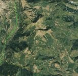
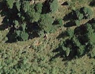
Well, Embrym, I believe I have found the Josephine de Martinique mine spot, and fortunately is few hundred yards out of the green region.
I will send you the coordinates if you will PM your email.

JdeM region.jpg JdeM.jpg
 

PROSPECTORMIKEL

Silver Member
Mar 31, 2011
2,624
9,424
N/W ARKANSAS
Detector(s) used
FISHER
Primary Interest:
All Treasure Hunting
EM the earlyMercury mines mines were strictly a royal thing, by controlling the Mercury he controlled the relative production of Au/Ag. Salt was used at first.


Hi, Don Jose.
I noticed, a week or so ago, while reading the Spanish mining laws, that the Crown had a very powerful hold on the mercury industry...
all mercury was, by Royal decree, to be sold at cost, to the Spanish mines that used mercury.

I didn’t see anything about the price, for the mercury that was used by the Royal refineries.

Just connecting the dots, I would hazard a guess, that it was considered an expense for the Royal authorities to use.

Even when the mine operators used it, they had to document shipments of the reduced ores, as to the usage and present that document before the refining began. Failure to do so would result in large fines and/or prison...

In second offenses, the mine owner could loose all of his mines and even be removed from the mining district, exiled and sentenced to three years, at oar In the Guadal canal (In Spain).

No matter how well refined, the precious metals had no monetary value, until it was refined by the Royal authorities, and stamped with the weight, the purity and the Royal stamp and was recorded.

The power of the Crown, over mining in the New Spain, was no less than it was within the borders of Spain.

The most minute details told the story of every coin and ingot.

€|;0{>~
 

Real of Tayopa

Bronze Member
Sep 4, 2016
1,942
9,101
Mexico
Primary Interest:
All Treasure Hunting
there was plenty of contraband Gold How do you suppose they accumulated so much on Caballo mts, and enough to potentially fund a revolution against Spain, The Jesuits were known for having deep pockets.& Silver & Gold contraband Ag deposits and contraband salt production.
 

Last edited:

PROSPECTORMIKEL

Silver Member
Mar 31, 2011
2,624
9,424
N/W ARKANSAS
Detector(s) used
FISHER
Primary Interest:
All Treasure Hunting
I’ll give you that point...
I guess it worked as long as the Crown believed it worked.

Long live the Black Market!!

{)/.0{>~
 

coazon de oro

Bronze Member
May 7, 2010
1,623
3,858
texas
Primary Interest:
All Treasure Hunting
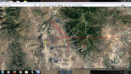
Lake of Mapa de La Paz 1783.JPG

Today it's more of a dry lake, but you can see that "Laguna de Timpanogos" would re-appear there with enough water. The "Sta Ana River" is just below the town of Stockton. It's mouth tends to change a little over the years. I took two measurements where the mouth might have been at that time, and they both put you in front of only one canyon. I was disillusioned to see all the strip mining. Seems like the round top barren peak needed for the proper last measurement may have been leveled. Disregard La Paz County, Az. on top of image, I had been searching for a place that the "Mapa de La Paz of 1783 might fit. That stayed there on top after I found that it was actually in my own search area.

Homar
 

Last edited:

PROSPECTORMIKEL

Silver Member
Mar 31, 2011
2,624
9,424
N/W ARKANSAS
Detector(s) used
FISHER
Primary Interest:
All Treasure Hunting
Homar, you make treasure hunting look easy!

I think that you are concealing a higher IQ than you let us see!

How are you with, jigsaw puzzles, with the colored side down?

#/;0{>~
 

coazon de oro

Bronze Member
May 7, 2010
1,623
3,858
texas
Primary Interest:
All Treasure Hunting
Howdy mi Amigo Mikel, thank you for the kind words, but I have trouble with the puzzle box facing me, with one piece left to complete. I do have a little advantage knowing Spanish, but it is always the grace of God that helps me get things right every now and then.

Homar
 

: Michael-Robert.

Bronze Member
Feb 2, 2013
1,426
1,991
Sovereign America
Detector(s) used
Many
Primary Interest:
All Treasure Hunting
I'm not saying this was me at all :-)

PAGE, Ariz. – Is it a remarkable discovery or a clever hoax?

A hiker in southern Utah has found what appear to be old Spanish coins possibly dating back to the time of the conquistadors and perhaps even earlier, long before the voyages of Columbus.
The big question the National Park Service is trying to answer is: If they’re real, what are they doing in southern Utah?
"This is very exciting," said park service archaeologist Brian Harmon. "I’ve never seen anything like this in my career."
The mystery began last September when a hiker from Colorado made the discovery near the Halls Crossing Marina on Lake Powell. Park officials are keeping the exact location secret because of the possibility there are other undiscovered artifacts in the area. They’ve been keeping the two coins under wraps, too – deliberately not publicizing the find – because they aren’t sure yet what to make of it.
When KSL learned about the coins, though, Harmon confirmed the find and showed off the coins. They’re being kept in Page, Arizona, in the archives of the Glen Canyon National Recreation Area. Museum technician Lisa Riedel carefully unwrapped them while wearing white gloves.
“Well, we’re just trying to not touch them and (not) get oil from hands or whatever else, dirt on them," Riedel explained. “For being in the elements, they look really well-preserved.”


These coins, which appear to be old Spanish coins dating back to the time of the conquistadors and perhaps even earlier, were allegedly found by a hiker near the Halls Crossing Marina on Lake Powell in September 2018. The National Park Service is trying to authenticate the coins and determine how they made it to that location. (Photo: John Hollenhorst, KSL TV)The two small coins – one about the size of a quarter and the other smaller than a dime – definitely give the appearance of being ancient. They don’t appear to be gold; they are slightly greenish in color, suggesting the presence of copper.
"They're very thin," Riedel said. "We're guessing one is probably silver and one is maybe copper."
According to Harmon, the coins were found in a popular tourist area that has at times been underwater in the decades after the Glen Canyon Dam was built in the 1960s. The Colorado hiker, whose identity is being kept confidential, told the park service that he spotted the coins just lying on the ground. He was not using a metal detector; their use is illegal in national recreation areas and other lands administered by the National Park Service.
“There was a lot of trash around," Harmon said. "He thought they (the coins) were maybe medallions from a wine bottle or something. So, modern trash. He picked them up, took them home. When he started looking at them, he’s like, 'Hey, these might actually be something, very old and very important.' He did a bit of research on his own on the internet and figured out that they were old Spanish coins."
The Colorado man’s research brought him to a startling conclusion. He told the park service that he believes the larger one matches coins from the 1660s and the smaller one matches coins from the 1290s, two full centuries before Columbus. With that realization, he decided to turn them over to the park service.
"His behavior was a model of how to respect the history," Harmon said. "You know, he picked these up thinking they were modern trash. It was an honest mistake. And as soon as he realized what he had, he reached out to us."

So what we're doing is reaching out to experts in old Spanish coins to learn, are these authentic? How old are they?—Brian Harmon, Utah State Parks


The park service so far has not confirmed the discoverer’s conclusions.
"So what we're doing," Harmon said, "is reaching out to experts in old Spanish coins to learn, are these authentic? How old are they?"
If they are authentic, that would deepen the mystery: It’s a real puzzler to contemplate how old Spanish coins got to Utah and how they fit into the known history of European exploration. The first well-documented Spanish expedition into the area was in 1776 led by two Spanish priests, Father Atanasio Dominguez and Father Silvestre Velez de Escalante. But the route of the Dominguez-Escalante expedition is well-known; the two priests were never anywhere near Hall’s Crossing where the coins were found.
"I think it's very unlikely that these are associated with Escalante and Dominguez," Harmon said. "One possibility is that there was some Spanish presence in that area that just is undocumented or is very poorly documented. Another possibility is that these coins were traded to a Native American group by the early Spanish explorers and settlers."
It’s also possible, of course, that the whole thing is a modern hoax perpetrated by someone with a yen to distort history. They also could literally be modern trash, some kind of packaging or trinket made to look like Spanish coins.
No matter what, though, for an archaeologist, trash doesn’t get much better than this.
"Spanish coins, Spanish artifacts of this age are extremely rare in the Americas," Harmon said, "so this is really exciting to see this."
The discoverer has chosen to remain anonymous and out of the public eye. He declined a request for an interview.

https://www.ksl.com/article/4653589...cZuS9FAze1cq6u8WZEQEwjII4rjKrOpIo_nnc1APhj6Dw
 

Last edited:

Mackaydon

Gold Member
Oct 26, 2004
24,095
22,873
N. San Diego Pic of my 2 best 'finds'; son & g/son
🏆 Honorable Mentions:
2
Detector(s) used
Minelab Explorer
Primary Interest:
Shipwrecks
Embrym,
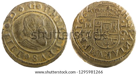
The coins you referenced look legit to me. If authentic, the coin on the right (in that article) was minted in Madrid during the reign of Felipe IV (1621-1665). The denomination is 16 maravedis and (in better days) looked similar to this:
stock-photo-ancient-spanish-copper-coin-of-king-felipe-iv-coined-in-madrid-maravedis-1295981266.jpg

Don........
 

: Michael-Robert.

Bronze Member
Feb 2, 2013
1,426
1,991
Sovereign America
Detector(s) used
Many
Primary Interest:
All Treasure Hunting
Embrym,
The coins you referenced look legit to me. If authentic, the coin on the right (in that article) was minted in Madrid during the reign of Felipe IV (1621-1665). The denomination is 16 maravedis and (in better days) looked similar to this:

Don........

They are legit..No question. The article shows how much people have no clue about the American history.
 

Last edited:

Top Member Reactions

Users who are viewing this thread

Top