Twisted Fork
Hero Member
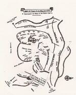
Here ya be.........
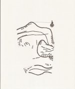
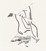
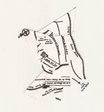
This is the approach sequence as from the first approach. Cut out the pieces, leave the largest 1 single mass of the pieces where it sits. hold the next smallest (sorta hard to tell, part of the Don's stealth) paper piece over the base piece, pinching the paper in the middle as the center of a clock dial. Turn the piece counterclockwise about 17 or or so minutes. In this "area of reference" you will find sign that aligns point to point. Recognize your position here and post it to memory. Go to the third section of paper, Hold and adjust the scope in the same manner and follow through until the end. You can touch the edge of each piece with a little dab of glue if your happy with the assembly. Glue each piece until all have realized their position.
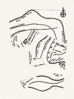
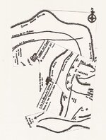
Some of these finished assemblies will lay on a copy of the original map and rotate around to various positions and and of course read back to you, in similar sign the same way the trail assemblies did from the 1st main ground monument leading into the area of Tayopa. Backwards W?
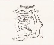
The base image is of course a water bag skin that appears to be full; the intersection of the cross finds the water of life.
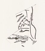
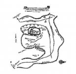
This is the approach sequence as from the first approach. Cut out the pieces, leave the largest 1 single mass of the pieces where it sits. hold the next smallest (sorta hard to tell, part of the Don's stealth) paper piece over the base piece, pinching the paper in the middle as the center of a clock dial. Turn the piece counterclockwise about 17 or or so minutes. In this "area of reference" you will find sign that aligns point to point. Recognize your position here and post it to memory. Go to the third section of paper, Hold and adjust the scope in the same manner and follow through until the end. You can touch the edge of each piece with a little dab of glue if your happy with the assembly. Glue each piece until all have realized their position.
Some of these finished assemblies will lay on a copy of the original map and rotate around to various positions and and of course read back to you, in similar sign the same way the trail assemblies did from the 1st main ground monument leading into the area of Tayopa. Backwards W?
The base image is of course a water bag skin that appears to be full; the intersection of the cross finds the water of life.