GOOGLE Earth, researching old sites

BuffaloBob

Bronze Member
Jan 6, 2005
1,367
262
Rocky Mountains
Detector(s) used
Minelab X-Terra 705 Gold Coil
deteknixXpointer Probe
Minelab Ex-Terra 70
White's Classic II
2014-2015 Colorado Gold Camp Prospector
Primary Interest:
Metal Detecting
Google Earth is my best friend. Love looking at old maps and stories about communities that once thrived and are now lost.

By Lost I mean you can't find in your car. Nothing visible from the road even across flat land. You know something is out there but all landmarks, structures etc are gone. Plowed under, destroyed or built on. Then I discovered Google Earth.

For example we were looking for the actual site of a stage stop in COMANCHE COLORADO. Here's what we found from the air..
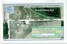
Comanche.jpg
Using mapping software ACME MAPPER 2.0, foundations are clearly visible. Their software allows Topo and Terrain overlays.
Topo shows structures not evident on Google till you look closely.
Mark every possible habitation site.
Take a screen shot which includes GPS data.
Write the name of the place in terms you can research later: History of the area, structures, families, etc. That is so interesting to me.
One townsite is known in local lore only.

Original town flooded out.
Moved to higher ground
Tornado struck so moved again
Fire this time. Still a garage standing but the original sites are unknown.

Looking at historical records, old photographs, my friend Doug brought the local county history book along.
He knew which Creek flooded so the area was roughly known. And plowed and planted fields. No signs of anything.

UNTIL Doug said "isn't that the wooden Windmill in the picture"? Wow.. YES IT WAS.

That was the original town site. Couldn't get the van through the wash. Bridges long lost. Four wheeler could make it OR long hike for some tired old guys. Instead glassed the area with Binoculars. And I shot a picture.

Now having a statrting spot for townsite #1, and #3 we knew the #2 location was somewhere nearby.
Google Earth showed that site planted and no access road other than farm access. Probably nothing there but WE DID IT! Found the bugger, lost for generations. And have the GPS data and pictures. To return if we want to.
That's my story and I'm stickin to it!
BB
 

Hitndahed

Hero Member
Dec 4, 2014
866
874
Deep in the woods in South Central Pa.
Detector(s) used
Fisher CZ7 Pro
Primary Interest:
All Treasure Hunting
I really hope you do know that GE is not the "godsend" that people take it for.
MANY times I have found airbrushed,,,(for the lack of a better word) images there.
Things washed out,,,or even just downright wrong,,,according to people that went and looked at some of them first hand.

GE is a nice tool for sure,, but do please use diligence when using it as your only source of images.
Shadows,,atmospheric conditions and other things do affect the way things look there.
Even the time of day can have an effect on the image you are looking at.

I am not trying to be negative nor trying to get you off any "trail" you may be on.
Just letting you know to use as many sources as you can when it comes to info of this type.

Good luck and HH

Hit
 

BurntBear

Bronze Member
Jul 4, 2014
1,450
1,299
N.E. Tennessee
Detector(s) used
Shovels....lots of shovels!
Primary Interest:
Other
I tend to use a collective of several map sources:

MyLandMatters.org

Google Earth

US-Mining.com
 

OP
OP
B

BuffaloBob

Bronze Member
Jan 6, 2005
1,367
262
Rocky Mountains
Detector(s) used
Minelab X-Terra 705 Gold Coil
deteknixXpointer Probe
Minelab Ex-Terra 70
White's Classic II
2014-2015 Colorado Gold Camp Prospector
Primary Interest:
Metal Detecting
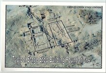
TYPICAL STAGE STOP BUILDINGS - LAYOUT
Typical Stage Stop Layout.jpg
Yes I always keep my map eyes open for this particular foundation plan. Unless terrain or weather caused design to be changed, they all had common features.
Housing on the left side, but look at the top. TOP = TRASH PIT. Who knew? That would be my first place to detect.

Out West wagon wheel tracks are easily seen from above. Most interesting spots to search are usually not close to roads. Access would have to be sorted out. ATV is possible in very rough country. Most country is BLM Grazing land. Getting permission is hard. MANY corporate farms never allow anyone on the property. Period. Legal issues I suppose.. Unless you "know a guy". Usually a neighboring local rancher. Always worth a stop to see if you can access through his property.
You Cowboy guys with horses have it made. I think. NOT a horse guy myself. Trails west went straight ahead through rough country. The middle plains of Colorado are rocks. Some mining there so access roads are close by. Oil & Gas wellheads all over the place! But be careful. Read the signs.. USED to be Missile Sites all over the place. Even if unused you WILL BE MONITORED! Take my word for it. Those guys never sleep. They see you, hear you, have your vehicle license number and know who you are if they need to.

Note: I have detected close to Mexico through Texas, New Mexico and Arizona. It is always a dangerous down there. I suggest carrying some sort of firearm(s). The border is not as secure as we believe. And the dirt is Caliche. Plaster hard with rocks. Which is why not many basements dug down there.
BB
 

boogeyman

Gold Member
Jun 6, 2006
5,016
4,398
Out in the hills near wherendaheckarwe
Detector(s) used
WHITES, MINELAB, Garrett
Primary Interest:
All Treasure Hunting
GE is great, but you need to back it up with good research. Works real good with a handful of the oldest topos you can find. I'm sure many here know the technique of checking old old topos against newer topos. Structure on old map and none on the newer ones is worth looking at as a spot to consider. Add in checking it on GE, and you should be able to find some good starts. Then bring in your history searches at the library & historical societies etc. Research work done, then the fun part, boots on the ground!

If you rely on GE as your only source, you'll be chasing dry holes.

Stated above - Caliche as hard as plaster. You must've hit the easy stuff. Out by Chloride we were digging for a septic tank & broke three teeth off a backhoe.
 

Last edited:
OP
OP
B

BuffaloBob

Bronze Member
Jan 6, 2005
1,367
262
Rocky Mountains
Detector(s) used
Minelab X-Terra 705 Gold Coil
deteknixXpointer Probe
Minelab Ex-Terra 70
White's Classic II
2014-2015 Colorado Gold Camp Prospector
Primary Interest:
Metal Detecting
I tend to use a collective of several map sources:
yLandMatters.org
Google Earth
US-Mining.com

BurntBear thanks! New sources for me that sound right. Actually too many maps around. I find one in a museum online site and spend hours reading it. Once you get the hang of what you're looking at, your imagination takes you over. Older topo maps out west show old farm roads that I like to plan trips to. Many old County Roads have been renumbered or renamed. In the high plains, with no visible landmarks, a guy CAN get lost. My GPS is so useful. Always get me home. So far...

Just now routing a 4:28 hour round trip to visit a few of the remaining 350 agricultural ghost towns in Northern Colorado. For shits and grins and pictures!
Thanks again... Love your part of the country.
BB
 

OP
OP
B

BuffaloBob

Bronze Member
Jan 6, 2005
1,367
262
Rocky Mountains
Detector(s) used
Minelab X-Terra 705 Gold Coil
deteknixXpointer Probe
Minelab Ex-Terra 70
White's Classic II
2014-2015 Colorado Gold Camp Prospector
Primary Interest:
Metal Detecting
GE is great, but you need to back it up with good research. Works real good with a handful of the oldest topos you can find. I'm sure many here know the technique of checking old old topos against newer topos. Structure on old map and none on the newer ones is worth looking at as a spot to consider. Add in checking it on GE, and you should be able to find some good starts. Then bring in your history searches at the library & historical societies etc. Research work done, then the fun part, boots on the ground!

If you rely on GE as your only source, you'll be chasing dry holes.

Stated above - Caliche as hard as plaster. You must've hit the easy stuff. Out by Chloride we were digging for a septic tank & broke three teeth off a backhoe.

How the heck do the underground drug runners ever make a tunnel? And I see the practicality of earth dome homes. I am not a warm weather person. How do you dig? Is dynamite allowed or just a bad idea? A nice RV sure sounds nice. To pack my 15" coil.
BB
 

OP
OP
B

BuffaloBob

Bronze Member
Jan 6, 2005
1,367
262
Rocky Mountains
Detector(s) used
Minelab X-Terra 705 Gold Coil
deteknixXpointer Probe
Minelab Ex-Terra 70
White's Classic II
2014-2015 Colorado Gold Camp Prospector
Primary Interest:
Metal Detecting
Moved to Colo in early 70's. Bought me a bunch of topo fishing/hunting maps. Still got em. My detecting pals bring every map they have. Locate a reliable landmark, compare old and new maps with the actual road signs. Some roads are just gone. Some along fence lines almost got my wife's new Camry. High centered in sand..
One of the guys marks a map to indicate new name or whatever. Fun when you are retired and have no worry about time. Well, business-meeting-time.
BB
 

OP
OP
B

BuffaloBob

Bronze Member
Jan 6, 2005
1,367
262
Rocky Mountains
Detector(s) used
Minelab X-Terra 705 Gold Coil
deteknixXpointer Probe
Minelab Ex-Terra 70
White's Classic II
2014-2015 Colorado Gold Camp Prospector
Primary Interest:
Metal Detecting
Boogey.. boots on the ground. Use to hunt the high country Big game, upland game and camping and fishing. Fell off a steep cliff, nearly drwoned. Used up too many 9 lives. New knee also revises plans. BUT if they ever open forest lands to more ATVs I have many sites to get back to. Including a bugger of a goldcamp area East of Breckenridge Colo. Can't remember some stuff but the important stuff I do!
BB
 

boogeyman

Gold Member
Jun 6, 2006
5,016
4,398
Out in the hills near wherendaheckarwe
Detector(s) used
WHITES, MINELAB, Garrett
Primary Interest:
All Treasure Hunting
How the heck do the underground drug runners ever make a tunnel? And I see the practicality of earth dome homes. I am not a warm weather person. How do you dig? Is dynamite allowed or just a bad idea? A nice RV sure sounds nice. To pack my 15" coil.
BB
Can only use my experiences. Caliche runs in layers in the areas I've been. Once you can get through it then it's back to dirt & rocks. If you've got the certs for dynamite you could, but for the rest of us a jack hammer & a backhoe are your backs best friends. Closest I've been to a earthdome house was a house built out of RR ties. They were stacked & pinned like a log house. The house stayed around 70 - 73 even in 112 degree weather. His floor plan helped distribute air front to back which helped keep the temp good winter & summer. Not to mention it was built in the early 60s and it's still occupied today.
 

boogeyman

Gold Member
Jun 6, 2006
5,016
4,398
Out in the hills near wherendaheckarwe
Detector(s) used
WHITES, MINELAB, Garrett
Primary Interest:
All Treasure Hunting
Boogey.. boots on the ground. Use to hunt the high country Big game, upland game and camping and fishing. Fell off a steep cliff, nearly drwoned. Used up too many 9 lives. New knee also revises plans. BUT if they ever open forest lands to more ATVs I have many sites to get back to. Including a bugger of a goldcamp area East of Breckenridge Colo. Can't remember some stuff but the important stuff I do!
BB
Breckenridge!!!! Man you're in heaven. Used to run around in the Ramparts every time I thought I'd just about seen em all I'd find something else to ooh & ahh at! Not to mention I wish I was about 10 years younger! If you need a good source for research books etc. Stop in at the Tattered Cover bookstore in Denver. They were always great at finding stuff for me.
 

boogeyman

Gold Member
Jun 6, 2006
5,016
4,398
Out in the hills near wherendaheckarwe
Detector(s) used
WHITES, MINELAB, Garrett
Primary Interest:
All Treasure Hunting
Boogey.. boots on the ground. Use to hunt the high country Big game, upland game and camping and fishing. Fell off a steep cliff, nearly drwoned. Used up too many 9 lives. New knee also revises plans. BUT if they ever open forest lands to more ATVs I have many sites to get back to. Including a bugger of a goldcamp area East of Breckenridge Colo. Can't remember some stuff but the important stuff I do!
BB
You're doing better than me! Started forgetting the important stuff, so I started taking notes.......... Now all I gotta figure out is where I put the notes....
 

Charlie P. (NY)

Gold Member
Feb 3, 2006
13,003
17,106
South Central Upstate NY in the foothills of the h
Detector(s) used
Minelab Musketeer Advantage Pro w/8" & 10" DD coils/Fisher F75se(Upgraded to LTD2) w/11" DD, 6.5" concentric & 9.5" NEL Sharpshooter DD coils/Sunray FX-1 Probe & F-Point/Black Widows/Rattler headphone
Primary Interest:
Metal Detecting
Check your county website to see if they have a map site. My state is embracing GIS (Geographic Information System) and my whole county has a satellite imaging that is better than I get off Google Earth (or GE-Pro). And the BIG advantage is tax parcels are marked (to locate owner and age of structures) and also parks and county owned lots are flagged. Free - or at least your share of your tax dollars.
 

Bumbalawski

Full Member
Mar 2, 2015
110
155
Beans Cove Pa.
Primary Interest:
All Treasure Hunting
I have found that using GE in conjunction with GIS works rather well. But nothing beats "boots on the ground". I use these technologies in searching for caves, but also for old building and build site references. When working from an old newspaper article, old deed and land plat surveys also aid in the search. When putting them all together, searching become a whole bunch easier.
 

Dust Eater

Sr. Member
Apr 15, 2015
270
1,126
MASATHVSETS
🥇 Banner finds
2
Detector(s) used
XP Deus
Primary Interest:
Metal Detecting
I've started using the georeferencing feature in ArcGIS and prefer it over Google Earth. That being said, it definitely isn't as user friendly...
 

Last edited:

Top Member Reactions

Users who are viewing this thread

Top