Survey of the MINA VIRGON

OP
OP
sailaway

sailaway

Hero Member
Mar 2, 2014
623
815
Primary Interest:
All Treasure Hunting
The Trick has been solved and the mines found.
The Latan Heart, Sombreo, Virgon de Guadelupe, Cobollo, Priest, Lost Dutchman, Mapa, Coazon, Jes.PNG Cabollo De Sante Fe Vein.PNG Monuments.PNG The real Cabollo de Sante Fe Mine.PNG Golden Heart Capture (2).PNG Skull and Bones.PNG Exact Perfil map view of Mina Virgon de Guadelupe site.PNG Lost Dutchman.PNG Mina Virgon Treasure site must use Tumacacori map to locate from meeting of priest.PNG
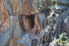
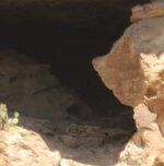
These are all part of the same vein. You can see the black sombrero that is on the hillside in the photo so we know Father Kino was here because he showed the hill with the Black sombrero on his map in the center of the Superstitions. To get into the main mine you walk under a rock carved into an Omega sign. I have actual Photos (they show the same things that Google does but the DOD dumb down what the public gets to see, I have over 5 years invested in research of this area, and have been there several times, and preparing to go back now to these spots for the documentation photos. The whole hillside of the Dutchman has the 8-n-P and is also carved into the Spanish word Espania for Spain Followed by an Arrow pointing at the Gold of the Dutchman Mine. Below the ESPANIA is the name MOLINA, and below that the words Coazone and Mapa cross. Behind the arrow to the south you will find stones carved to form F. KINO that taper from a large F to the smaller o. On the East side in large letters you can see the name PEDRO in Capital letters. This is not some small hill but a very large one, almost a mountain in its own right. Yes I have a picture to prove it and no you can not see it yet, waiting on Congressional protection of The National Trust for Historic Preservation.
 

Last edited:
OP
OP
sailaway

sailaway

Hero Member
Mar 2, 2014
623
815
Primary Interest:
All Treasure Hunting
The Battle of White Hill
Geronimo stated in his Biography the he fought the Mexicans in the Battle of White Hill during the 1800's. When he left the battle site he took Fish Creek Canyon back to his village. Fish Creek is on the north side of this site so White Mountain is the site of this battle between the Apache and the Mexican/Spanish. This was the second time the Mexican / Spanish had been in a skirmish at this spot with the Apache over encroachment of the home of the Thunder God considered sacred by the Apache. The story of Don Garcia Lopez de Cardenas return to Neuva Espaina confirms that this site dates back to Coronado's quest for the Seven Cities of Gold, Cibola. This makes this the First Town in the United States, known as San Geronimo de las Corazones AKA the first site of Tumacácori, or Saint Jerome of the Hearts. The fist town was abandoned while Coronado was away, then the second town was built on the Santa Cruz River after the first place was abandoned because of continued Indian attacks. Miners found gold here and because it was so rich they risked the continual Indian attacks for the gold. I believe I have located the Temple along Rogers Canyon Trail, it is just East of the Heart minus the M carving on the cliff face. There you will find a large rock shaped in the form of the Greek sign Omega standing up, this is the Temple entrance or courtyard. Is this the fabled Church of Santa Fe who's treasures are in the Billions? The Cobollo de Santa Fe is here so why not?
First Tumacacori.jpg
next we have the welcome sign to the city which has a map of the area on it with descriptions of landmark signs
Survey Stone.jpg
All Seeing Eye.PNG Seeing Eye Legend.PNG Thunder God.PNG
Here is the Indian God giving the Breath of Life to the Indian Man, second photo shows the hand, Then you have the son of God praying for mankind (look inside to see).

Rogers Canyon Horse and Heart.png
View of White Mountain from the top of Stairs descending down west side of Iron Mountain. You can see the Monuments make up a large horse with a heart between its legs. On the back of the horse you may notice the face of Montezuma looking skyward.
 

Last edited:
OP
OP
sailaway

sailaway

Hero Member
Mar 2, 2014
623
815
Primary Interest:
All Treasure Hunting
America Unearthed shows to the clues.
Tracking the Templars
Premiere Date: March 01, 2013 - 10:00-11:00PM ET
When Scott Wolter began investigating mysterious artifacts, he started to notice one unique symbol appeared on many of them. The symbol, now known as the "Hooked X", baffled researchers who couldn't make sense of it. As Scott's investigation into the origins of the symbol unfolds, he realizes its use is unique to just two notoriously secret groups–the Knights Templar and their modern day brethren, the Freemasons. Used in secret codes, cryptic ciphers and even the alleged tomb of Jesus himself, the symbol could be the key to understanding two of the biggest mysteries of all time–exactly what the Holy Grail is, and where it's hidden today.

Hunt for the Holy Grail
Premiere Date: March 15, 2013 - 10:00-11:00PM ET
The Holy Grail is one of the most sought after treasures of all time, and one treasure hunter thinks he knows exactly where it is. He invites Scott Wolter along on his quest to find it, and the result is a North American treasure hunt of epic proportions. Legends, a treasure map and the results of ground penetrating technology all point to the Grail being in a single location–a holy well on the property of a rumored Templar Prince. What Scott finds in and around the well will shock even the skeptics in this edge-of-your-seat season finale.
Upcoming Airings:
December 24, 2014 - 06:00-07:00PM ET

The Desert Cross
Premiere Date: February 22, 2013 - 10:00-11:00PM ET
Heading to Tucson, Arizona with his son Grant, Wolter is eager to investigate a mysterious cache of crosses, swords and other relics pulled from the desert in the 1920s. One sword has a date–800 AD–written in Latin, which would suggest a group of Europeans was in the American Southwest hundreds of years before Columbus made it to America. Wolter's investigation is particularly important for one man–the grandson of the man who helped discover the items. The investigation could determine whether the artifacts are part of an elaborate hoax or part of a find that could change history.
Upcoming Airings:
December 24, 2014 - 07:00-08:00PM ET

Medieval Desert Mystery
Premiere Date: December 28, 2012
Scott Wolter investigates a burial site in the mountains of Arizona, only to discover it may belong to a medieval Englishman.

American Maya Secrets
Premiere Date: December 21, 2012
Geologist and adventurer Scott Wolter explores a government-restricted site, and makes a startling discovery connecting the ancient Mayans with rural Georgia.
Upcoming Airings:
December 20, 2014 - 06:00-07:00PM ET
http://www.history.com/shows/america-unearthed/episodes/season-1
Are these all related to the Mina Virgon de Guadalupe?
 

Last edited:
OP
OP
sailaway

sailaway

Hero Member
Mar 2, 2014
623
815
Primary Interest:
All Treasure Hunting
Comparison of the Area to the Molina Map
molinamap02.jpg DeGraziaJesuitTreasureMap (1).jpg
First you have to find the spot that says ORO where the Jesuit Japanese painting shows, this is above the Cliff Dwellings in Rogers Canyon.
ORO.PNG
Above the word ORO is an arrow to show which direction to look to line up the Molina map, there you will line up the words PLR on the map with the PLR formation of rocks.
PLR.PNG
The temple from previous post is right were it belongs on the Map.
First Tumacacori.jpg
This will make you notice that the right hand side of the map lines up with Rogers Canyon Trail below.
Next you look for the 33 with holes to make sure your line of site is correct.
33.PNG
The cuts in the hill side then also align with the map.
Then you notice that the Golden Heart has now become the marker on the maps left side, and the fault through the golden heart is the left line on the map.
Golden Heart Fault.PNG
In the distance you will see the lines come together at the top of the Mountain.
Molina Curve.PNG
The curve at the right top of map.
Next you line up the three peaks to show the M V at the top of the map.
Molina MV.PNG
According to all that this is the Treasure Room of Tumacacori.
Treasure Room.PNG
The Mines of Tumacacori are on White Mountain where Jocob Waltz put his name and it Spells ESPANIA on the Marker.
I am now 100% convinced that this is where everyone has been looking for.
Treasure .PNG
Looks kind of spooky in there.
 

Last edited:
OP
OP
sailaway

sailaway

Hero Member
Mar 2, 2014
623
815
Primary Interest:
All Treasure Hunting
First Tumacacori.jpg King Solomon's Temple
According to the Hebrew Bible, Solomon's Temple, also known as the First Temple, was the Holy Temple (Hebrew: בֵּית־הַמִּקְדָּשׁ‎: Bet HaMikdash) in ancient Jerusalem, on the Temple Mount (also known as Mount Zion), before its destruction by Nebuchadnezzar II after the Siege of Jerusalem of 587 BCE. There is no direct archaeological evidence for the existence of Solomon's Temple,[1] and no mention of it in the surviving contemporary extra-biblical literature.
The Hebrew Bible states that the temple was constructed under Solomon, King of the United Kingdom of Israel and Judah and that during the kingdom of Judah, the temple was dedicated to Yahweh, and is said to have housed the Ark of the Covenant. Rabbinic sources state that the First Temple stood for 410 years and, based on the 2nd-century work Seder Olam Rabbah, place construction in 832 BCE and destruction in 422 BCE (3338 AM), 165 years later than secular estimates.
Because of the religious sensitivities involved, and the politically volatile situation in Jerusalem, only limited archaeological surveys of the Temple Mount have been conducted. No excavations have been allowed on the Temple Mount during modern times. An Ivory pomegranate mentions priests in the house of YHWH, and an inscription recording the Temple's restoration under Jehoash have appeared on the antiquities market, but the authenticity of both has been challenged and they remain the subject of controversy.
Architectural description in the Bible:
Several temples in Mesopotamia, many in Egypt, and some of the Phoenicians are now known. The description given of Solomon's Temple in the Bible is not a copy of any of these, but embodied features recognizable in all of them. Its general form is reminiscent of Egyptian sanctuaries and closely matches that of other ancient temples in the region, however the complexity of inner chambers and unique functions does distinguish the temple strongly.
The detailed descriptions provided in the Tanakh are the sources for reconstructions of its appearance. Technical details are lacking, since the scribes who wrote the books were not architects or engineers. Nevertheless, the recorded plans and measurements have inspired Replicas of the Jewish Temple and influenced later structures around the world.
based on Easton's Bible Dictionary and the Jewish Encyclopedia:
Most Holy Place
The Kodesh Hakodashim, or Holy of Holies, (1 Kings 6:19; 8:6), also called the "Inner House" (6:27), (Heb. 9:3) was 20 cubits in length, breadth, and height. The usual explanation for the discrepancy between its height and the 30-cubit height of the temple is that its floor was elevated, like the cella of other ancient temples.[11] It was floored and wainscotted with cedar of Lebanon (1 Kings 6:16), and its walls and floor were overlaid with gold (6:20, 21, 30). It contained two cherubim of olive-wood, each 10 cubits high (1 Kings 6:16, 20, 21, 23–28) and each having outspread wings of 10 cubits span, so that, since they stood side by side, the wings touched the wall on either side and met in the center of the room. There was a two-leaved door between it and the Holy Place overlaid with gold (2 Chr. 4:22); also a veil of tekhelet (blue), purple, and crimson and fine linen (2 Chr. 3:14; compare Exodus 26:33). It had no windows (1 Kings 8:12) and was considered the dwelling-place of the "name" of God.
The color scheme of the veil was symbolic. Blue represented the heavens, while red or crimson represented the earth. Purple, a combination of the two colors, represents a meeting of the heavens and the earth.
The Hekhal, or Holy Place, (1 Kings 8:8–10), is also called the "greater house" (2 Chr. 3:5) and the "temple" (1 Kings 6:17); the word also means "palace",[11] was of the same width and height as the Holy of Holies, but 40 cubits in length. Its walls were lined with cedar, on which were carved figures of cherubim, palm-trees, and open flowers, which were overlaid with gold. Chains of gold further marked it off from the Holy of Holies. The floor of the Temple was of fir-wood overlaid with gold. The door-posts, of olive-wood, supported folding-doors of fir. The doors of the Holy of Holies were of olive-wood. On both sets of doors were carved cherubim, palm-trees, and flowers, all being overlaid with gold (1 Kings 6:15 et seq.)
Solomon's Temple - Wikipedia, the free encyclopedia
Carved Palm Tree Memorial.PNG Stone Palm Tree
It is theorized the the Israelite were in America, and this may prove the theory so I do not want to give the Spanish all the credit as they may have stumbled on an abandoned site left by the Jews when they read the description of the Aztecs and the source of their gold. This description should prove interesting when comparisons are made of the dimensions of the inner works of the site. If it proves to match this could be the site of Solomon's Mines.
The Search Continues for King Solomon’s Mines
The biblical Solomon, a king of Israel and son of King David, was renowned for his fabled wisdom, power and his personal fortune, often described as one of the largest in the ancient world. But while Solomon’s famed wealth is a story as old as the ages, the popular fascination with locating a portion of this fantastic fortune is a far more recent affair. The idea of mines full of riches was first introduced in the late 19th century by author H. Rider Haggard in his blockbuster adventure novel, King Solomon’s Mines, whose publication coincided with a boom in archeological discoveries of ancient sites in the Middle East and Africa.
Half a century later, American rabbi and archaeologist Nelson Glueck made headlines of his own when he announced that he had located Solomon’s mines in the Great Rift Valley near the modern-day boundary of Israel and Jordan. These mines, however, weren’t filled with gold–they were extensive copper-smelting plants that Glueck maintained were the true source of Solomon’s wealth. Unable to connect archaeological evidence to biblical accounts, however, modern historians soon began to doubt Glueck’s connection of Solomon to the region’s copper production.
For the past few decades, conventional wisdom has held that the ancient Egyptians built most of the mines in the region during the 13th century B.C.—a theory supported by the discovery of an Egyptian temple at the complex in 1969. In 2008, however, researchers located a mining site in neighboring Jordan (known as Khirbat en-Nahas) that archaeological evidence suggested became operational 300 years later that previously assumed, during the 10th century B.C. The following year, another excavation identified a site in Israel’s Timna Valley, dubbed Site 30, which was home to a cooper-smelting camp also believed to have been built in same time period as the Jordanian mine— likely too late for an Egyptian settlement but squarely within the biblical time frame for Solomon’s famed mines.
Earlier this year, Dr. Erez Ben-Yousef, an archaeologist from Tel Aviv University who had helped discover Site 30 while a graduate student at the University of California, San Diego, led a new dig in a previously unexamined section of the site known as Slaves’ Hill. As with elsewhere at the Timna Valley site, Ben-Yousef’s team uncovered archaeological evidence of dozens of the furnaces used to smelt copper as well as layers of cooper slag, a by-product of the smelting process. The team also found a trove of personal items, including clothing, ceramics, fabrics and tools, and the remnants of a variety of food items, indicating a highly developed, long-term settlement at the site. Nearly a dozen artifacts from the Slaves’ Hill site, including date and olive pits, were sent to the University of Oxford for radiocarbon dating, which confirmed their age to the 10th century B.C., reinforcing their belief that the sites were not Egyptian.
It’s hoped that these most recent revelations will help convince the archaeological community of the unlikelihood that the Egyptians constructed and controlled the important copper-smelting centers in the region, but the researchers stress that though the sites date to the time of the fabled King Solomon, there is no evidence that he or his Israelite tribe were the ones who built the mines. In fact, there is strong evidence to suggest that it was another group mentioned in the Bible, the Edomites, who actually controlled the operations.
The Edomites were a semi-nomadic tribe, usually depicted in the Bible as a traditional enemy of the Israelites before their eventual forced conversion to Judaism in the 2nd century B.C. Their early civilization thrived on trade, but by the time of the construction of the copper-smelting mines at Khirbat en-Nahas and the Timna Valley more than 3,000 years ago, they had developed into a highly organized state. Tens of thousands of workers toiled away at these desert sites—some of the largest copper-smelting mines in the ancient world—with a high level of efficiency. True to their early nomadic nature, they eschewed long-term housing in favor of tent camps at the periphery of the mines, leaving little physical trace of their physical existence behind until now. As for any concrete evidence of King Solomon or what, if any role, he may have played in the copper-mine production in the region, the search continues: Dr. Ben-Yousef will lead another dig at the site later this year.
The Search Continues for King Solomon?s Mines ? History in the Headlines
It is interesting that the dig in the Middle East has supported evidence of copper smelting yet the site has no gold. This site does have very large deposits of gold and other minerals. Would this prove that the American Indians are the LOST TRIBE of BENJAMIN? This would explain why the Apache said this was the Holy Sacred site of the Home of God and worth protecting it with their life. Even the Spanish named the site for the mother of God. Is this just coincidences or maybe not? back to predestined. Look at the picture of the Temple closely and you may see the Crocodile head that the Aztec's described as the site of Quetzalcóatl.
Original site of Jeruslem.PNG
Is this the site of the Holy City of God?
Book of Life.png
Were the Spanish really able to do such work? or is this part of the site prior to the Spanish?
This face used to be solid gold till the Spanish desecrated the monument with a Lust for gold.
Notice the Quality of the book carving. ( possibly the Ten Commandments or the Book of Life )
Is this the Golden Tablets the Mormons are searching for that proves their version of the bible?
Is this the only location or are there more sites with the same layout?
Ray Mine Complex.PNG
This is the close by Ray Arizona copper mine complex. Did they intentionally go out of their way to spell Coazon with the word MAPA across it?
Ray Figure and Book.PNG
Here we have the same book and figure as White Mountain only at the Ray Copper Mine Complex. This leads us to the unusual deduction that there must be the same geological layout in both complexes. This also means the whole earth has repeating geological patterns and layouts. This can mean only one thing that this is God's handiwork. This also shows where the gold is at the Ray Copper Mine Complex to match where the Spanish removed it from the Mina Virgon on White Mountain. Remember what the Aztec's said about the place of Quetzalcóatl? it is a crocodile with a map of the world on it's back? This map is a repeating layout of the entire globe. They knew the geological layout of the whole world that we are just now discovering? This should also help the efforts to locate the gold mine in the Middle East.
 

Last edited:
OP
OP
sailaway

sailaway

Hero Member
Mar 2, 2014
623
815
Primary Interest:
All Treasure Hunting
Welcome to the Virgon de Guadeloupe / Rio Del ORO / Peralta / Apache / White Mountain Mine
Spent several weeks working on the end of the trail. Have discovered many more things about the area and have found that the Gonzales mine is across the Canyon from the Peralta mine, and both seem to come from the original Jesuit discovery. Look close and you will find everything on the stone maps, the Horse map, the Trail map, and the Priest map all lead to the same area. Could this be one of the Seven Cities of Gold known as Cibola? Look closely at Center Photo. Problem is there is a pair of large black bears living in the heart shaped hole above the P in the word Pico on the mountain. There is also two mountain lions in the area that we have heard but not seen, this makes getting into the cave between the two rattle snakes on the mountain very dangerous. The tailing pile fills the ravine with rocks up to as big as a house and the climbing is very steep and dangerous. There is sun signs everywhere and getting to the right place must be followed closely as there are Spanish death traps set everywhere. For those who do not know of these, I suggest you read the books by Charles Kenworthy.
http://www.goodreads.com/author/show/64524.Charles_A_Kenworthy
DSC_7123 Original Jesuit discovery hole.JPG DSC_7128 Priest Mine.JPG DSC_7120 Wide View of Mine and Horse.JPG DSC_7139 House in Cave.JPG DSC_7120 Mina Virgon De Guadalupe (Tumacacori Mine).png DSC_7151.JPG DSC_7180.JPG Cobollo de SantaFe.JPG DSC_7121 Center Hole.JPG DSC_7264.JPG DSC_7265.JPG DSC_7140 Coazon.JPG DSC_7122 Western part of Mine.JPG DSC_7263.JPG DSC_7267 east rogers of mines.JPG DSC_7248 Shield back side.JPG DSC_7269.JPG DSC_7234 El Shield.JPG cut side.jpg DSC_7232.JPG above death stone.jpg DSC_7238 Heart Stone M0nument.JPG 100 center stone.png DSC_7248 face.jpg
All pictures posted herein are copy righted and the property of the posting party, and may not be copied without express written permission from the poster of this thread.
 

Last edited:
OP
OP
sailaway

sailaway

Hero Member
Mar 2, 2014
623
815
Primary Interest:
All Treasure Hunting
The area of Horse Map across from Cliff Dwellings

DSC_7248 horse outlined.jpg
Is this the horse outlined in red the one depicted on the stone maps? It is directly across from the Cliff Dwellings as shown in the area to search on the Ruth/Gonzales Perfil Map. On the neck of horse you may be able to make out the word Rio if examined carefully. If this is correct horse as there are many in this area then the Tunnel should be between the Face and the Horse. There are many fives around the area of the face. The other side of the Horse map is the Priest side.
DSC_7128 Priest Mine (3).JPG
This photo was taken from the top of the Rio Del Oro deposit looking down into Angel Basin. Notice the Head and hat do not line up with the body of the priest. To make it look correct the view needs to be moved down and south-west.
DSC_7195 copper  ore at Priest.png Minerals
I believe when your at the exact location the maps are directing the searcher you will see the head on the priest exactly as the stone maps show. I believe the view that is needed for both to be visible correctly is the area close to the center cave.
cave.JPG
Why would the maps lead to this spot? what is the message that was left for us in those stones outside the cave entrance? I have been close to this spot but never made it to examine this exact location to determine if everything lines up there or above the cave, will look forward to exploring the area closer.
Under the nose of the face across the canyon is this bore hole, composition of rock is unknown
DSC_7136 White Hill from Cliff Dwellings.JPG
 

Attachments

  • DSC_7133 Bore Hole.JPG
    DSC_7133 Bore Hole.JPG
    1.1 MB · Views: 122
Last edited:
OP
OP
sailaway

sailaway

Hero Member
Mar 2, 2014
623
815
Primary Interest:
All Treasure Hunting
El Negro Sombrero
North of the Rogers Canyon Mining District are the sombrero's on the east hillside of Fish Creek.
Sombrero Mining Company Mines.png
DSC_7174 Negro Sombrero.JPG
in my opinion this matches the Negro Sombrero. I have yet to climb up to this location to examine the area to see if mines are there.
For those that need to visualize here is a overlay of the map above on the photo:
sombrero  overlay1.png
 

Last edited:
OP
OP
sailaway

sailaway

Hero Member
Mar 2, 2014
623
815
Primary Interest:
All Treasure Hunting
Is White Hill/ intersection of Angel Basin up to the Sombrero on Fish Creek,one of the sites the Templar Knight's were looking for? it has on the maps all the signs, the sword, the cross, the Holy Grail .... Sound Generator..Holy spot revered by ancients.

[video=youtube;z4ZOzuZy8-E]https://www.youtu be.com/watch?v=z4ZOzuZy8-E[/video]

Sword of Sombrero.PNG
Sword contained within the Sombrero on Fish Creek

pinwheel.PNG
Pinwheel below the Sword within the Sombrero

Sombrero rim.PNG
wide view of Sombrero east Brim
 

Last edited:
OP
OP
sailaway

sailaway

Hero Member
Mar 2, 2014
623
815
Primary Interest:
All Treasure Hunting
The Ark


Make your own conclusion about this clue. As a Native American with descendancy from Israel I believed this from the start of my search.
 

Attachments

  • DSC_7140 Coazon (2).JPG
    DSC_7140 Coazon (2).JPG
    85.8 KB · Views: 46
Last edited:

Top Member Reactions

Users who are viewing this thread

Top