How to download maps & do overlays like Piggman1 did

Texas Coin Hunter

Jr. Member
Aug 24, 2007
95
2
Kenedy, Tx.
Detector(s) used
BH land star & Pioneer EX made by BH & Whites Bullseye ll Pin Pointer
Upvote 0

pgill

Bronze Member
Jun 4, 2005
1,258
22
Northampton, UK
Detector(s) used
Tesoro Silver Sabre II / Garrett Ace 250
Primary Interest:
Metal Detecting
Re: How to download maps & do overlays like Piggman1 did

You can use Google Earth.... but how to get the overlay I am not sure..... I would also like to know.

God bless
Peter
 

OP
OP
Texas Coin Hunter

Texas Coin Hunter

Jr. Member
Aug 24, 2007
95
2
Kenedy, Tx.
Detector(s) used
BH land star & Pioneer EX made by BH & Whites Bullseye ll Pin Pointer
Re: How to download maps & do overlays like Piggman1 did

Hi Peter i sent Piggman1 a Pvt Message about doing a article on the subject of how he did this.

Sincerely
~Dave~ <Tnet> Texas Coin Hunter ;D
 

pgill

Bronze Member
Jun 4, 2005
1,258
22
Northampton, UK
Detector(s) used
Tesoro Silver Sabre II / Garrett Ace 250
Primary Interest:
Metal Detecting
Re: How to download maps & do overlays like Piggman1 did

Thanks Texas, I hope he can do it for us, it will be a great lesson to learn.

God bless
Peter
 

desertfox

Bronze Member
Apr 16, 2007
2,315
11
Oklahoma
Detector(s) used
Whites, Tesoro, Fisher and Minelab
Re: How to download maps & do overlays like Piggman1 did

It will be a great lesson for all of us. HH all

Desertfox
 

CRUSADER

Gold Member
May 25, 2007
40,859
45,423
ENGLAND
🥇 Banner finds
27
🏆 Honorable Mentions:
1
Detector(s) used
XP Deus II v0.6 with 11" Coil
Primary Interest:
All Treasure Hunting
Re: How to download maps & do overlays like Piggman1 did

Hi & welcome from the UK.

Did you find that coin on your avatar? If so you can join the big 8 club in the Best Finds section. All a bit of fun.
 

watercolor

Silver Member
Feb 3, 2007
4,112
1,351
Arlington Heights, IL
Detector(s) used
V3i, MXT-All Pro and Equinox 800
Primary Interest:
All Treasure Hunting
Re: How to download maps & do overlays like Piggman1 did

Coin Hunter, I don't recall seeing Piggman's map so I'm really not sure of the type of overlays he used.

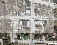
If you have access to an image editing program such as Adobe Photoshop, (that's what I am currently using) it isn't too difficult to do. I've used Adobe Photoshop on several occasions to take early 20th-century Sanborn Maps and overlay them on top of aerial images from the internet. Since aerial images and older maps are rarely created at the same scale, Photoshop allows you to stretch, shrink, scale plus, adjust the transparency of each image independently of the other. Here's an example of one that I've done recently. Is this the type of thing you're thinking about?

1912.jpg
 

doozis

Sr. Member
Jul 31, 2007
301
0
Virginia
Re: How to download maps & do overlays like Piggman1 did

Piggman's " finds " posts always look professionally produced !
he's the man :) If I tried to post a mint condition $20 dollar
gold piece it would probaby look more like carroded wheat penny :(

Doozis
 

piggman1

Silver Member
Apr 7, 2007
3,120
5
Austin, TX
Detector(s) used
Whites Eagle Spectrum, Compass X-100, Whites Beach Hunter ID, 2 Whites Spectrum XLT's
Re: How to download maps & do overlays like Piggman1 did

I put the complete instructions on a post this evening under "General Discussion". I gave step by step instructions so anyone can do it. If you have a problem with it let me know through PM and I'll help you out.
 

pgill

Bronze Member
Jun 4, 2005
1,258
22
Northampton, UK
Detector(s) used
Tesoro Silver Sabre II / Garrett Ace 250
Primary Interest:
Metal Detecting
Re: How to download maps & do overlays like Piggman1 did

Thanks Piggman1 ;D This is what this site is all about.

God bless you
Peter
 

pgill

Bronze Member
Jun 4, 2005
1,258
22
Northampton, UK
Detector(s) used
Tesoro Silver Sabre II / Garrett Ace 250
Primary Interest:
Metal Detecting
Re: How to download maps & do overlays like Piggman1 did

watercolor, how about giving us a tutorial on how you do your overlays? How do you make the top layer transpsarent for instance.

Great topic this.

God bless
Peter
 

piggman1

Silver Member
Apr 7, 2007
3,120
5
Austin, TX
Detector(s) used
Whites Eagle Spectrum, Compass X-100, Whites Beach Hunter ID, 2 Whites Spectrum XLT's
Re: How to download maps & do overlays like Piggman1 did

pgill said:
watercolor, how about giving us a tutorial on how you do your overlays? How do you make the top layer transpsarent for instance.

Great topic this.

God bless
Peter

No, you just draw on the original image in the Window's "Paint" program. There is no overlay. You can do it with ant pictures, and if you make a mistake you can't undo, just exit the program without saving changes and start over. Practice useing all the features of paint on any photo to get the hang of it.
 

pgill

Bronze Member
Jun 4, 2005
1,258
22
Northampton, UK
Detector(s) used
Tesoro Silver Sabre II / Garrett Ace 250
Primary Interest:
Metal Detecting
Re: How to download maps & do overlays like Piggman1 did

Thanks Piggman1, if you read Watercolor's entry above, he is talking about taking old maps and stretching them to size and then changing the transparency of the map which is on top off the new plan. This way you will be able to see what the place looked like many years ago.
I have also seen where people take a picture and import say a animal and place it in their picture. The animals background etc has been removed, just showing the animal. The final picture has been made from 2 pictures.

Not sure if you know what I am talking about ::) ;D

God bless
Peter
 

solaryellow

Jr. Member
Aug 26, 2007
82
18
Detector(s) used
Smart Tracker XR8 gift from dad as a kid, 1983?
Garrett Master Hunter CX/12" high energy hothead. R.I.P (1991-2013)
Re: How to download maps & do overlays like Piggman1 did

The google earth images are nice and work well when overlaying topo maps too.

I use photoshop.

Just open both images.

Drag the TOPO on top of the saved google earth image. helps to have the roads turned on.

Stretch topo as best you can to match roads on google image.
topo maps weren't exact, and lots of time you will see roads that have been moved, or no longer exist.


In photoshop just select the layers from (windows) pull down menus and highlight the topo frame.
Then just adjust the opacity to taste.

It's easier to compare high points and certain areas of topo maps when you have an actual satellite image with it.
 

pgill

Bronze Member
Jun 4, 2005
1,258
22
Northampton, UK
Detector(s) used
Tesoro Silver Sabre II / Garrett Ace 250
Primary Interest:
Metal Detecting
Re: How to download maps & do overlays like Piggman1 did

Thanks SolarYellow, that is what I was talking about ;D I will print your instructions out and then give it a try along with Piggman1's ideas.

God bless
Peter
 

piggman1

Silver Member
Apr 7, 2007
3,120
5
Austin, TX
Detector(s) used
Whites Eagle Spectrum, Compass X-100, Whites Beach Hunter ID, 2 Whites Spectrum XLT's
Re: How to download maps & do overlays like Piggman1 did

pgill said:
Thanks Piggman1, if you read Watercolor's entry above, he is talking about taking old maps and stretching them to size and then changing the transparency of the map which is on top off the new plan. This way you will be able to see what the place looked like many years ago.
I have also seen where people take a picture and import say a animal and place it in their picture. The animals background etc has been removed, just showing the animal. The final picture has been made from 2 pictures.

Not sure if you know what I am talking about ::) ;D

God bless
Peter

My mistake. :D I like his way of doing it. I've never tried that, but I'm going to now to see how well it works. Thanks Solar and Watercolor. We will give these a try.
 

Timberwolf

Silver Member
Sep 12, 2005
2,528
37
Detector(s) used
Eagle II SL90/Eagle Spectrum/TF-900
Re: How to download maps & do overlays like Piggman1 did

watercolor said:
Coin Hunter, I don't recall seeing Piggman's map so I'm really not sure of the type of overlays he used.

If you have access to an image editing program such as Adobe Photoshop, (that's what I am currently using) it isn't too difficult to do. I've used Adobe Photoshop on several occasions to take early 20th-century Sanborn Maps and overlay them on top of aerial images from the internet. Since aerial images and older maps are rarely created at the same scale, Photoshop allows you to stretch, shrink, scale plus, adjust the transparency of each image independently of the other. Here's an example of one that I've done recently. Is this the type of thing you're thinking about?

Watercolor,

That looks great!
I have Photoshop and can't figure out how to make a map (pic) transparent.
Do you have any suggestions?
Thanks in advance,

Timberwolf
 

piggman1

Silver Member
Apr 7, 2007
3,120
5
Austin, TX
Detector(s) used
Whites Eagle Spectrum, Compass X-100, Whites Beach Hunter ID, 2 Whites Spectrum XLT's
Re: How to download maps & do overlays like Piggman1 did

Timberwolf said:
watercolor said:
Coin Hunter, I don't recall seeing Piggman's map so I'm really not sure of the type of overlays he used.

If you have access to an image editing program such as Adobe Photoshop, (that's what I am currently using) it isn't too difficult to do. I've used Adobe Photoshop on several occasions to take early 20th-century Sanborn Maps and overlay them on top of aerial images from the internet. Since aerial images and older maps are rarely created at the same scale, Photoshop allows you to stretch, shrink, scale plus, adjust the transparency of each image independently of the other. Here's an example of one that I've done recently. Is this the type of thing you're thinking about?

Watercolor,

That looks great!
I have Photoshop and can't figure out how to make a map (pic) transparent.
Do you have any suggestions?
Thanks in advance,

Timberwolf

I'm having the same problem. Help needed. Thanks
 

Top Member Reactions

Users who are viewing this thread

Top