imafishingnutt
Bronze Member
- Sep 30, 2007
- 1,675
- 34
- Detector(s) used
- Whites XLT, Tesoro, Whites DFX, Nokta Impact Pro, Ace 400.
- Primary Interest:
- All Treasure Hunting
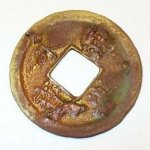
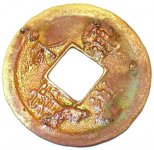
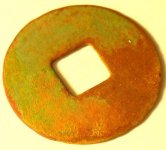
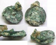
This is what I found today on a minus tide
i detected near the water on a minus tide where you cant normally detect
and this is what I found.
UPDATE I ADDED THE TWO CLOSE UPS OF THE COIN
IMA SO EXCITED
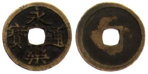
24.5mm
Obv.: Yung Lo T'ung Pao
Rev.: Nail Mark on top left
Rarity:
Ref.: Not listed
HOLY COW ,,,,,......Reign Title: Yung Lo (1408-1424 a.d.)
However, we must take into account that in Japan during the period 1587-1617
were cast coins with the same legend
Now I'm stoked
i detected near the water on a minus tide where you cant normally detect
and this is what I found.
UPDATE I ADDED THE TWO CLOSE UPS OF THE COIN
IMA SO EXCITED
24.5mm
Obv.: Yung Lo T'ung Pao
Rev.: Nail Mark on top left
Rarity:
Ref.: Not listed
HOLY COW ,,,,,......Reign Title: Yung Lo (1408-1424 a.d.)
However, we must take into account that in Japan during the period 1587-1617
were cast coins with the same legend
Now I'm stoked
THE COIN I FOUND...

THE ONE I FOUND RESEARCHING IT ON LINE...

THE ONE I FOUND RESEARCHING IT ON LINE...


Attachments


Upvote
3

")


 It does seem to have some differences than the ones you pictured as a match.


