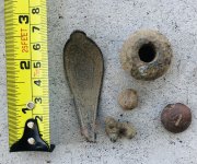
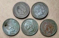
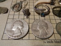
Gypsy Heart
Gold Member
http://www.treknow.com/charles-baker.htm
http://www.durangorvpark.com/Colorado Durango RV Parks bakers bridge.htm
http://www.mountainstudies.org/databank/history/Towns/Durango.htm
In the year Abraham Lincoln was elected President, a group of fifteen prospectors took the risks of encroaching into the hostile Indian Territory of the San Juans to search for gold (1860). Captain Charles Baker, after whom Baker's Bridge was named, led the contingent which divided itself into three groups as a strategy for survival. As the Baker expedition progressed towards Silverton, all five men in the middle group were killed by Ute Indians. For years, broken wagon parts and discarded camp equipment gave evidence of the Baker Party Trail. From the Pine River, it ran across C. E. Hampton's Ranch to the Florida River on the Edgemont Ranch and down to the north end of the Animas Valley to Baker's Bridge. 35 miles north of Baker's Bridge, along the Animas River, the prospectors made significant gold discoveries. As a consequence, a large number of persons flocked here the following year in the Spring of 1861. For the next thirteen years, the site of this short lived mini gold rush was known as Baker's Park. We know it as Silverton. The Baker Party spent the winter of 1860 - 1861 at Baker's Bridge and named their home Animas City. Six years later, an Army scouting party stumbled upon this original Animas City. In their report: "...within the Pine Forest on the North end of the Animas valley were found fragments of household, mining and cooking utensils, agricultural and other implements, scattered profusely in wild and lonely confusion through some 50 half decayed log houses spread over a clearing." The cabins were strung out on either side of a singular street for several hundred yards. Realizing the pioneers were intent on staying here with a permanent settlement, the hostility of the Indians exacerbated. With this threat to life and their luck playing out, the early prospectors evacuated very suddenly on July 3, 1861 - many answered the call to arms at this time of the inception of the Civil War. Baker was to become a Captain in the Confederate Army. The Baker men left as well, leaving their cache of concentrate buried up the river from Baker's Park (Silverton). They marked the site with trees; each member being given a map. The men who survived the war returned to hunt for the cache of gold but found that the miners who had since arrived had cut down the trees marked on their map. As far as this writer knows, the gold lies still buried. The Brunot Treaty opened this area for settlement in 1874. Seth Sackett was the first member of the Baker Party to return and settle here (1875). John C. Turner, "Jack", another member of the Baker party settled a homestead shortly thereafter with his wife and three small sons on the east side of the Animas. He was the only pioneer who was present at the founding of the first Animas City in 1861 and was also at the establishment of the second town of that name in 1876, 4 years before Durango was to come into existence. His relatives continue to live here today. By 1875 fifteen people were residing in the Animas Valley. On the north end, Baker's log cabin village stood very much as it was in 1861 nestled near Baker's Bridge. Judge Pinkerton and his family were the original homesteaders of the 160 acres south of Baker's Bridge spanning both sides of the river. The family used the logs from these cabins in building their log house and outbuildings on their homestead which became known as "Pinkerton Springs." One of the log cabins was moved and used as the first school house in the Animas Valley. The Pinkerton family brought in 30 head of cattle from Howardsville and sold dairy products to the five other families then living in the valley. They sold butter to Silverton residents in 1875 for $1 a pound. Thomas H. Wigglesworth, who contributed his invaluable skills as location and construction engineer for the railroads in this area, purchased Pinkerton Springs in the early 1880's. A civil war buddy and fellow colleague of General Palmer, T. C. Graden, (who later established Graden Mercantile) claimed the 160 acre homestead northwest of Baker's Bridge in 1881, setting up a sawmill to cut timber for the rails going to Silverton at Palmer's request. By October, 1879, a full year before Durango was established and announced to-be, Wigglesworth had already plotted the train's route from Durango to Silverton. He then surveyed a route for a railroad that was to follow Hermosa Creek up the divide to Rico, at the time an active stage route. Though property was purchased to serve as a railroad yard where the Hermosa water tank still stands, the railroad never materialized. Wigglesworth went onto to establish and play key roles in constructing the three railroads going north out of Silverton as well as the Rio Grande Southern which traversed from Durango to Rico and Ridgeway. For the Boston Fuel Co. Wigglesworth designed and constructed the railroad which spurred off Wildcat Canyon and up the back side of the Twin Buttes to the coal community of Perin's Peak. To remove the snow off the railroad tracks, especially heavy along Lizard Head Pass, Wigglesworth invented the railroad rotary snow blower which was pushed by several engines at a time, the only railroad plow of its kind in the world. A grandiose plan materialized in 1901 to ship Durango's coal south and join Durango by rail with Southern California. Having been paid by the citizens of Durango, Wigglesworth surveyed the best rail route from Farmington to Clifton, Arizona. The rails might well have been laid if not for the sudden death of E. H. Harriman, President of the mighty Southern Pacific and chief supporter of the proposal. Wigglesworth eventually purchased the Waterfall Ranch Homestead near Trimble Springs and for many decades thereafter the site of the original Animas City was known as the Harold C. Carter Ranch. For many years now, it has been owned by the Kroulik family.