Gypsy Heart
Gold Member
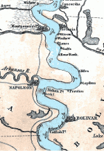
Here on the banks of the Mississippi River is the site of the town that no longer exists, Napoleon, Arkansas.
In the 1840s and 1850s, Napoleon was an important port for Mississippi River trade. Located in Desha County where the Arkansas River meets the Mississippi River, the town was the shipping point for much of the trade of southeastern Arkansas.
All river towns were wild and rowdy places in those days, and Napoleon had the reputation of being among the worst. One traveler called it the “most wretched of wretched places.”
Napoleon, located at a low place on the river bank, suffered regularly from floods. One newspaper reported that the town was often half underwater.
The beginning of the end for Napoleon came in the 1860s, during the Civil War. The Union forces, in control of the town, wanted a clear view of the river and any Confederate gunboats that might be passing by. Union soldiers dug a channel through an island that previously protected Napoleon from the worst of the Mississippi River currents, leaving the town completely at the mercy of the river.
Another 10 years of floods and swift current ate away the river bank on which the town was located. One by one, the town’s buildings toppled into the Mississippi. By the 1870s, all the buildings had been washed into the river, and Napoleon no longer existed.
xxxxxxxxxxxxxxxxxxxxxxxxxxxxxxxxxxxxxxxxxxxxxxxxxxxxxxxxxxxxx
[Not long after the Civil War the Arkansas River began to erode the site where Napoleon, Arkansas once stood. By 1874 what was left of Napoleon was abandoned to the river.]
Yes, it was an astonishing thing to see the Mississippi rolling between unpeopled shores and straight over the spot where I used to see a good big self-complacent town twenty years ago. Town that was county-seat of a great and important county; town with a big United States marine hospital; town of innumerable fights--an inquest every day; town where I had used to know the prettiest girl, and the most
accomplished in the whole Mississippi Valley; town where we were handed the first printed news of the Pennsylvania's mournful disaster a quarter of a century ago; a town no more--swallowed up, vanished, gone to feed the fishes; nothing left but a fragment of a shanty and a crumbling brick chimney!
- Life on the Mississippi
xxxxxxxxxxxxxxxxxxxxxxxxxxxxxxxxxxxxxxxxxxxxxxxxxxxxxxxx
Mississippi River Ruins Napoleon
ARKANSAS CITY – The floods of this unusually rainy spring of 1883 have completed the ruin of the old town of Napoleon, located on the Mississippi just below the mouth of the Arkansas. Passengers on boats which have passed the site recently report that all of the town except the cemetery and a few abandoned houses has been washed into the river.
The process of destruction was initiated in 1863, when Federal Army engineers dug a canal through a peninsula upstream from Napoleon and straightened a bend in the river. The increased force of the current began eroding the bank on which the town stood, and over the past twenty years the entire business district and most of the residential area has gradually slid into the river.
Napoleon was laid out in 1837 and became an important river port. A marine hospital for boatmen was located there from 1854 until the Civil War. Napoleon was the county seat of Desha County until 1874, when the seat of justice was moved to Watson after the jail and other county buildings caved into the river.
xxxxxxxxxxxxxxxxxxxxxxxxxxxxxxxxxxxxxxxxxxx
The Napoleon Cavalry, a company of the 6th Arkansas Militia (the Desha County Militia), was organized on February 28, 1861, at Napoleon, Desha County, Arkansas. After Arkansas seceded from the Union in May, the company reorganized as a volunteer company, known as the Napoleon Rifles, and rode to Fort Smith, where they enlisted in Confederate service as Co. G, 1st Arkansas Mounted Rifles, on June 15, 1861. New officers were elected on June 16. While stationed at Fort Smith, two killings occurred in the Napoleon Rifles on June 28, 1861. Lieutenant David Alexander, Jr., killed Private William Finnerty, and was subsequently court-martialed for murder. Private LeRoy Weatherford killed Corporal John Tinney, but was not court-martialed, and was later promoted to lieutenant.
The Napoleon Rifles served with the 1st Arkansas Mounted Rifles throughout the war, eventually surrendering with the Confederate Army of Tennessee in North Carolina in April 1865. One of its members, Private William S. Colburn was awarded the Confederate equivalent of the Medal of Honor for heroism at the battle of Murfreesboro.