Gypsy Heart
Gold Member
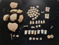
Fort L'Huillier...Trade Goods Cache Buried ...Mankato Minnesota
Fort l'Huillier
(1700 - 1702), Mankato
A French post established by Pierre Charles Le Sueur for trading and mining. Also known as Fort Vert. Abandoned due to Indian hostility. The site is located on a 70-foot high natural mound at the Minnesota and Blue Earth Rivers, now farmland. No trace exists of the fort
When the Frenchmen left it is said they buried a cache of all their trade goods....This has never been found.Fort Vert (also called Fort l'Huillier) near what is now Mankato, Minnesota. At Fort Vert, LeSueur was told about an Ioway village located 80 miles away, near a collection of lakes which drained into a river leading to the Missouri. He sent off a detachment to find them, but they failed to connect.
The embankment was called Fort L'Huillier, in honor of the royal contractor who helped organize Le Sueur's "Compagnie des Sioux." Even before the fort's construction was finished, the Dakota from the east protested. They said that since the fort was built on the territory that belonged to the Dakota from the west, they didn't think that they could engage in trade with Le Sueur without fear of being attacked by the western Dakota. The Dakota wept, asking Le Sueur to move to Mendota, the meeting of the waters. They cried, "Oueaechisson ouaepanimanabo," which means, "have pity on us."
Le Sueur, thinking of the copper that he hoped to find underneath his feet said that it was too late in the season to find a new location. He sent the Dakota ambassadors away with powder, balls, knives, and an armload of tobacco.
Charles Pierre Le Sueur and his crew spent the whole summer of 1700 traveling up the Mississippi. They traveled in two canoes and a small sloop, which was the first sailboat to enter Dakota territory. Le Sueur came with a party in 1700 in search for the legendary land of "blue earth," which he thought contained valuable copper. A miner, Penicaut, knew where he was going because on earlier trading ventures, he had been told of copper to be found on the Minnesota River. This journey was headed for "a stream that empties into the Mississippi from the left," not far from St. Anthony Falls in St. Paul; "they named this stream Riviere St. Pierre. We then made our way through the mouth of this river and ascended it for forty leagues and found another river on the left . . . We entered this and named it Riviere Verte on account of clay that, loosened from the copper mines, dissolves and turns the water green." Although it was only the end of autumn, ice had already formed on the river that is now called the Blue Earth.
In the spring of 1702 the time at Fort L'Huillier ended when a war party of Fox Indians chased D'Eraque out of the valley. The Foxes murdered three men, because they were angry that the French were trading with the Sioux. D'Eraque was out of ammunitions and supplies. He chose to abandon L'Huillier, the valley's first fort. He only stopped to hide what remained of his trade goods.
By then Le Sueur had sailed to France. No report of what the assayers of that time thought of his ore had been found, but George Featherstonhaugh dismissed it as "a silicate of iron of a bluish green color." Le Sueur found consolation for the failure on the Minnesota when he was named Lieutenant General of the jurisdiction of Mobile. Charles Pierre Le Sueur died in 1704 after contracting yellow fever on a transatlantic voyage.
No authentic artifacts of the two winters spent by the fur traders at the fort were found until the summer of 1904, when a local committee was enlisted to explore the site near the junction of the Blue Earth and the Minnesota River. Among the group was Judge Thomas Hughes, who noted in his report: "As the fort consisted of three or four log cabins enclosed by a log palisade, the timber used in its construction must have been conveniently obtained, since Le Sueur's party had no means to transport it except by hand." He placed Fort L'Huillier on the east bank of the Blue Earth River. He thought that they were mining on the south side of the Blue Earth River.
Some think that Fort L'Huillier was a real fort in the 1700s, but others believe it to be just a fable. They believe that it's just a fable because of the lack of evidence.
http://www.geocities.com/Athens/Acropolis/5894/Minnesota/pg528.JPG
............................
The three men with whom Monsieur Le Sueur had left orders, when he was at the Illinois, to take a canoe loaded with ammunition to Monsieur d'Eraque at Fort L'Huillier arrived at the fort of Monsieur de St. Denis; they greatly surprised Monsieur Le Sueur by informing him that, the canoe which they used having split, they had lost it, with all the ammunition, opposite Nicolas Perrot's mine. Messieurs de St. Denis and de Bienville immediately gave orders that they should lead a canoe with more ammunition and food, commanding them to use all possible diligence to arrive quickly at Fort L'Huillier. As for us, after we had unloaded from our shallop and canoes the peltries which we had obtained in trade with the Sioux, we went down the river a shallop with Monsieur Le Sueur, a few days later, to the fort of Biloxy, where we found Monsieur d'Iberville had arrived; he was still occuped with getting his ships unloaded.
http://www.perseus.tufts.edu/cgi-bin/ptext?doc=Perseus:text:2000.03.0134&query=page=#253
.......................................................................................
Towards the end of September, Le Sueur and his followers reached the mouth
of the St. Peter, which they ascended to Blue Earth River. Pushing a league
up this stream, they found a spot well suited to their purpose, and here
they built a fort, of which there was great need, for they were soon after
joined by seven Canadian traders, plundered and stripped to the skin by the
neighboring Sioux. Le Sueur named the new post Fort l'Huillier. It was a
fence of pickets, enclosing cabins for the men. The neighboring plains were
black with buffalo, of which the party killed four hundred, and cut them
into quarters, which they placed to freeze on scaffolds within the
enclosure. Here they spent the winter, subsisting on the frozen meat,
without bread, vegetables, or salt, and, according to Penecaut, thriving
marvellously, though the surrounding wilderness was buried five feet deep
in snow.
Band after band of Sioux appeared, with their wolfish dogs and their sturdy
and all-enduring squaws burdened with the heavy hide coverings of their
teepees, or buffalo-skin tents. They professed friendship and begged for
arms. Those of one band had blackened their faces in mourning for a dead
chief, and calling on Le Sueur to share their sorrow, they wept over him,
and wiped their tears on his hair. Another party of warriors arrived with
yet deeper cause of grief, being the remnant of a village half exterminated
by their enemies. They, too, wept profusely over the French commander, and
then sang a dismal song, with heads muffled in their buffalo-robes.
[Footnote: This weeping over strangers was a custom with the Sioux of that
time mentioned by many early writers. La Mothe-Cadillac marvels that a
people so brave and warlike should have such a fountain of tears always at
command.] Le Sueur took the needful precautions against his dangerous
visitors, but got from them a large supply of beaver-skins in exchange for
his goods.
When spring opened, he set out in search of mines, and found, not far above
the fort, those beds of blue and green earth to which the stream owes its
name. Of this his men dug out a large quantity, and selecting what seemed
the best, stored it in their vessel as a precious commodity. With this and
good store of beaver-skins, Le Sueur now began his return voyage for
Louisiana, leaving a Canadian named D'�raque and twelve men to keep the
fort till he should come back to reclaim it, promising to send him a
canoe-load of ammunition from the Illinois. But the canoe was wrecked, and
D'�raque, discouraged, abandoned Fort l'Huillier, and followed his
commander down the Mississippi. [Footnote: In 1702 the geographer De l'Isle
made a remarkable MS. map entitled _Carte de la Riviere du Mississippi,
dresse sur les Memoires de M. Le Sueur_.]http://www.fullbooks.com/A-Half-Century-of-Conflict-Volume-II1.html
...................................................................
map
http://www.davidrumsey.com/detail?id=1-1-28800-1120978&name=Floride++Delta+du+Mississippi+canal+