Cutthroat Gap Silver

RGINN

Gold Member
Oct 16, 2007
8,612
10,763
Summit County, CO
🏆 Honorable Mentions:
1
Detector(s) used
White's DFX, White's Classic 1 Coinmaster, Nokta Pointer
Primary Interest:
All Treasure Hunting
Since we're still snowed in I can't do much but read about treasure and research, so I'll share my info on a legend that is actually a fact. As usual, anything connected to treasure invites conjecture and argument, but I'll present the basics of the best info I have, and cite my sources. In December of 1832 a party of American traders, led by Judge W. C. Carr, were travelling from Santa Fe across the Texas Panhandle heading to Missouri. They were travelling along the South Canadian River (source says near present Lathrop, TX, but I can't find that town) when they were attacked by a group of Kiowas. After a long seige with two killed, the rest of the traders made their escape, leaving behind their gear and a large amount of Mexican silver money, maybe about $10,000 worth. The Kiowas took the stuff and some of the silver coins, which they beat into ornaments. Later on, some Comanches told them that was the white man's money, so the Kiowas returned to the battle site and dug around in the sand, and found a bunch more coins. The Set-tan tribal history calendar pictograph for winter, 1832-33, notes this event with a symbol for Black Wolf who was killed in the fight, and a coin with an eagle on it. In the late spring of 1833 the entire Kiowa tribe was camped near the mouth of Rainy Mountain Creek near present day Mt. View, OK. They had a brief scare when they found evidence of Osage raiders in the area, but everything calmed down after a few days. A large party of almost all the fighting men took off the fight the Utes, and the remainder of the group split up. One group, led by Ah-da-te, principal chief at the time headed southeast to Eagle Heart Springs, near the head of Cache Creek. After a couple of days, they headed over west to Saddle Mountain Creek, about a half mile from the present Saddle Mountain store. They moved once more to the west, through Cutthroat Gap, and set up camp there.
 

OP
OP
RGINN

RGINN

Gold Member
Oct 16, 2007
8,612
10,763
Summit County, CO
🏆 Honorable Mentions:
1
Detector(s) used
White's DFX, White's Classic 1 Coinmaster, Nokta Pointer
Primary Interest:
All Treasure Hunting
It was in this final camp that the Kiowas were massacred by Osage warriors. It was a total rout. The Osages cut off the heads of the dead, placed them in brass kettles, and lined them up in the village. The survivors ran west, and regrouped at a little hill about a mile northwest of the mouth of Elk Creek, known as Scratching Rock. The Osages beat it back east with over a hundred scalps, captive children, some horses, and some of the silver coins they had found in the camp. They took these to Ft. Gibson. The Kiowas told James Mooney, a researcher working among them, that they had buried some of the silver coins in Cutthroat Gap but nobody knew the exact location. Sources cited include W.S. Nye 'Carbine and Lance, the story of old Ft. Sill', Stan Hoig, 'Beyond the Frontier, Exploring the Indian Country', and Mildred P. Mayhall, 'The Kiowas'. That almost all I know about it. Interesting part of history and with more dedicated research has potential. Cutthroat Gap itself is out of the question. Locating the battle site in Texas might turn up something, but I will only speculate now that it was somewhere along the river between Lake Meredith and the Antelope Hills. That should help. The main camp area near Mt. View is well known and probably out of the question too. The camp at Eagle Heart Springs might be worth looking into, as well as the site west of Saddle Mountain. There was 'something' recovered at this site some years back, but I don't know if there's more. Scratching Rock would be interesting, but I doubt if anybody took much of anything with them when they were running for their lives. Thought it was a good tale, and good huntin to everybody in Oklahoma!
 

OP
OP
RGINN

RGINN

Gold Member
Oct 16, 2007
8,612
10,763
Summit County, CO
🏆 Honorable Mentions:
1
Detector(s) used
White's DFX, White's Classic 1 Coinmaster, Nokta Pointer
Primary Interest:
All Treasure Hunting
Dang. Apparently nobody in Oklahoma knows what the h*ll I'm talkin about in this post. I thought I'd get a little feedback.
 

Slim Diggins

Jr. Member
May 27, 2010
21
1
McLoud Oklahoma
Detector(s) used
White's MXT, DFX
Minelab CTX3030
Primary Interest:
All Treasure Hunting
This one puzzles me. I know in my travels I have passed thru or have seen a town "Lathrop" but where I don't know.
If it "is" or "was" in Texas, I can't find it either.
I'll keep researching this one.
 

OP
OP
RGINN

RGINN

Gold Member
Oct 16, 2007
8,612
10,763
Summit County, CO
🏆 Honorable Mentions:
1
Detector(s) used
White's DFX, White's Classic 1 Coinmaster, Nokta Pointer
Primary Interest:
All Treasure Hunting
Yeah Slim Diggins, I thought it would be an easy no brainer to go out and find Lathrop, but I came up with a lot of questions the more I checked into it. The Santa Fe trail and the Cimarron cutoff were established, so why would you take off and follow the Canadian across Texas into the heart of Commancheria and the Kiowas? Avoid the outlaws on the Santa Fe maybe? There is the possibility of a Lathrop in Woodward County, OK, along the North Canadian. The Kiowas patrolled all that area pretty much all the way over west to New Mexico. Everybody I've talked to has had general various ideas of where the original fight was, but they couldn't drive you to it. They're dead on about locations and what happened afterwards. Nye talked with people whose parents and grandparents were in that massacre, I lived with and talked to the next generations down. I put the story in legends, but it actually is historically documented as true.
 

Slim Diggins

Jr. Member
May 27, 2010
21
1
McLoud Oklahoma
Detector(s) used
White's MXT, DFX
Minelab CTX3030
Primary Interest:
All Treasure Hunting
I still haven't found the location of Lathrop.
I used to do alot of exploring in Beaver, Harper,
and Woods counties.

I'll keep looking.
David
 

Slim Diggins

Jr. Member
May 27, 2010
21
1
McLoud Oklahoma
Detector(s) used
White's MXT, DFX
Minelab CTX3030
Primary Interest:
All Treasure Hunting
Lathrop OK. was located due north of where the N.Canadian River runs under HI-412 east of Woodward.
Now if the ambush happened close to the river it could have been in the Woodward - Boiling Springs area. Maybe?
More info needed. I'd be willing to make a road trip to check it out.

I'm also looking for a site I saw about 20 yrs ago.
I visited a monolith which I thought was near the Buffalo area. But it maybe what is known as "Chimney Rock"
which is between Alabaster Caverns and Little Sahara. I won't know until I see it.
I really like exploring that NW corner of OK.

David
 

OP
OP
RGINN

RGINN

Gold Member
Oct 16, 2007
8,612
10,763
Summit County, CO
🏆 Honorable Mentions:
1
Detector(s) used
White's DFX, White's Classic 1 Coinmaster, Nokta Pointer
Primary Interest:
All Treasure Hunting
Thank you Dave, and that location makes sense to me. The fight supposedly took place right down on the river, and of course the river bed has changed many times over the years. It would be a good place to locate and look, cause maybe the Kiowas didn't find all the silver coins when they went back and looked. They did find a bunch, and turned a lot of it into ornaments.
 

Gooner

Full Member
Dec 23, 2010
155
30
Pawhuska, Oklahoma
Detector(s) used
white's xlt
RGINN I really enjoyed the story, and Dave, I heard that Oklahoma's chimney rock had fallen. Also it seems like I remember a story from Dobie's Coronado's Children from the same region involving the heads of Spaniards being left on the field of battle in brass buckets. The earlier Osage were notorious for scalping their victims and enemies, a habit they had acquired from the French when bounties were paid for scalps from braves of certain tribes. Of course creative cutting soon came into play and sometimes you could get two or three scalps from the head of a woman if you were artistic and imaginative.
-Bill
 

Last edited:
OP
OP
RGINN

RGINN

Gold Member
Oct 16, 2007
8,612
10,763
Summit County, CO
🏆 Honorable Mentions:
1
Detector(s) used
White's DFX, White's Classic 1 Coinmaster, Nokta Pointer
Primary Interest:
All Treasure Hunting
Good to see ya, okietreasurehunter. I've been in Cutthroat Gap legally, but we weren't lookin for treasure at the time. I do believe that some of that money was dug up west of Saddle Mountain in the early 1970's, but not by me. The original fight site, which was not in Cutthroat Gap, or Topaum Springs, or Scratching Rock, or even that camp site along the creek west of the Saddle Mountain store would be good spots to locate and check out, if permission could be obtained. I found it strange that of all the treasure tales passed down by certain members of my family, not one word about Cutthroat. That crazy uncle I had probably knew, but he would disappear into the Wichitas for a long time and didn't say much of anything to anybody about what he had been up to. In the last years I knew him he had a fixation on Flattop Mountain. I don't think he ever found much, but I bet he had a good time.
 

OP
OP
RGINN

RGINN

Gold Member
Oct 16, 2007
8,612
10,763
Summit County, CO
🏆 Honorable Mentions:
1
Detector(s) used
White's DFX, White's Classic 1 Coinmaster, Nokta Pointer
Primary Interest:
All Treasure Hunting
Well, stupid me. I have a lot, and I mean a LOT of reference books. I was reading through Josiah Gregg's 'Commerce of the Prairies', again, and there's his info on this incident. Since this trip took place in December-January, the traders took this route to avoid the weather on the plains in the northern route. Well, not much better, but you would have the breaks and the cliffs along the Canadian. Being in the winter, the threat of hostiles could be expected to be lower, but, in this case, could have been a good day, it was close to home, so what the hell, let's have a fight. There might not have been a fight, but the Kiowas probably thought the traders were Texan and not American. Fair game, pretty much as it is today. Gregg's description and the one provided by the Kiowas indicate the fight site was along the Canadian River, in Oldham County Texas, below Skunk Arroyo. Would be a cool place to check out.
 

OP
OP
RGINN

RGINN

Gold Member
Oct 16, 2007
8,612
10,763
Summit County, CO
🏆 Honorable Mentions:
1
Detector(s) used
White's DFX, White's Classic 1 Coinmaster, Nokta Pointer
Primary Interest:
All Treasure Hunting
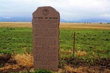
Pic I took when in Oklahoma the other day. 6-7c.jpg
 

oklhhyde

Greenie
Jul 16, 2012
15
1
Oklahoma city
Detector(s) used
Bounty Hunter Lone Star
Primary Interest:
All Treasure Hunting
I have actually been to the area where the massacre took place. There is a marker on the highway now and the actual place where the kiowas were killed is on privately owned property. There are a few houses around the area though and maybe someone in one of them could give you some info as to who to talk to. I also know that the town of Meers was a gold mining town long ago but not much was ever found there in the way of gold. Well not enough to be of any profit. Maybe this will help?
 

foolsgoldtx

Jr. Member
May 5, 2010
32
2
keep in mind that historical markers are not always put in the correct place...
i have not researched this myself, but probably 75% of the other stuff i have looked into that has a marker also has a history of that site being disputed.
actually in a couple there have been more than one markers erected

just something to keep in mind
 

oklhhyde

Greenie
Jul 16, 2012
15
1
Oklahoma city
Detector(s) used
Bounty Hunter Lone Star
Primary Interest:
All Treasure Hunting
The marker states that the massacre took place two and a half miles away from the marker. We drove two miles and ran into a dead end. We did some research on cutthroat gap and found we were extremely close to the massacre site but did not want to get into trouble for walking around somebody's private property.
 

oklahomaroper

Newbie
Jun 19, 2012
2
0
I was reading this thread and took note of the area around Woodward. I lived close to that spot, but at the time I had not been but by the treasure bug. I am hoping to get back to that area soon. It's great to see something I may actually be able to check out. Thanks for the info on this.
 

Libralabsoldier

Hero Member
Jan 7, 2007
666
23
Baker,LA
Detector(s) used
Garrett Ace 150
Hey Guys, I am back on, and guess what, RGINN? I live in Mountain View now. I am going to detect the new yard today, seeing as how I have found some really nice marbles and some 1920s/30s china and glass jars. Might have to go check out Rainy Mountain Creek.
 

OP
OP
RGINN

RGINN

Gold Member
Oct 16, 2007
8,612
10,763
Summit County, CO
🏆 Honorable Mentions:
1
Detector(s) used
White's DFX, White's Classic 1 Coinmaster, Nokta Pointer
Primary Interest:
All Treasure Hunting
I popped back in to look this over and good to see you Libralabsoldier. I'm pretty familiar with the Mt. View area, as I had relatives who lived there and live in Carnegie myself for about 3 years. Go down to Rainy Mountain and just north of there where the road turns might be a good place to detect. Lots of 49's held there and I attended a few in my wild younger days. (You live in Kiowa country, probably you know what a '49' is!) If you can find out who owns it, Oakdale up north of Mt. View would be a good spot to check out. And if nothin else, go out east of town and turn south on 115 and take a trip down to the mountains. Just a great Oklahoma back road.
 

Top Member Reactions

Users who are viewing this thread

Top