Gabriel Coxes Fort

Jrlevers

Jr. Member
Dec 29, 2011
38
0
Bentleyville, Pa
Detector(s) used
Tesodoro Compadre
Primary Interest:
All Treasure Hunting
Gabriel Coxe's Fort

I'm not entirely sure that this is the appropriate place to post this but I'm going to start here.

I've been doing a lot of research online trying to find local places to hunt. I've come across an interesting listing of Fort's/Blockhouses local to me and one in particular I find most interesting. Gabriel Coxe's Fort. It's very close to me and I have family in the immediate area that it is supposedly located. I'm trying to decipher the exact location of the Fort in my research and I'm having a hard time pinning it's location down.

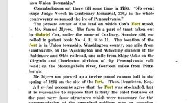
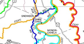
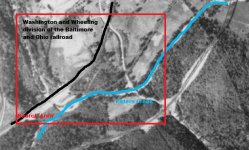
According to this book, "The location of the fort is in Union township, Washington county, one mile from Gastonville, on the Washington and Wheeling division of the Baltimore and Ohio railroad, one mile from Shire Oaks on the Virginia and Charleston division of the Pennsylvania railroad; on the Monongahela river, fourteen miles from Pittsburgh."

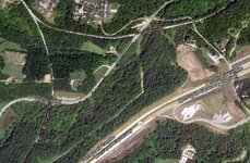
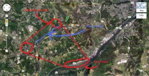
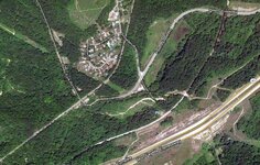
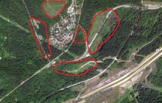
In the image of google maps I found a railroad near Peter's Creek and there IS a division in it. I'm having a hard time finding out if it's the correct railroad listed in the book. Can anyone lend some advice here? I don't know where to find the name of the railroad listed in the picture. Furthermore, once I can ID the railroads mentioned, how does one go about scanning the map for possible locations of the Fort? Thanks.

Map coord's 40.280115, -79.961822.
 

Attachments

  • Cox\'s Fort.JPG
    Cox\'s Fort.JPG
    72.4 KB · Views: 290
  • railroad peters creek.JPG
    railroad peters creek.JPG
    141.8 KB · Views: 322
OP
OP
Jrlevers

Jrlevers

Jr. Member
Dec 29, 2011
38
0
Bentleyville, Pa
Detector(s) used
Tesodoro Compadre
Primary Interest:
All Treasure Hunting
Re: Gabriel Coxe's Fort

I found a railroad map of active rails. One identified Shire Oaks on the Mon River. I already found the division of a railroad. Nearby is Gastonville. I've pinpointed it down to a triangle. Further advice?
 

Attachments

  • Coxe\'s Fort General Area.JPG
    Coxe\'s Fort General Area.JPG
    156.7 KB · Views: 306
  • RR Map.JPG
    RR Map.JPG
    71.3 KB · Views: 297

jeff of pa

Super Moderator
Staff member
Dec 19, 2003
85,769
59,548
🥇 Banner finds
1
🏆 Honorable Mentions:
1
Primary Interest:
All Treasure Hunting
Re: Gabriel Coxe's Fort

Here is the 1938 View of the area from Penn Pilot

New Image.JPG

http://www.pennpilot.psu.edu/

you'll need to open the High Resolution Image
to see better ground detail.

Without better Directions,
I'm guessing it overlooked the river,
From a hill.
but just a guess
 

OP
OP
Jrlevers

Jrlevers

Jr. Member
Dec 29, 2011
38
0
Bentleyville, Pa
Detector(s) used
Tesodoro Compadre
Primary Interest:
All Treasure Hunting
Re: Gabriel Coxe's Fort

that helps a lot. i've pretty much picked a spot where i feel the directions best point to.

"Washington and Wheeling division of the Baltimore and Ohio railroad" B&O Railroad is now run by CSX. I ID'd this segment by current railroad maps.

Another source says it was located on Peters Creek. This is the point where they were closest to each other.

Yet another source says that a canonball was dug up in 1892 by a plow. Assuming this was farmland for another 46 years according to this arial photo I've outline the probably place it once stood.
 

Attachments

  • best area to start.jpg
    best area to start.jpg
    76.9 KB · Views: 320
OP
OP
Jrlevers

Jrlevers

Jr. Member
Dec 29, 2011
38
0
Bentleyville, Pa
Detector(s) used
Tesodoro Compadre
Primary Interest:
All Treasure Hunting
Re: Gabriel Coxe's Fort

Unfortunately it looks like the only areas in this segment of map that were once fields are now covered by a housing development and a road development.

:BangHead:
 

OP
OP
Jrlevers

Jrlevers

Jr. Member
Dec 29, 2011
38
0
Bentleyville, Pa
Detector(s) used
Tesodoro Compadre
Primary Interest:
All Treasure Hunting
Re: Gabriel Coxe's Fort

This is the area today.
 

Attachments

  • area today.JPG
    area today.JPG
    129.1 KB · Views: 386

jeff of pa

Super Moderator
Staff member
Dec 19, 2003
85,769
59,548
🥇 Banner finds
1
🏆 Honorable Mentions:
1
Primary Interest:
All Treasure Hunting
Re: Gabriel Coxe's Fort

although I'm just going by ground Markings.
Nothing else
Places that would interest me.
Mainly because they look Altered

area_today.JPG

best_area_to_start.jpg

Add this in Blue.
Any Idea what that is ?

Island surrounded by Creek ?

best_area_to_start.jpg
 

OP
OP
Jrlevers

Jrlevers

Jr. Member
Dec 29, 2011
38
0
Bentleyville, Pa
Detector(s) used
Tesodoro Compadre
Primary Interest:
All Treasure Hunting
Re: Gabriel Coxe's Fort

I have no idea if that is an island or not. I would think that this creek isn't that wide by comparison with the roads. It may be interesting to look at that area and see if it is an island or not. I will definitely explore all the areas you've circled in red as well. That is, as soon as this snow melts.
 

OP
OP
Jrlevers

Jrlevers

Jr. Member
Dec 29, 2011
38
0
Bentleyville, Pa
Detector(s) used
Tesodoro Compadre
Primary Interest:
All Treasure Hunting
Re: Gabriel Coxe's Fort

I think once the weather settles down I'm going to focus on these areas. Hopefully something Pre-CW shows up in the finds. Thanks for the input!
 

Attachments

  • Search Areas.jpg
    Search Areas.jpg
    125.3 KB · Views: 595

jeff of pa

Super Moderator
Staff member
Dec 19, 2003
85,769
59,548
🥇 Banner finds
1
🏆 Honorable Mentions:
1
Primary Interest:
All Treasure Hunting
Re: Gabriel Coxe's Fort

Jrlevers said:
I have no idea if that is an island or not. I would think that this creek isn't that wide by comparison with the roads. It may be interesting to look at that area and see if it is an island or not. I will definitely explore all the areas you've circled in red as well. That is, as soon as this snow melts.

My definition of island here would be different then the standard Island
in a river, Lake, or Ocean.

My definition of an Island here is an area surrounded by Creek
on all sides. Creek could be narrow enough to wade through
and still have an Island

Example Island

schuylkill_outside_gis-apps34203280133372.jpg

it May also be an Island between 2 Roads
old & New Route

schuylkill_outside_gis-apps34204044133461.jpg
 

doverturtle

Sr. Member
Apr 23, 2010
398
233
York County, PA
Detector(s) used
Tesoro Tejon; Garrett AT Pro; Garrett Infinium; XP Deus; Minelab Excalibur 1000
Re: Gabriel Coxe's Fort

Your article has the tract number and patent book page numbers. I would try to determine the actual site by researching that information, maybe through your local tax agency.
 

OP
OP
Jrlevers

Jrlevers

Jr. Member
Dec 29, 2011
38
0
Bentleyville, Pa
Detector(s) used
Tesodoro Compadre
Primary Interest:
All Treasure Hunting
Re: Gabriel Coxe's Fort

Here is the full text as I found it. I'm not sure if this book is recorded in Va or Pa considering SW PA was once under control of Virginia.

COX'S FORT OR STATION.

Mention is made of Cox's, (or Coxe's) Fort or Station frequently in the latter days of the Revolution, but it was in existence much earlier. Gabriel Cox, from whom the fort was named and on whose land the fort was built and the station established, was a Major under authority of Virginia from 1776 to 1782; and was a participant in various expeditions that went out from the Washington county region against the Indiana from 1778 to 1782. [History of Washington County, Crumrine, 961.]

In Dunlevy's declaration for a pension, as recited in a note to Mr. Butterfield's Crawford's Expedition, it is said: "Dunlevy volunteered about the first of March, 1778, for one month's service. The rendezvous was at Cox's Station, on Peter's creek. Colonels Isaac Cox and John Canon attended to organizing the men; but in eight days the militia relinquished their arms to some recruits for the regular army, who relieved them, and they returned home to attend to putting in their crops."

In mentioning the early settlers of Peters township (then embracing Union township), in the History of Washington County edited by Mr. Crumrine, it is said that "David Steele was in service in 1776 under Captain Isaac Cox, and himself rose to the grade of Captain. On the 1st of March, 1778, he was with the troops who rendezvoused at Cox's Station, under Colonel Isaac Cox and John Canon."

During the time that Virginia exercised jurisdiction over this portion of the State this was a notable point and is frequently mentioned in their records and in the minutes of their county courts. "Commissioners appointed by Virginia for the adjustment and settling titles of claimants to unpatented lands ‘came to the western watters' in the Monongahela Valley in December, 1779, and in that and the following months sat at Redstone and at Cox's Fort, on the Monongahela, and granted scores of certificates to claimants under Virginia settlement rights."

Mr. Crumrine in a note to this text says: "There has been some doubt as to the locality of Cox's Fort. Mr. Veech calls it "Coxe's Fort, on the west side of the Monongahela." Some of the certificates are dated at Coxe's Fort, others at Cox's Fort, evidently meaning the same place. There was a Cox's Fort just above Wellsburg, on land about 1785 bought of Van Swearingen, but the locality called by this name in the text is believed to be the station or fort at Capt. Gabriel Coxes, in now Union Township."

Commissioners sat there till some time in 1780. "No event (says Judge Veech in Centenary Memorial, 336,) in the whole controversy so roused the ire of Pennsylvania."

The present owner of the land on which Cox's Fort stood, is Mr. Samuel Myers. The farm is a part of tract taken out by Gabriel Cox, under the name of Coxburg, Number 486, enrolled in patent book No. 4, P. 9 to 11. The location of the fort is in Union township, Washington county, one mile from Gastonville, on the Washington and Wheeling division of the Baltimore and Ohio railroad, one mile from Shire Oaks on the Virginia and Charleston division of the Pennsylvania railroad; on the Monongahela river, fourteen miles from Pittsburgh.

Mr. Myers son plowed up a twelve pound cannon ball in the spring of 1892 on the site of the fort. (Thos. Denniston. Esq.)

All verbal accounts agree that the Fort was stockaded, but it is reasonable to suppose that latterly the chief features of the post were those structures which were necessary for the accommodation of the organized soldiery who on occasion were stationed here.
 

jeff of pa

Super Moderator
Staff member
Dec 19, 2003
85,769
59,548
🥇 Banner finds
1
🏆 Honorable Mentions:
1
Primary Interest:
All Treasure Hunting
Re: Gabriel Coxe's Fort

is that from Report of the Commission to Locate the Site of the Frontier Forts of Pennsylvania ?
originally published In 1896 ?

if it is, that's when Mr. Samuel Myers lived there
 

OP
OP
Jrlevers

Jrlevers

Jr. Member
Dec 29, 2011
38
0
Bentleyville, Pa
Detector(s) used
Tesodoro Compadre
Primary Interest:
All Treasure Hunting
Re: Gabriel Coxe's Fort

jeff of pa said:
is that from Report of the Commission to Locate the Site of the Frontier Forts of Pennsylvania ?
originally published In 1896 ?

if it is, that's when Mr. Samuel Myers lived there

yes. i figured i could try and find him tax records. Caldwells Atlas of 1876 doesn't have a Myers on the map that I can decipher.
 

jeff of pa

Super Moderator
Staff member
Dec 19, 2003
85,769
59,548
🥇 Banner finds
1
🏆 Honorable Mentions:
1
Primary Interest:
All Treasure Hunting
Re: Gabriel Coxe's Fort

your going to have to get closer to '96
 

OP
OP
Jrlevers

Jrlevers

Jr. Member
Dec 29, 2011
38
0
Bentleyville, Pa
Detector(s) used
Tesodoro Compadre
Primary Interest:
All Treasure Hunting
Re: Gabriel Coxe's Fort

jeff of pa said:
your going to have to get closer to '96

any records you know of? i used ancestry.com before to look up genealogical stuff on my family and the founders of bentleyville so that may be a resource. of course i didn't want to pay $12/mo just to use it.
 

jeff of pa

Super Moderator
Staff member
Dec 19, 2003
85,769
59,548
🥇 Banner finds
1
🏆 Honorable Mentions:
1
Primary Interest:
All Treasure Hunting
Re: Gabriel Coxe's Fort

only thing I can suggest is Google County Atlas, or Township Atlas
for the area & see if one comes up from the 1890's
alot of times the atlas's have home owner names.

Only one I can think of would be Beers atlas, but if
a beers Atlas exists for that area it would be too early
1870's

But there may be an 80's or 90's atlas
even a 1900 to 1910 era atlas would have his name yet.
 

doverturtle

Sr. Member
Apr 23, 2010
398
233
York County, PA
Detector(s) used
Tesoro Tejon; Garrett AT Pro; Garrett Infinium; XP Deus; Minelab Excalibur 1000
Re: Gabriel Coxe's Fort

any records you know of? i used ancestry.com before to look up genealogical stuff on my family and the founders of bentleyville so that may be a resource. of course i didn't want to pay $12/mo just to use it.
[/quote]

I believe that many libraries have free access to ancestry.com. You may want to try that.
 

Mingo Ghost

Newbie
Jan 20, 2023
1
0
Re: Gabriel Coxe's Fort

Here is the full text as I found it. I'm not sure if this book is recorded in Va or Pa considering SW PA was once under control of Virginia.

COX'S FORT OR STATION.

Mention is made of Cox's, (or Coxe's) Fort or Station frequently in the latter days of the Revolution, but it was in existence much earlier. Gabriel Cox, from whom the fort was named and on whose land the fort was built and the station established, was a Major under authority of Virginia from 1776 to 1782; and was a participant in various expeditions that went out from the Washington county region against the Indiana from 1778 to 1782. [History of Washington County, Crumrine, 961.]

In Dunlevy's declaration for a pension, as recited in a note to Mr. Butterfield's Crawford's Expedition, it is said: "Dunlevy volunteered about the first of March, 1778, for one month's service. The rendezvous was at Cox's Station, on Peter's creek. Colonels Isaac Cox and John Canon attended to organizing the men; but in eight days the militia relinquished their arms to some recruits for the regular army, who relieved them, and they returned home to attend to putting in their crops."

In mentioning the early settlers of Peters township (then embracing Union township), in the History of Washington County edited by Mr. Crumrine, it is said that "David Steele was in service in 1776 under Captain Isaac Cox, and himself rose to the grade of Captain. On the 1st of March, 1778, he was with the troops who rendezvoused at Cox's Station, under Colonel Isaac Cox and John Canon."

During the time that Virginia exercised jurisdiction over this portion of the State this was a notable point and is frequently mentioned in their records and in the minutes of their county courts. "Commissioners appointed by Virginia for the adjustment and settling titles of claimants to unpatented lands ‘came to the western watters' in the Monongahela Valley in December, 1779, and in that and the following months sat at Redstone and at Cox's Fort, on the Monongahela, and granted scores of certificates to claimants under Virginia settlement rights."

Mr. Crumrine in a note to this text says: "There has been some doubt as to the locality of Cox's Fort. Mr. Veech calls it "Coxe's Fort, on the west side of the Monongahela." Some of the certificates are dated at Coxe's Fort, others at Cox's Fort, evidently meaning the same place. There was a Cox's Fort just above Wellsburg, on land about 1785 bought of Van Swearingen, but the locality called by this name in the text is believed to be the station or fort at Capt. Gabriel Coxes, in now Union Township."

Commissioners sat there till some time in 1780. "No event (says Judge Veech in Centenary Memorial, 336,) in the whole controversy so roused the ire of Pennsylvania."

The present owner of the land on which Cox's Fort stood, is Mr. Samuel Myers. The farm is a part of tract taken out by Gabriel Cox, under the name of Coxburg, Number 486, enrolled in patent book No. 4, P. 9 to 11. The location of the fort is in Union township, Washington county, one mile from Gastonville, on the Washington and Wheeling division of the Baltimore and Ohio railroad, one mile from Shire Oaks on the Virginia and Charleston division of the Pennsylvania railroad; on the Monongahela river, fourteen miles from Pittsburgh.

Mr. Myers son plowed up a twelve pound cannon ball in the spring of 1892 on the site of the fort. (Thos. Denniston. Esq.)

All verbal accounts agree that the Fort was stockaded, but it is reasonable to suppose that latterly the chief features of the post were those structures which were necessary for the accommodation of the organized soldiery who on occasion were stationed here.
Hello, I’m new here I saw this 10+ year old post, created a profile to offer this. The location as I knew it in my youth is southeast of where you located it on the map at the headwaters of Lobbs Run. As for the above mention of “Myers Farm” finding a cannonball? See at the bottom on the above post “(Thos. Denniston. Esq.)”, this Myers lot would become the Denniston Turkey farm whose family name appears on many maps. There stood the remains of a spring house Sandstone years ago and there were a few photos online. I hunted small game there years ago and knew the owners of the adjoining farm at that time who have now sold parcels multiple times and no longer own it. They too had several cannonballs. It located at the intersection on 3-4 modern parcels. As a side note I’ve long held the belief the choosing of this location made sense. If you follow Lobbs Run towards the River you’ll find Lobbs Cemetery and the former location of the short lived Yohogania County Virgina Courthouse.
 

Top Member Reactions

Users who are viewing this thread

Top