.
You are using an out of date browser. It may not display this or other websites correctly.
You should upgrade or use an alternative browser.
You should upgrade or use an alternative browser.
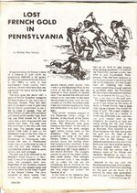
LOST FRENCH GOLD
- Thread starter jeff of pa
- Start date


OP
OP
- Thread starter
- #2
Rubicon
Sr. Member
This one's on my to-do list. I've been contemplating it for some time.
Potter Poker
Full Member
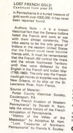
Jeff, thanks for posting this article. I have been doing research all winter on this buried gold, by trying to locate this mysterious "rock" in the Borie area. According to the Curator of the Potter County Historical Museum in Coudersport, that large rock was destroyed by dynamite...this info comes from an old lady who used to live in the area many years ago. The lady died some years ago, but when the current Curator was young and teaching in schools way back in the 50's and 60's, he said that she told him where that rock was and that it had been destroyed way back when the State Highway Dept. was working on the road from Coudersport to Austin. This is the info that the Curator told to me just a couple of weeks ago. Yet, I have found someone in the Clearfield area who says he "knows where that rock is and it is very large and has a cross carved on it and has some other strange writing on it" and he says "he will take me to it this summer"...such is life in the "treasure hunting detective" work. One doesn't know exactly what to believe. I am still pursuing the issue. I am now trying to find someone who used to work for the state back then who might be able to tell me exactly where it was on the road to Austin that they used dynamite to blow up a large rock. Anyway, I'm still doing research and detective work on this matter. Any help you could offer regarding this story, please let me know...potter poker
simonds
Sr. Member
Hey Potter,
I have noticed that sometimes, A person claims they have found a certain treasure or object. Often they have never even been to the area. When in reality they have found it at there kitchen table using some form of dowsing instrument. Maybe a needle or a weight on a string over a map of the area. I cannot say if this works or not. But just something to be aware of. I don't like to rule out anything until I can actually see proof of it.
Good luck in your hunting
Rubicon
Sr. Member
"Remote Viewing" was government subsidised and proven to work several years ago. I know it's a bit of a stretch, but then the find would certainly make it worthwhile! Just my 2 cents.
Potter Poker
Full Member
Rubicon...in what sense do you mean "Government subsidized"...(hummm...maybe the Gov. would pay me to a "remote viewing expert??")
Rubicon
Sr. Member
Operation "Stargate" was a government program to delve into the possibility of remotely "seeing" places in the human mind. Once trained, viewers were asked to describe specific details about a distant location or describe where a person or object was located. X-Files stuff, but true!
Potter Poker
Full Member
Thanks Rubicon, think I will look into this "operation Stargate"...wonder what they discovered so far??
gods country girl
Full Member
- May 18, 2007
- 213
- 12
- Detector(s) used
- whites mxt
- Primary Interest:
- All Treasure Hunting
i am new to this site and new to MD'ing .Thought i'd put in my 2 cents on this one.I have been interested in this legend for sometime , and i do not think it is in the valley that is now known as Borie, it is to far from the headwaters of the Allegany, and i doubt they would have hauled the kegs that far overland .
Just my 2 cents anyway
GCG
Just my 2 cents anyway
GCG
Potter Poker
Full Member
Hey God's Country Girl, I agree with you on the "Borie" gold. During the time the Frenchmen were through there, the area was not listed as "Borie", however, it was "near the headwaters of the Allegheny"...relatively speaking.... The focal point of a search should be that rock with a "cross" marked on it. I have been doing research on this subject for a few months now out of the Potter County Historical Society and Museum. Currently I believe that rock was located some 2 or 3 miles West of the Borie area, near what is now the road between Coudersport and Austin. However, further research tells me that that rock was destroyed in the 1920's when road work was being done. If you have further interest in this subject, send me an e-mail message...potter poker
double barrel
Jr. Member
- Jul 11, 2006
- 30
- 3
this is a good one. the area is supposed to be in borie vally, in the late 1600's. they were supposed to take that creek right before warren. why did they travel 50 miles or so east? and to top it off,borie is past coudersport maybe 10 miles or so by river route. according to my book, route 44 runs right alongside the southern stream to borie. you should be able to see that rock, unless this is the road they really mean where the rock was destroyed. i was headed that way today via back roads, got lost and ended up in austin. so we went to roulette to check out halfway hollow, which is now hanson hollow, and it is all posted and i do mean all. but there are some old foundations there. but to get back on track a person needs to find out where these authors get there info from.
gods country girl
Full Member
- May 18, 2007
- 213
- 12
- Detector(s) used
- whites mxt
- Primary Interest:
- All Treasure Hunting
As i said in a previous post , i don't think it is in Borie valley.I am thinking it is closer to coudersport.I grew up in between Austin and Coudy ( southwoods ) and i do not remember any rocks that large out that way.Or any that could have been that large.
GCG
GCG
double barrel
Jr. Member
- Jul 11, 2006
- 30
- 3
let's say cornplanter wouldn't let them go up the conawango, so they went further north up the allageny. still being harassed by cornplanter, they went south down the allegheny.here north of port allegany is a marshland maze. at the head of that is rock run, at sartwell on 155. near the head of the allegany, due to narrowing of the river where arrows can easily reach the rafts.
Potter Poker
Full Member
Hey Double Barrel, your post of May 19 states that Halfway Hollow is now called Hanson Hollow. Could you tell me where that info stems from? I have always thought the name "Halfway Hollow" was lost over time, as it does not appear on any map (new or old) that I have seen. My research so far with the PC historical society has revealed to me the location of a small hollow where Dabole Hare used to live, and it seems at this point in time that it was not where Hanson Hollow is today. Can you shed any further light on this matter Thanks, potter poker
Thanks, potter pokerBobPA
Sr. Member
- Feb 18, 2007
- 259
- 2
- Detector(s) used
- Excalibur 1000, JW Fisher Pulse 8X
Back in the early 1980's, I was hunting spring gobbler in Austin,Pa. To pass the time in the afternoon, I was metal detecting at the campground where I was staying. The lady that owned the campground told me the same story about the highway department and dynamiting the rock.
Bob
Bob
Potter Poker
Full Member
Bob of Pa....Do you happen to remember the name and location of that campground, and the name of the lady that told you that? The reason I ask, is that I also heard of a lady that knew where that rock was and many years ago she told Bob Currin of the PC Hist. Soc. where it was located. The lady's name I am familiar with is Swanson. She has past on many years ago, but she knew a lot about this county and a lot about the people who lived here even before her time....potter poker
gods country girl
Full Member
- May 18, 2007
- 213
- 12
- Detector(s) used
- whites mxt
- Primary Interest:
- All Treasure Hunting
If the Rock Run there near Sartwell is like the Rock Run here it is full of very large rocks.I am wondering if they buried it in a valley with lots of large rocks wouldn't that also be mentioned in the legend?Perhaps that is another reason they could not find it when they went back to look.I have an area in mind i need to check on near Coudersport, there used to be a HUGE rock and it is close to the Allegany
double barrel
Jr. Member
- Jul 11, 2006
- 30
- 3
potter poker, a guide to treasure in penna. by michael henson. speaks of it being in sartwell creek in potter co. first road on right.
double barrel
Jr. Member
- Jul 11, 2006
- 30
- 3
gods country girl, that mckean co. is just a hypothisis. i don't know how many valleys up there have large boulders, that could be an extensive search. but if people have heard of it being destroyed, dept. of highways or army corp of engineers may have contractors names who built the highway. i'm going to try to get back up there this week to do some research on the land grants, but i don't think they go back that far,we'll see.
Top Member Reactions
-
 2584
2584 -
 1138
1138 -
 1059
1059 -
 900
900 -
 883
883 -
 846
846 -
 805
805 -
 695
695 -
 633
633 -
 548
548 -
 489
489 -
 477
477 -
 477
477 -
 464
464 -
 462
462 -
O
432
-
 425
425 -
 391
391 -
 380
380 -
 361
361
Users who are viewing this thread
Total: 2 (members: 0, guests: 2)