Mexican Eds buried jars - Grindstone, SD

Dirt_Diver

Newbie
Dec 21, 2014
4
1
SE South Dakota
Detector(s) used
Tesoro Silver U-max
Primary Interest:
All Treasure Hunting
Mexican Ed's buried jars - Grindstone, SD

Greetings to all who read this,

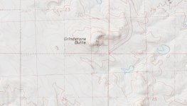
I stumbled across a very fascinating article set in the late 1800's about Grindstone, SD and the Roadhouse owner Mexican Ed. Was wondering if anyone here has any information about the story. I've done some research, but my main confusion right now is that the location of the town (according to today's spot) doesn't seem to match the location from personal documented accounts of that time. Anyway, just wanted to put some feeler's out there and see what, if anything, popped up. Look forward to any insight in the matter, and maybe teaming up for a spring time hunt?

Best regards,
JD
 

RockRaven

Jr. Member
Jan 19, 2015
77
55
South Dakota
Detector(s) used
Compass Challenger X80, Magnum 420, 220, RM6, Coin Mag, 77B, Yukon Nugget, Teknetics Delta 4000, Garrett AT Gold. Master Hunter ADS 7, CXII, Bounty Hunter Big Bud Pro 220, TR550, 840 Auto , Whites MXT
Primary Interest:
Prospecting
West of Grindstone to Dirty Woman Creek, then northeasterly along the creek, described as the Grindstone Buttes, Haakon county. 24 years he buried fruits jars of money up to several times a month, took no more than an hour to make the journey. Probably on private land, I will have to check my Buffalo Gap grasslands map just in case...

Edit: Looking at Google maps it would appear that the location does not jive with the reports as you stated. To the west and then northeast there are no buttes, and no creek. Here is a link to a geomorphology site for this area of Haakon county. Cheyenne River-Bad River drainage divide area landforms, South Dakota, USA ? Missouri River drainage basin landform origins research project

I grew up in SE south dakota, live in the northern black hills now. Great to see a recent post from a fellow digger!

MW
 

Last edited:

RockRaven

Jr. Member
Jan 19, 2015
77
55
South Dakota
Detector(s) used
Compass Challenger X80, Magnum 420, 220, RM6, Coin Mag, 77B, Yukon Nugget, Teknetics Delta 4000, Garrett AT Gold. Master Hunter ADS 7, CXII, Bounty Hunter Big Bud Pro 220, TR550, 840 Auto , Whites MXT
Primary Interest:
Prospecting
Looks like Dirty Woman Creek is around 3 miles straight north of where Google map shows the current location. This would make the one hour trip highly improbable for a normal person on foot - round trip minimum six miles, also you would not hit the creek if you headed west, it would be northeast of town at its closest, and the creek seems to run NW to SE - therefore it would be difficult to follow the creek in a north-easterly direction. State geological survey quadrant maps may be the best bet for a good look at the local topology. Good luck!
 

goodie hunter

Jr. Member
Jul 24, 2011
60
12
Beautiful Black Hills of South Dakota
Detector(s) used
Strictly Garrett
First off, the jars of Mexican Eds coins have been found several years ago. That is all I wish to divulge of that. I do know the Grindstone area quite well.

Grindstone,S. Dak. (Haakon County)

Wasfirst established as a stage coach station on the Deadwood Trail in1876, and was named for the near-by Grindstone Buttes. On a modernmap, Grindstone was located on the east side of now 206[SUP]th[/SUP]Ave, just south of its intersection with 225[SUP]th[/SUP] St.


GrindstoneButtes (Haakon County)
GrindstoneButtes is but a summit in Haakon County with an elevation of only of2595 ft., located East of 214[SUP]th[/SUP] Avenue & North of 10Mile Road.

The Buttes are not very high only listed as the 417[SUP]th[/SUP]highest summit in South Dakota. The elevation of Grindstone is only2470', making the Buttes only small hills.


Lyingin the west central part of the county. The first theory was theywere so named because they are covered with an outcropping of coarsesandstone, which resembles grindstones and were so used by Indians.The second theory of the naming was that the Buttes took their namefrom a waitress in a near by frontier cafe, who was called“Grindstone Carrie”. The weight of the local opinion favors thefirst theory.


DirtyWoman Creek
Risesin the extreme eastern end of Pennington County and flows southeastinto Haakon County to join the North Fork of Bad River.
 

Tiredman

Bronze Member
Oct 15, 2016
2,311
1,486
Primary Interest:
Other
He lived on the Sanchez ranch close to the pictured Butte. Grindstone Butte p162.jpg
 

Tiredman

Bronze Member
Oct 15, 2016
2,311
1,486
Primary Interest:
Other
I would forget the part about Dirty Woman Creek, just west of Grindstone Butte is Mexican Creek which is within the hour walking distance claimed. I also have the article on his being killed.
 

Top Member Reactions

Users who are viewing this thread

Top