Silver mine that assayed 1000oz to the ton map included

kenmor

Jr. Member
Jan 28, 2006
40
14
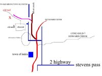
Ok I was dating a lady in the Seattle area,her father was a postal worker,he had a friend who was a avid prospector,somehow he found a high grade of silver and when he was almost dead he gave this lady I was dating a map,and directions,here is the directions,go to index washington and go to the old silver creek road, travel up the silver creek road until you come to where the bridge washed out,to the left is a clear cut,there is a trail along the small creek that goes through the clear cut.He told her dad it was at that time that he was working it staked out, in other words he was mining someone claim,he said to watch for wheelbarrow tracks coming out of the weeds on the left going up.I never got around to go looking but the map was simple and I reproduced it here from memory,by the way,there is a old town site just after you cross silver creek named Galena,and all the way up the silver creek road is the old town site called silver creek. I under stand that the road is blocked with a slide and you have to walk the old silver creek road,there is a lot of mines in that area,be careful, regards....Ken Morrison
 

Attachments

  • silver mine location.jpg
    silver mine location.jpg
    34.7 KB · Views: 712

lgadbois

Sr. Member
Mar 20, 2003
299
253
Here are some corrections to the previous post:

While Eastbound on Hwy 2 to Stevens Pass, turn left onto the Index-Garland Hot Springs Road. Do not cross the bridge into town, but continue straight ahead. It is about eight miles to Galena. You may not be able to drive there as the road was damaged by river flooding. I do not know if the road has been repaired yet. It is still possible to hike or bicycle the distance. The site can also be accessed by taking the Jack Pass Road on the left just passed Skykomish. This road follows the Beckler River to the pass summit, and then winds down to complete a loop with the Index Road. This road may also be closed. Information on the roads can be obtained at a Ranger Station.

There is a concrete bridge that crosses the N. Fork at Galena. Across the bridge to the right is the road that follows along Silver Creek all the way to the townsite of Mineral City. The road is about four miles in length. It is closed just a short distance beyond the bridge. There have been multiple slides along this road and the road bed is totally gone in places. There are two wooden bridges that have also been destroyed along the way. Some of the property on either side of the road is privately owned or under mineral claims.

The clear cutting of old growth timber that occured during the mining period and the logging of the second growth timber in the 1950s and later did create some clear cuts. Those clear cuts are no longer visible as mother nature is renewing the forest.

Many old mines are in the area. In the early days of Mineral City, there was no road from Silver Creek to Index. Ore from the mines was packed out by mule along "Jack Ass Pass" to Skykomish where it was shipped by rail to the smelter.

More information can be found at:
http://www.trimbleoutdoors.com/ViewTrip/642061
 

jt_mcneal

Newbie
Oct 15, 2018
1
0
Primary Interest:
All Treasure Hunting
silver mine details

so it's been a while since this was posted and i checked it out on google maps to see it's a state park now, was it a state park when you posted this? also is there any updates since then, has anyone found anything over there since this has been posted? also just to confirm the guy found silver, did he keep what he found? did he leave any behind or what? i'll head out there and go search if i can get a little more info. email me if i don't respond on here or if you may know any other areas, if i find anything it would be split with whoever tell's me about it. [email protected]
 

Top Member Reactions

Users who are viewing this thread

Top