directions to "la tarasca " and "la pima" mines

lilorphanannie

Full Member
Apr 19, 2008
173
517
directions to "la tarasca " and "la pima" mines

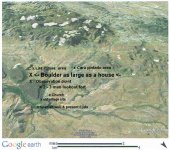
el chapo coyote, a yaqui indian, is apparently the last person on record to claim to know the location of these two famous lost mines .this is a loose translation, by me, of his account. the year was 1954. "when we were hard up for money, we would go to a mine every now and then to take out gold ,in order to buy weapons and provisions. a few of us would always stay above (up at a vantage point) as lookouts, while the others would go down below to extract the gold." go to the watering hole for la pintada (la pintada is a ranch,the nameplace still existant on maps) (the watering hole may now be called "la tinaja del carmen",tinaja means tank as in a natural water tank. " look carefully at the branches of the bushes around the watering hole, you will see some that have been trampled ,died and new ones sprung up in their place. its that we had made a path ,where we would go down and get water. follow that path we made to the highest point of the sierra.then start heading down on the other side (staying on that path) at the same time keeping on the lookout up ahead for deep canyon in the distance.if you get this far you're bound to find it. continue to walk heading south , looking above as you continue ,look for two sheer faced overhangs, stop and look down below. doubtless ,you will see a very big stone(the size of a house) start heading toward that rock ,go around behind it looking for a mine tunnel entrance, this is the entrance to la pima gold mine. if you follow the canyon as it runs out away from the mountain you will see another mine workings ,this is the tarasca. worked in 1580. this is in the stare of sonora ,mexico,48 km south of the capital ,hermosillo. in a group of hills called "sierra libre" just east of the north south interstate 15 that runs to mazatlan.
 

Nov 8, 2004
14,582
11,942
Alamos,Sonora,Mexico
Primary Interest:
All Treasure Hunting
Re: directions to "la tarasca " and "la pima" mines

Good morning Annie, mi amigo: that is an interesting story, let's go?

However, both the LaTarasca and Las Pimas were /are AG mines, silver, but any ole gold mine by any name is acceptable.

La Pintada is named after the cliff face above the 'under the sand tank of water' where the arroyo leaves the main range and makes curve E/W.. There is always cool water down under the sand in the curve , although sometimes you have to dig a few meters to hit it.

Indians over the ages have used it for a camping ground and contributed to the many figures and symbols on the face of the cliff. To the north a short distance away, is the Rancho that you mentioned

You posted--> "la tinaja del carmen", tinaja means tank as in a natural water tank. "

This must be the tank of clear cold water that we found and climbed down into. It was a circular sink perhaps 100 150 ft deep, down to the surface of the pool, by 50 meters in diameter.. On top is where we found the old Modle T Ford sitting abandoned. How in h- did they ever get it up there?­­­

When we were there the first time, the base stones for the wall of the Mission were still scattered around, when I returned later, i saw they had been gathered and used to construct the stock watering tank. The old mision was about 150 meters to the S/E if I remembered correctly, and both were aligned basically the same, E / W.

Side issue, the old letter that Riesco mentions in his book to find theTarasca and the Pimas mines, was mine, which I gave to him,. "The Miguel Palacios letter".

Much more to discuss my friend.

Don Jose de La Mancha
 

Oroblanco

Gold Member
Jan 21, 2005
7,838
9,830
DAKOTA TERRITORY
Detector(s) used
Tesoro Lobo Supertraq, (95%) Garrett Scorpion (5%)
Re: directions to "la tarasca " and "la pima" mines

Tag post please ignore :read2: :thumbsup:
 

Nov 8, 2004
14,582
11,942
Alamos,Sonora,Mexico
Primary Interest:
All Treasure Hunting
Re: directions to "la tarasca " and "la pima" mines

G'morning Oro Annie: copied from my records
 

Attachments

  • La Tarasca Pimas  ®©.jpg
    La Tarasca Pimas ®©.jpg
    69 KB · Views: 639
OP
OP
lilorphanannie

lilorphanannie

Full Member
Apr 19, 2008
173
517
just recently was able to access some state tax records and a mine named la tarasca was on record as one of only two of six registered mines still in operation and paying taxes in the late 1880's,in that district. production was low, ore was averaging 16 to 18 opt silver, there were 51 employees and the "planta be beneficio was a few miles to the east. it goes on to speak of its former richness now all but mined out, and the geographical references put it in the same canyon as most of us figure the legendary la tarasca mine was located.
 

Nov 8, 2004
14,582
11,942
Alamos,Sonora,Mexico
Primary Interest:
All Treasure Hunting
G'morning my friend annie coffee of course. Interesting that you mentioned 51 laborers, yet many consider the Tayopa as having thousands and a Cathederal. In actuality it probably only had a few hundred at the most, the same as La Tarasca, and of course, a simple, small mission, the remains of which were still there when i first visited it, now long gone.

18 oz per ton is fantastic, but then, the existng records mention that many times they had to cut the blocks of silver into smaller pieces in order to remove them rfrm the mine.

La Tarasca is up on the side of a small granite mountain, Las Pimas is down in the Barranca to the south.

Don jose de La Mancha
 

Springfield

Silver Member
Apr 19, 2003
2,850
1,383
New Mexico
Detector(s) used
BS
.... 18 oz per ton is fantastic, but then, the existng records mention that many times they had to cut the blocks of silver into smaller pieces in order to remove them rfrm the mine. ...

Don jose de La Mancha

Your description of the earlier records does sound terrific, but the 18 oz/ton mine is nowhere near 'fantastic', but rather 'marginal.' Better than starving, but it would be a diet of beans.
 

Furness

Full Member
Aug 23, 2008
184
64
Lancs
Primary Interest:
All Treasure Hunting
Hola Jose, i've now come across three different stories about the mines, including one about two Spanish soldiers who escaped the massacre further south and made friends with the Pima's after escaping through the mountains,
but both the indian story and the soldiers story ( if they are true ?) doesnt agree with your description of la pintada as a circular water hole, and both stories agree on them as gold mines,
if you look on google earth there are two water holes named la pintada one at the north end of the mountain range which is like a small narrow lake and appears to hold water all the year round and is not a seasonal thing and is in a rocky defile and surrounded by bushes and trees, although more on one side than the other,
it is a little way in and matches the indians story closely and is like the description given by him, the other one further south is in a sand draw and isn't hidden and is just a few hundred yards from the road going past the mountains,
so which is the correct story and which one the correct la pintada !

John
 

BornOnFire

Jr. Member
Jun 11, 2011
77
16
Sahuarita, Arizona
Detector(s) used
Fisher Gold Bug II DP; Bounty Hunter TK4-PL Tracker IV
Primary Interest:
Other
Here in the Southwest, a Tinaja refers to a naturally occurring water source in the desert. These water sources can be either a natural spring, a depression in the rocks that holds water or even a man made cut into the land to expose water. Tinajas may or may not last the entire season and are almost always in a spot where you would least expect one.
 

Nov 8, 2004
14,582
11,942
Alamos,Sonora,Mexico
Primary Interest:
All Treasure Hunting
Felize Navidad Y prospero Ano Nuevo mis amigos. Coffee in the kitchen ??

Sheesh for some reason I missed your post Furnes. The Cara Pintado lies on the North side of the arroyo as it leaves the main barranca. the srroyo runs slightly to the North, then curves in a wide bend to the east. In the bend down below in the sand is where the water is to be found. On the northern side there is a sheer rock wall where th Indians painted many figures

The smelte remains are in the main arroyo in front of the mesa cut in half (viewing it from the north). They are now buried under the sand and rocks of the present arroyo.

The old original village is now gone, but it lay to the left of the Church.

The old spanish well is / was the walk down type.

And on, Feel free to ask questions, your Christmas present.

Don Jose de La Mancha


La Tarasca area from letter.jpg
 

coazon de oro

Bronze Member
May 7, 2010
1,623
3,858
texas
Primary Interest:
All Treasure Hunting
Yes Don Jose,

I have a question that needs an answer so that I can get some rest. Here Amigo :coffee2: it's a little hot, try not to spray it out when you hear my question.

To the east side of Cara Pintada, all around there are what appear like a single road that ribbons for no apparent reason, so "que diablos es"? :BangHead:

The Spanish archives do say that La Tarasca is a silver mine on the south end of Cerro Prieto between the Rancho De La Palura ( or maybe Palma ) and Cara Pintada. So it does seem that you are in the right area.

The other Tarasca that Capo Coyote describes is a gold mine apparently on the north part of Cerro Prieto. He just states La Pintada which is another can of beans, or so it seems to me. The tinajas he describes are near La Pintada as you enter into the northwest end of Cerro Prieto. The Tinajas Del Carmen are 30 miles from there, and have nothing to do with his directions.

Just like with the LDM, hunters mix directions to different mines. The same seems to be happening with La Tarasca.

If you look closely at Cara Pintada, with north to the top of the screen, and get the whole cerro zoomed to fit in, you will see a cara pintada, or painted face of an indian. You can clearly see the hair, eyes, nose, mouth, chin, and red mask. It's too much of a coincidence, I believe it can be seen from the tall mountain to the southwest of Cara Pintada, and I believe that this is the real reason it got named that way. Some times things get rediscovered.

Homar
 

Nov 8, 2004
14,582
11,942
Alamos,Sonora,Mexico
Primary Interest:
All Treasure Hunting
Hola corozone mi compadre: gracias por el cafe.

You posted --> To the east side of Cara Pintada, all around there are what appear like a single road that ribbons for no apparent reason, so "que diablos es"?
*************************************
Tis as you said, a road. This road connects to Ortiz and services the Ejido and the Rancho de La Palma - cattle licks, emergency food distributation points, watering troughs, etc..

A clarification point. In the older days, since the native virgin brush and mesquite grew to 10 - 15 ft, it was customary to plant an unusually tall palm at points of interest, such as ranches, water holes, etc. Since it was so tall, and out of place, it was easily spotted many kilometers away and one could home in on it. Hence "La Rancho de La Palma".

The cara pintada was / is the north face of the canyon where the underground water could be found. The Indians set up camps in the region and painted many figures on the cliff face.

However that is an interesting observation that you made. Since you like scanning via sat service, try the south side of the pass that leads though the Mt's to the west were it exits on the present main highway - The pass of La Cara Pintada. The Yaquis told me that on top of a small mesa, on the southern side, you will find three large rocks in a triangular formation. In the center, is a covered mine shaft. At the bottom you will find a large wooden box filled with Gold nuggets,and coins. They were placed there by orders of Tetacombiate for the future use of the Tribe and to denounce the Gold mine.

I presume that I am the only living one that knows of it today. This, among many other things, was confided in me for things that I had done for the Tribe, yet today none of the present Gobernadores know of my existence. sigh, life. he he he he

Don Jose de La Mancha
 

coazon de oro

Bronze Member
May 7, 2010
1,623
3,858
texas
Primary Interest:
All Treasure Hunting
Compis,

You have me looking like a New Zealand conejito. So many little mesas with so many rocks. :BangHead:
Try my champurrado :coffee2:, I had to try out my new drill on something, so might as well make something worthwhile. Tell me Amigo, do you know which is the actual mesa, or did you just get the directions? The place that I favor for the box of coins and gold is .18 mile from the pass. I believe that out of the five possible spots that I see, this one holds the most potential.

Homar
 

Nov 8, 2004
14,582
11,942
Alamos,Sonora,Mexico
Primary Interest:
All Treasure Hunting
Homar of the crossed eyes: That is all of the information that I have on it. It didn't seem to be vrey prudent to inquire more at that moment. However, remember, it was a Gold mine, so there should be access traila which can be identified.

Salud, hic

Don Jose de La Mancha
 

Furness

Full Member
Aug 23, 2008
184
64
Lancs
Primary Interest:
All Treasure Hunting
Hi Jose, sorry for not getting back to this sooner, i'm in the process of selling my place to move to your neck of the woods as soon as its sold (Puebla pu)

Homar has it right with his sayng its getting like the LDM with the different stories,
i had two more taken from a Mexican treasure site, the indian story with more detail gives it as from La Pima ranch south to the range and then to La pintada climbing to the highest point in the range and the mine being 5 to 6 kilometres from there due south along the ridge following the tops of the peaks until you reach a sharp drop off and the pima mine is in a very rocky narrow canyon below near a boulder the size of a house,
this puts it in the northern range, a long way north of your google picture,
the Tarasca acording to the soldiers story as being a few kilometres south of the pima mine in the same southern running canyon,

also that they taught the pima how to smelt gold, so that would seem to me that the original pima mine was raw or wire gold as they had been taking it out before meeting the soldiers, and later when they returned to get gold to barter for ammo as per the indian story,


furness


others from Local historians (sic) drove south along the highway and then parked up walked into the range found a hole in the ground and promtely says it is the Tarasca, another presumably of the same class describes driving across noth of the range heading east and finds a hole and declairs that as Tarasca,
 

Nov 8, 2004
14,582
11,942
Alamos,Sonora,Mexico
Primary Interest:
All Treasure Hunting
G'morning Furness, a cool lemonade? Quite possibly, however the location that I have given had a mission, well, reduction works, ruins of an old villiage, defenses against the Indians etc., in other words a complete unit in the area where the two mines supposedly are. And supposedly all of the required aux data including the proper mineralization.

Lots of extremely hi grade silver ore stockpiled at the old works, now buried by the arroyo's periodic floods - the hurricanes enter land just about here - the grandfather of the old Yaqui that helped me, used to cart off several burro loads to Guaymas every year. All are now hidden by time.

Incidentally, as I have shown,, La Tarasca lies 'north' of Las Pimas.

Don Jose de La Mancha
 

Furness

Full Member
Aug 23, 2008
184
64
Lancs
Primary Interest:
All Treasure Hunting
Hi Jose, my apologies i was thinking of something else after reading the posts the indian came from La Palma not las pimas,
i agree about the place you mention and what was there, the pima indians and mexicans looking for ore were all over the range and further afield over the time span mentioned

Furness
 

Nov 8, 2004
14,582
11,942
Alamos,Sonora,Mexico
Primary Interest:
All Treasure Hunting
G'morning Don Furness, el cafe como siempre" You posted --> and the pima mine is in a very rocky narrow canyon below near a boulder the size of a house."

Here is 'the boulder as large as a house' that you mentioned. It is basically a huge chunk of iron oxide minerals, reddish etc. Someone has tunneled into it for sampling, but probably not in reference to Las Pimas..

Don Jose de La Mancha
 

Attachments

  • The Boulder as large as a house.jpg
    The Boulder as large as a house.jpg
    53.1 KB · Views: 188

Top Member Reactions

Users who are viewing this thread

Top