Padres Lost Silver Bars

lgadbois

Sr. Member
Mar 20, 2003
299
253
Padres' Lost Silver Bars

This legend has come from several sources, though Maurice Kildare (Gladwell Richardson) appears to be the best source for the details of the story.

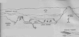
In July of 1769, a Spanish mule train lead by Franciscan Padres carrying 96 bars of silver was headed East from a location near present day Flagstaff toward their headquarter mission Santa Fe, NM. The mule train was attacked by Indians in the foot hills San Francisco Mountains, which were known in those days as the Sierra St. Francis and also Sierra Azul. The heavily laden mules started dying, and the attacks continued. The attacks got worse and soldiers were killed. After a final attack in a place called Padre Canyon, the group decided to bury the bars, as the mules were mules were too weak to continue, and only ten persons remained alive. The group then split, five going East and five going West, in attempts to get away.

In 1902, police in Kansas City picked an aging vagrant named Jose Chavez. He was suffering from pneumonia and was taken to a local hospital charity ward. After the second day it was clear that he was on his deathbed. Chavez called out to his nurse and handed her a vellum. He told her that this was a map to a great treasure of bars hidden in Arizona. Chavez passed away. The nurse did nothing with the document until she showed it to a doctor on staff at the hospital. The map eventually wound up in the possession of George McCormick, of Flagstaff. He had carefully translated the text which told the story of the attacks that took place from July 12 through July 19. The map and text were written by a soldier named D. Silva, one of the survivors that headed West to draw the Indians away from the two Padres and three remaining soldiers that had headed East.

Jose Chavez was well know around Albuquerque and was thought to be over 90 years old. He had been employed at the Mission in Santa Fe restoring leather bound books. There is a possibility that Chavez took the document from one of the books on which he worked.

In 1909 McCormick went to Flagstaff. He wanted to find someone that was familiar with the country, and contacted a Civil War Veteran by the name of Ben Doney. Doney provided guide service in the area. Sometime about 1910, a cowman by the name of Jack Diamond talked to a sheepherder that ran his herd in the meadows East of O'Leary Peak. He had found a bar that he thought was made out of iron. It was about 4" by 4", and about 23" long. It was found near the Eagle Rock Nest in Bonito Park. Diamond scratched the surface of the bar with his knife, and determined that the bar was silver. It apparently was one that was lost on the mule trains travel East.

The bar was sold to Alf's Dickinson's Pine Hotel on Santa Fe Avenue, and was on display for many years.

George McCormick and his Son looked for the bars for many years. Ben Doney never gave up either. He spent the rest of his life looking for the bars.

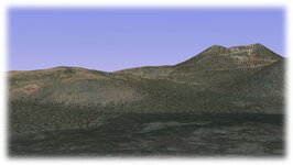
The red spot on the side of the mountain clearly identifies the East side of O'Leary Peak, and can be viewed using Google Earth.
 

Attachments

  • PadreSilver001.jpg
    PadreSilver001.jpg
    26.2 KB · Views: 1,093
Last edited:
OP
OP
L

lgadbois

Sr. Member
Mar 20, 2003
299
253
Now, I have some questions:

From where did the silver bars come? Were they mined in the Santa Cruz Valley? Was the silver mined North of Flagstaff? Is this the Treasury from some of the Missions that were closed at the arrest of the Jesuits in 1767? Some have speculated that the silver came from mines in Utah, or even from Colorado.

The trail East to Santa Fe from the San Francisco Mountains was very rough, in the heart of Indian lands, and went through Diablo Canyon. The main East/West trails were up North or much farther South. Was the group unknowledgeable about this country? Were these escaping Jesuit Padres?
 

lastleg

Silver Member
Feb 3, 2008
2,876
658
Anything is possible but the story sounds made up to me. Who knows what Kildare added to make
this legend feasible? I would check with Flagstaff historic society to see if that city claims a mission
was there in that period and if any legends are associated with it.

lastleg
 

OP
OP
L

lgadbois

Sr. Member
Mar 20, 2003
299
253
Another telling of the story:

"The chronicle of a Spanish party in 1769 is more definite. Recently this date was found by Melvin McCormick, cut with an inscription and a Christian cross into a huge rock on the Little Colorado River.This party, composed of several padres and Spanish soldiers was an ill-fated one. The Franciscans, having mined and collected a huge store of silver bars somewhere in central Arizona, set out to transport the treasure by mule train to their church headquarters in Santa Fe. In 1767 the Spanish crown had laid claim to all gold and silver found in the New World. The Franciscans had also been ordered from their New Mexico missions.
Coming up over the Mogollon Rim on the Navajo Trail, the train was attacked by an unknown tribe. Constant hit and run assaults forced the party west and north. They came in against Canyon Diablo somewhere around Two Guns. Standing off the Indians, the Spaniards followed downstream to where a crossing could be made.
According to a document and a map which came to light in 1902, the Spaniards were continually compelled to dispose of some of the weight overburdening the pack animals. Mules packing the silver were killed or gave out completely. The train gained part way along the side of Padre Canyon, which was so named for the fathers. Finally, against the Little Colorado, fatalities from Indian attack cut them down. As a final resort the many mule loads of silver bars were cached on the site of an abandoned Indian village.
The survivors split apart, five attempting to escape west into California, and another five east towards New Mexico. Apparently only the latter group made it through to their destination. For it was in the musty archives of the Old San Miguel mission in Santa Fe that the above-mentioned document was found.
The map locating the buried silver, and the account, brought many treasure hunters into the area. On one side of Padre Canyon, 18th century armor was recovered in 1919. One silver bar, approximately four inches square, about twenty-three long and weighing 64 pounds, was found by a sheepherder. The discovery was made west of Two Guns in Bonito Park, and is believed to have been lost from a pack mule before the cache was made."

Quoted from:
http://www.hkhinc.com/arizona/twoguns/history.htm


Crow

Silver Member
Jan 28, 2005
3,317
9,259
In a tax haven some where
Detector(s) used
ONES THAT GO BEEP! :-)
Primary Interest:
Other
Hello lgadois

Interesting treasure legend you posted.

I would not write the story off either as fake yarn or a real story just yet. However clearly the story has have verbal inaccuracies put into from various retelling of the story. That is of course the nature of such treasure legends. One good thing you have several names to work with.

For example you George and Melvin McCormick from Flagstaff Arizona? in the 1910 census there is father and son by the name of George and Melvin McCormick. see below

George and Melvin mc cormack 1910 census S.jpg

The only Jose Chavez I found was a widow in the 1900 Census living with his 45 year son and family in new Mexico. This Jose Chavez was Born in 1810 and did not appear anywhere in the 1910 Census. He would of been 90 in 1900, So we could assume he died some time between 1900 and 1910. The story said this Jose Chavez died in Kansas in 1902? I have not had access to the records of Kansas to confirm this. One question springs to mind why did he not pass the information onto his son or Grandson?

In earlier Census Jose Chavez was listed as a farmer. So we have no confirmation if he involved himself in book binding. I must add that not to say he wasn't we just have no record of that at this stage. I also like much to add all the Jose Chavez listed was recorded in New Mexico.

As for story claiming Sometime about 1910, a cowman by the name of Jack Diamond talked to a sheepherder that ran his herd in the meadows East of O'Leary Peak. He had found a bar that he thought was made out of iron. It was about 4" by 4", and about 23" long. It was found near the Eagle Rock Nest in Bonito Park. Diamond scratched the surface of the bar with his knife, and determined that the bar was silver.

Jack Diamond was listed in the 1920 census record as a railroad worker that lived in Colorado. Its perhaps not beyond the realms of impossibility he met some Sheepherder while working on the railway lines?

As for Alfred Dickinson I could not confirm the existence of the Pine hotel or him in Santa Fe in 1910?

As for Ben Doney he existed he was listed as a farmer and lived in Flagstaff Arizona. he was born in 1843 and died in 1933 aged 90. His date of death is listed on Find a grave. See his name mentioned in 1910 census.

Ben Doney 1910 census Flag staff Arizonia s.jpg

I managed to find out a little more about him.

So you see there is enough meat on the bone to chew over...

Crow
 

OP
OP
L

lgadbois

Sr. Member
Mar 20, 2003
299
253
Pine.jpg

Here is a picture of the Pine Hotel in Flagstaff from 1910. The hotel was located on Santa Fe Avenue near the train station. It was still in operation in 1924.
 

Crow

Silver Member
Jan 28, 2005
3,317
9,259
In a tax haven some where
Detector(s) used
ONES THAT GO BEEP! :-)
Primary Interest:
Other
Hello lgadois

Dol:BangHead:...The hotel was in flagstaff. I mixed it up and thought it was in Santa Fe

Here is more pictures of Ben Doney . And I can confirm that he was in the Civil war.

BEN DONY PORTRAIT.jpg

BEN FRANKIN DONEY.jpg

BEN DONY ON HIS PROPERTY.jpg

BEN DONY CABIN ARIZONIA.jpg

BEN DONEY UNION SOLDIER IN CIVIL WAR PENSION RECORD.jpg

BEN DONEY CABIN.jpg

There might be a possibility that his descendant have extra info on the story?

Anyway I hope its been of some help. Definitely worth you pursuing further.

Crow
 

OP
OP
L

lgadbois

Sr. Member
Mar 20, 2003
299
253
Ben Doney spent the rest of his life searching for the silver bars. Here is a recent article in the Arizona Daily Sun. Contrary to the suggestion that Doney may have found the bars in the article, he did not display sudden wealth or prosperity during his lifetime.

http://azdailysun.com/news/opinion/...cle_3ff70530-7da2-5e94-a41c-103f7a7152a8.html

At some point in time, Alf Dickinson sold the Pine Hotel to the owner of the Museum Club. He also sold the 64 pound silver bar. Alf and his son, Walt, were involved in mining. They may have been investors in the Oatman Amalgamated Gold Mine. .

George McCormick was a well know cattle rancher in Central Arizona, and was very politically active. Yes, there is a good possibility that Jack Diamond worked for the railroad.

Of course, in 1769 there was no town of Flagstaff or any nearby mission. There was no major trail running past the San Francisco Mountains. Local Indian tribes had banded together to drive the foreigners out of their land. Any Spanish, French, or other exploration party was in danger of being attacked. Spanish artifacts from that time period have been found in Chavez Pass and Diablo Canyon. Indian mounted major offensives against the Spanish in 1751, and again in 1771. Three things contributed to the building of the town of Flagstaff. Gold was discovered in the San Francisco Mountains, the railroad came, and U.S. 66 highway became the main street through town (Santa Fe Ave).
 

Crow

Silver Member
Jan 28, 2005
3,317
9,259
In a tax haven some where
Detector(s) used
ONES THAT GO BEEP! :-)
Primary Interest:
Other
Hello Lgadbois

Here is a1900 Census record showing Jose Chavez living with his son and Sons family he was list as 89 at the time.

Jose Chaves 1900 cenus New mexico s.jpg

The following picture may be actually of Jose Chavez however we er on the side of caution as it has yet to be confirmed. As there was several Jose Chavez with several birth dates. I am waiting to confirm the date of photograph.

Jose chaves.jpg

If anything it appears they major players in story existed. So perhaps there is further promise in digging deeper into the legend?

Anyway I hope this has been of help. Once again thanks again for sharing an interesting treasure legend.

Crow.
 

Crow

Silver Member
Jan 28, 2005
3,317
9,259
In a tax haven some where
Detector(s) used
ONES THAT GO BEEP! :-)
Primary Interest:
Other
Hello Lgadbois

Lastleg has made an excellent suggestion perhaps visit to the Flagstaff museam may uncover extra clues?

Crow
 

OP
OP
L

lgadbois

Sr. Member
Mar 20, 2003
299
253
This is a view of eastern slopes of O'Leary Peak from a location near Bonito Park.
 

Attachments

  • O'Leary2.jpg
    O'Leary2.jpg
    75.9 KB · Views: 491
Aug 23, 2013
468
1,426
Primary Interest:
All Treasure Hunting
Hello lgadbois and Crow

I have been really enjoying these posts. Please do keep posting....

Some interesting research here.

Corp
 

OP
OP
L

lgadbois

Sr. Member
Mar 20, 2003
299
253
Ben Doney was a veteran of the Civil War. He came to the Flagstaff area in 1882 with the announcement of the building of the Atlantic and Pacific Railroad. His plan was to homestead in the area, and to build a sawmill to supply the ties for the laying of the track. Doney was a loner. He was an avid prospector, and a digger of native artifacts. He is well known for his digging of Wupatki and had a collection of items that he later sold. Doney became a local guide for archeologists after private digging became illegal.

Doney was hired to try and locate the burial site of the silver bars by Chavez's nurse, a doctor, and the professor that translated the Spanish writing on the map. They did not want to show Doney the map because of an apparent lack of trust. Doney was interested, as he was seeking the location of a Lost Padre Mine. The Spanish had reported the finding of a rich mercury mine that was located 40 miles west of the Hopi villages in a red hill near the base of a blue mountain. Doney was convinced that the red mountain was the Wupatki area.

Doney filed many mining claims and even sunk a shaft through the floor of a pit house on the side of Doney Mountain. Navaho Indians used to collect eagle feathers from Doney Mountain, which was known to them as Red Mountain. Doney spent whatever time he had available searching for the mine and for the silver bars. There is no record of any mercury mine or the silver bars being found.

Ben Doney and his friends were involved in a scandal in 1908. They got themselves elected to the Flagstaff City Council and proceeded to eliminate the laws that prohibited vice and gambling. The good citizens of Flagstaff were eager to vote the rascals out of office at the next election.
 

Last edited:
Aug 23, 2013
468
1,426
Primary Interest:
All Treasure Hunting
Some interesting stuff.

There is possibility Doney was looking in wrong area? Doney perhaps was trying to connect the lost mine he was searching for with the buried silver shipment?

And a few others things might clarify the story to help understand the story better.

The mission of San Miguel in Santa Fe was not Jesuit but Franciscan Fray Alonso de Benavides was involved in its construction in 1610. Its mane was Nuestra Señora de Perpetuo Socorro. In 1680 the mission was destroyed by an Indian uprising with 80 parishioners dying in the walls of church after it was set fire to. 1n 1691 the are was recaptured and Indians subdued and in around 1710 church was rebuilt from the ruins. It served for a time as a chapel for the Spanish soldiers. The wooden reredos, which includes a wooden statue of Saint Michael dating back to at least 1709, was added in 1798. There was no Franciscans friars in New Mexico by the 1840's. However the mission was administered by the Franciscan church in Durango Mexico up until about 1819.

This was around the time of independence of Mexico from Spain. it is possible that church elders in Durango thought it safer to send a mule train of silver to their mission in Santa Fe?

Corp
 

Attachments

  • The_San_Miguel_chapel,_by_Brown,_William_Henry,_1928- s.jpg
    The_San_Miguel_chapel,_by_Brown,_William_Henry,_1928- s.jpg
    226.9 KB · Views: 359
OP
OP
L

lgadbois

Sr. Member
Mar 20, 2003
299
253
All sorts of possibilities exist. In 1769, I doubt if there were Franciscan Padres in Durango shipping silver bars by the route this mule train took. The Jesuits were arrested and deported in 1767. The trail north through Sonora and Pimeria Alta from Durango to Santa Fe?

The southern route east would have been much safer. The route past the San Francisco mountains and through Diablo Canyon was rugged, and by far the most dangerous. If the group had come from the north, the well traveled trail east along the Colorado River would have been a better choice. The Franciscan's territory extended north from the Gila river but from where would they have come? Some have suggested a mining operation in Sycamore Canyon might have been the source of the silver. At a later date a trade route between Santa Fe and California used this trail.

It might also be true that some of the Jesuits escaped arrest by heading north into hostile territory in attempts to save some of the church treasury. It must be remembered that Kino's maps of Pimeria Alta were being used at the time, but there was virtually no maps of the country north of the Gila River.
 

OP
OP
L

lgadbois

Sr. Member
Mar 20, 2003
299
253
It is tempting to believe that the silver bars were cached in Bonito Park, near where the first bar was found. I think the bars were cached farther east, perhaps in Padre Canyon. The diary entries by D. Silva suggest that the bars were buried, and the remaining group of ten split. Five headed east toward Santa Fe while the other five headed west in attempts to divert the attackers.
 

Aug 23, 2013
468
1,426
Primary Interest:
All Treasure Hunting
Hello Igadbois

If I was to guess and that would be only an assumption based on the reliability of the alleged map. I tend to think further south east.

This old cedar Tree might be one illustrated in the Map? However that is guess as there could be many old trees that fit the bill so to speak?

Corp
 

Attachments

  • OLD CEDAR TREE.jpg
    OLD CEDAR TREE.jpg
    167.2 KB · Views: 276
OP
OP
L

lgadbois

Sr. Member
Mar 20, 2003
299
253
C.I., you have a good eye!

The tree on the map is out of place. A person standing where they could see the view depicted in the map would be unable to see one solitary tree on hills in the background. There are many trees surrounding Bonito Park, but as you head east the land is dry. How long would a tree live out near Padre Canyon? Not long unless it was near a river or creek. In order to be a land mark, it would have to be a tree by itself like the one in your photo.

The view of the ledge between O'Leary Peak and Sunset Crater is the key. I assume that the round circles indicate boulders. Are the bars buried near a tree just below a canyon wall? The remaining ten survivors didn't have much time to find a place to cache them. The map indicates an "X" at the bottom of a diagonal break in the ledge. Perhaps a tree was used to line up with the break and the cache site. The place may have been selected as a good defensive position. Spanish armor and other artifacts were found in Diablo Canyon. They could have been from this party or some other. Maybe the mule train made it well into Diablo before the final attack.
 

OP
OP
L

lgadbois

Sr. Member
Mar 20, 2003
299
253
Another thought about the map:
The view appears to be looking west from a point south east of O'Leary Peak. If Sierra Azul is the San Francisco Mountains and the flat topped hill marked with the "S" is Sunset Crater, that seems to make sense. For some reason, Doney thought that the map view might actually be looking north, and the map was drawn that way to make it easy to identify major landmarks. It is also possible that the map is a mirror image and is actually looking to the east. None of the seekers has been able to find a site that looks like the ledge.
 

Top Member Reactions

Users who are viewing this thread

Top