Lue Map

Barton

Sr. Member
Apr 21, 2005
446
320
Abiquiu, NM
Detector(s) used
What ever is needed for the project I am working on--I am a cache hunter
Primary Interest:
Cache Hunting
Hello Randy Bradford,

Didn't we talk earlier? I am always up for lunch, especially if your buying.

KVM--was a man of dignity, honor and integrity. I knew him personally, visited him often, traveling up with Montana Larry Campbell. I've eaten with the man, ( and his wife --Gladus ) and used his research library. He kept my mail for me when he ran Examino in Segundo, Colorado.

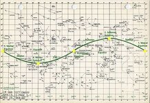
If KVM was alive; I think he would tell you that the biggest mistake he ever made--concerned the LUE map and publishing the photo of the gold bars--the gold bars in the cave--going back as far as the camera was capable of showing in the picture.

Because of that photo--he got threats on his life, his wife's life and his son's life--it is why his business was torched ( and burned to the ground ) by the same men who lacked dignity, honor and integrity. KVM had no patience for lazy individuals nor individuals who lacked honor and integrity. Sometimes VULTURES HAVE WINGS; SOMETIMES VULTURES HAVE TWO LEGS.

I would love to hear your presentation on the Lue at Orem but I do not get up there often--any chance I can hear it on a CD?
Dan--( Dan Wilde ) who started this post years ago--had a line on the LUE-- he wanted to view the original map--and had planned on doing so
unfortunately he passed away before he got a chance to do so. Dan was an outstanding researcher.

KVM KNEW the LUE Map WAS AUTHENTIC. If you read some of the stories--about Arnold Kojadern ( please excuse my spelling of the name )
---if one were to read between the lines--you could not tell stories about him--unless you too were there--witnessing the events. As a simple analogy
I have written many stories about a teenage Indian girl called Dancing Wind--either I have a vivid imagination--or possibly though I am not in the stories
about her--possible I tagged along with Dan the Lakota Medicine man and Dancing Wind.

If the LUE never existed--how do you explain the photo of the cave of gold bars, the photo of Larry and ( I forget who ) sighting over the sight stones--at the Cave of Gold of the Rio Grande--and how do you explain KVM sales of gold and silver. It sure was not the cave shown in the book " Treasure of the Valley of the Secrets " --where KVM
was getting his gold--If you don't believe me just ask Montana Larry.
 

sdcfia

Silver Member
Sep 28, 2014
3,650
8,867
Primary Interest:
Other
That seems a little personal there sdcfia. We have a difference of opinion and I not only invite but encourage your feedback. Frankly, I'm not as blind as you seem to imply...I fully recognize what your saying and have thought many of the same things myself. I still pursue what I do based on the evidence available. Frankly, I don't think the LUE is "worked to death," though I freely admit it still poses some significant challenges even if no recovery is made. As I see it, and I think we agree on this point, most every shred of evidence either comes straight from Von Mueller, or was published on behalf of others by Von Mueller. That poses some concerns and makes all available material something to be approached with some level of skepticism. Ultimately though, the people trying to prove the LUE a fraud have nothing but speculation and their evidence holds up to scrutiny only as well as Von Mueller's.

My only crime is not being a complete skeptic and approaching the data with the idea in mind that it may be true, and not the preconceived notion that it is not and cannot. Supporters and opponents of this topic both rely on faith ultimately. The only difference is I try to embrace the points of skepticism as aspects of study and consideration. I also recognize that I don't know everything and I try to keep an open mind and an open chain of thought to a lot of possibilities, particularly those provided by individuals who might have experiences, relationships and information that I do not. The simple fact is sdcfia, I recognize your perceptions and beliefs are shaped by a variety of aspects I'm not privy to. I not only accept that, I respect it, I value it and frankly I think you bring a lot more to the table then you either realize or let on. Just don't be so hard on folks that don't dismiss all of this out of hand.

At the end of the day, if I'm dead wrong what's the harm? We're all here to have an open dialogue and hopefully can do so in a thoughtful, mature, respectful and stimulating fashion. Thanks for the feedback and please don't be silent...just don't be so hard on us starry eyed dreamers. :)

Geez, relax Randy, I'm not judging you or anyone else - I'm merely saying that you've got a tough job trying to pin down the LUE, that's all. It's just not a topic I've had the time to pursue. I looked at it several years ago and couldn't gain any traction, so I moved on to other things. I certainly wouldn't call the LUE a fraud - I just don't understand what it is or what KVM's motivation was. There's lots of stories like this - you have to pick the ones that feel right.

I'm certainly not a complete skeptic and probably more starry-eyed than you might guess. That said, I don't have any trouble challenging claims that I don't agree with either, or offering my current views on things - views that constantly change when new evidence surfaces. If the truth were known about these things, we wouldn't even be talking about them. Good luck with your efforts - I hope you can eventually explain the whole thing to us.
 

Barton

Sr. Member
Apr 21, 2005
446
320
Abiquiu, NM
Detector(s) used
What ever is needed for the project I am working on--I am a cache hunter
Primary Interest:
Cache Hunting
Hello SDCFIA,

What do your initials stand for?

You wrote:That's an interesting thought. If there are indeed accurate longitudinal references on the "map", then it couldn't have been created before ca 1800 at the earliest, and if so, likely by a celestial navigator with an accurate chronometer (mariner?). If the "map" represents the New Mexico/Colorado region, then it may be more likely that it was created after the telegraph was established there - during or after the Civil War. In any case, this theory pretty much rules out the "Spanish" as creators of the "map" - but not necessarily as the exploiters of the "treasure", whatever it is.

I have a hard time following your logic: Are you saying--"If there are longitudinal references on the map, then it could not have been created before ca 1800"
I just have a hard time following your logic---for example if one went into the Spanish Archives--are you saying every map document is a forgery which is dated
prior to ca 1800 --if the map contains latitude and longitude references on the map???

I am willing to bet--using sun rise--and a calender a reasonable and competent person at Veracruz, Mexico ( a major Spanish seaport )--could plot or locate the same identical longitude and higher latitudes ( I am saying further North--ie el Paso, Santa Fe, or Eagles Nest--)simply using a calender and checking sunrise 365 days later
Remember back in the Spanish empire days it took approximately a year to travel from Veracruz, Mexico to Santa Fe, NM.

Now if the map were in fact JESUIT--those individuals were smart--they would have the ability to make the codes, to navigate and make maps.
I can tell you--in my opinion even today if your tracking a Jesuit trail--from the 1600-1700's you better be mighty XXX carefully or it will be the last trail
you ever track. They may have complied with the letter of the law of the king of Spain but they sure did not comply with the spirit of the law.
In my opinion if your tracking a jesuit--you can not simply track them like you would track a centuries old Spanish trail--as it will get you killed!!
They twisted everything just slightly! For example if a Spainard used a knife or sword to point towards a cache site--you can bet your life--if a Jesuit
put the knife or sword there for you to follow--it will lead to a bad outcome when you find the clearly marked dig site you cleverly figure out.
When you enter the tunnel--if it is Jesuit--you better figure you just entered the most dangerous place on the face of the earth--so even if you see
your gold bars or treasure chest right in front of you--you better not be counting your chickens before they hatch or making your airplane reservations to Paris

Now because of your first fact--this alone... " rules out the Spanish as the creators of the map...."

When KVM was selling silver--in his own words he said it came from Spanish silver bars.
When KVM was selling gold--and advertising he would sell it from one ounce to ten thousand ounce lots--( if I recall correctly )
He wanted $ 4 an ounce for silver and $ 60 an ounce for gold.

Is it possible his source of gold and silver was in fact the LUE??
 

sdcfia

Silver Member
Sep 28, 2014
3,650
8,867
Primary Interest:
Other
<cut>
I have a hard time following your logic: Are you saying--"If there are longitudinal references on the map, then it could not have been created before ca 1800"
I just have a hard time following your logic---for example if one went into the Spanish Archives--are you saying every map document is a forgery which is dated
prior to ca 1800 --if the map contains latitude and longitude references on the map???

I am willing to bet--using sun rise--and a calender a reasonable and competent person at Veracruz, Mexico ( a major Spanish seaport )--could plot or locate the same identical longitude and higher latitudes ( I am saying further North--ie el Paso, Santa Fe, or Eagles Nest--)simply using a calender and checking sunrise 365 days later
Remember back in the Spanish empire days it took approximately a year to travel from Veracruz, Mexico to Santa Fe, NM.

I would take that bet. You can't determine longitude with any degree of accuracy without a precision timepiece. The British developed one in the late 1700s and it completely changed celestial navigation, making the determination of longitude acceptably accurate. Latitude had always been accurately determined before then. Before the mariner's chronometer, longitude was only estimated using timing of eclipses, etc., which was totally unreliable. Even Columbus was very fortunate if he estimated longitude +/_ a couple hundred miles at sea.

On the same day every year, the sun rises at the same N-S angle at all points on a given latitude, no matter what the longitude is where you observe it. That angle changes when the latitude changes - it increases as you move south. Longitudes for sunrise change by time - as the longitude increases, so does the time difference as measured from Greenwich, England (0 deg long). Latitudes can be calculated easily by celestial observation, but longitudes require an accurate clock calibrated to Greenwich time. For example, if you are observing sunrise at 35 deg N, and your time measurement is off by twenty minutes from exact, you have made a 280 mile error - about 5 degrees of longitude. Due to the elevation above sea level in NM/CO, and the difficulty establishing a horizon in mountainous terrain, I would venture to guess that even if a land expedition possessed a mariner's chronometer and was able to carry it undamaged through MX and NM, they'd be lucky to measure longitude to within 20 miles. Just my opinion of course.

However, with the advent of the telegraph, the game changed. Surveyors were able to get split-second time signals from known positions and calculate their positions very accurately. If what you say about the LUE map is true - accurate lat/longs were used - then I'd say the map wasn't put together until after the Civil War, or later, when the use of the telegraph became common in NM/CO. If, of course, there are lat/long references on the map.


Now if the map were in fact JESUIT--those individuals were smart--they would have the ability to make the codes, to navigate and make maps.
<cut>
Is it possible his source of gold and silver was in fact the LUE??

I think it's quite possible the Jesuits may in some way be connected to the LUE map (if the map is genuine, of course), but in modern times, not prior to their 1767 expulsion from the New World.

As far as KVM is concerned, I have no way of knowing if he had any gold and silver.
 

Last edited:

Crow

Silver Member
Jan 28, 2005
3,317
9,259
In a tax haven some where
Detector(s) used
ONES THAT GO BEEP! :-)
Primary Interest:
Other
Hello just for an old raggedy old beach bum tropical tramp in beach house on an island in Coral sea. Could some one enlighten me on the identity of this Hardrock Hammond and his role in the Lue?

Crow
 

Crow

Silver Member
Jan 28, 2005
3,317
9,259
In a tax haven some where
Detector(s) used
ONES THAT GO BEEP! :-)
Primary Interest:
Other
Hello just for an old raggedy old beach bum tropical tramp in beach house on an island in Coral sea. Could some one enlighten me on the identity of this Hardrock Hammond and his role in the Lue?

Crow

Just for this old bird to add. “Spanish Trail of Gold” by Robert O. Burch in 1935. was the alleged source of this Lue map brought to Karl Muller via Hardrock Hammond?

Strange we do not have a any record of this book being published? So even if this copy was just self published perhaps when can find the alleged author Robert O. Burch ?

I found three Robert O Burch in the archives in the 1930s and 1940's one was Born in 1920 and served in WW2 at the end of the war and died on the 8th of August, 1994. He had six sons and 3 daughters.

The other 2 Robert O Burch were born in 1912 about 1916 respectively.

The 1916 born in Maryland Robert O. Burch died 26th of April 1999. He was a navy war Veteran and he is buried in Kentucky.

The only other Robert O. Burch Born 1912 north Carolina would of been 23 in 1935.

They are the only three people I could find in the United States with that name.

However I may of found something else?

Crow
 

Last edited:

sdcfia

Silver Member
Sep 28, 2014
3,650
8,867
Primary Interest:
Other
Just for this old bird to add. “Spanish Trail of Gold” by Robert O. Burch in 1935. was the alleged source of this Lue map brought to Karl Muller via Hardrock Hammond?

Strange we do not have a any record of this book being published? So even if this copy was just self published perhaps when can find the alleged author Robert O. Burch ?

I found three Robert O Burch in the archives in the 1930s and 1940's one was Born in 1920 and served in WW2 at the end of the war and died on the 8th of August, 1994. He had six sons and 3 daughters.

The other 2 Robert O Burch were born in 1912 about 1916 respectively.

The 1916 born in Maryland Robert O. Burch died 26th of April 1999. He was a navy war Veteran and he is buried in Kentucky.

The only other Robert O. Burch Born 1912 north Carolina would of been 23 in 1935.

They are the only three people I could find in the United States with that name.

However I may of found something else?

Crow

Not much in the public records - a couple Albuquerque city directory entries for a Robert Burch (no middle initial) in the proper time period. As far as the book is concerned, here's the long and short of it:

https://www.bing.com/search?q=%E2%80%9CSpanish+Trail+of+Gold%E2%80%9D+burch&PC=U316&FORM=CHROMN
 

Randy Bradford

Sr. Member
Jun 27, 2004
496
869
Hello just for an old raggedy old beach bum tropical tramp in beach house on an island in Coral sea. Could some one enlighten me on the identity of this Hardrock Hammond and his role in the Lue?

Crow

The Phoenix bit is a new one to me. Of course there is the Hardrock Hammond Daughters of the Pioneers Museum in Utah (or something like that) tale on the forums, plus the words Llorro Urraca Enterarri (sp?). I believe that is actually in reference to the area around Blanca Peak, not Utah. Lloro and Enterarri are pretty much 'to cry' and 'to bury', IIRC. Uracca is the name of an aunt of King/Saint Louis of France, for whom the San Luis Valley is named. Uracca is also a creek on the NW flank of Blanca. On which there is the Urraca Pioneer cemetary, a Mormon cemetry. That is not too far north of Ft. Garland, referenced in ToVoS.

This was from an issue of the NPG as written by KVM himself:

The original map as copied and reproduced in the THM-7 was owned by a man who lived in or near Phoenix. The map had been in his family for years and has been seen by dozens of people prior to 1960. Despite this, there are several others who claim to have the original map in their possession.

Then you have what KvM wrote in Treasure of the Valley of Secrets:
and, although we had no idea whatsoever...Hardrock Hammond had come into possession of the LUE map and several of us were busy copying it (it had to be returned to the owner after we had copied it)...

I'm not sure where the Daughter of Utah Pioneers archives came to be associated with the LUE, though it's possible it seems unlikely. Besides contradicting what KvM wrote about it, the LUE has no known association with Utah. The only definitive reference to this comes form an article by Boyd Jolley that ran in Treasure magazine in 1991. He refers second hand to a letter written by KvM which indicates:(In Salt Lake City, Utah, in) the archives of the Daughters of the Utah Pioneers, (you should) finda journal that has several entries relating to the map and a rough sketch of the map. (However, you should also be aware that permission may not be granted to use these historically valuable materials.) There is also a possibility that the Utah State Historical Society might have copies of the journals and be familiar with the LUE map.

KvM did say the LUE was derived from the first three letters of three words that were on the map. So far as I know, I have never seen a first hand quote from him indicating what these words were. Jolley also refers here to an unpublished KvM letter when he indicates that KvM states: Parts of the original LUE story have appeared in several popular books but I am one who coined the word LUE from the firs three words (Lloro, Urraca and Enterrari) that were crudely scribbled on the original map.

Probably the most interesting thing to come of this is the presence of Urraca Mesa, which is in the vicinity of some of the alleged LUE cache recoveries:

data=t0xO2hhtZnTqjH9t1B9hV2qiKhImDYdQvYZBSFfnIZ8GaLCrke6-Bl0,PMcBG1l1xR2k_0NcmC8DlvxFE9Z2nB9FETkA_EJP5-prndOS7zvnvGZHWwEJrBFQgEPtb5yRJwOlrnapYafhvNmydjkbseSs


Randy Bradford

Sr. Member
Jun 27, 2004
496
869
Man ... Just as I'm being all dramatic and making my last 'official' post at TNet, a message box popped up saying I had a new PM. I finished the post and then read the PM. It was from someone commenting on my posts in this thread, which of course drew me back here in my process of wrapping things up here, and well, let me be a bit of a Drama Queen and make this post my last official post. Lol and for real. I'm sure a least one person reading will deem it appropriate for me to end my stay here on this subject.

There's a lot to be said for fortuitous timing. Honestly, when you said you were headed for the high country I about fell out of my chair, giving me your email was a real blessing and one I intend to exploit not long after I complete this post. I've nothing else, perhaps we've given yo ua reason to stick around a bit long. I certainly hope so. Your older contributions were solid and I've made efforts to re-involve a number of the former posters to this thread. At least one has passed on (the thread OP sadly enough) and several others have abandoned Tnet. For me the livlier and more content driven the conversation is and remains, the better...though certainly I have no control over that.

I'm not picking apart anyone's comments, but let me quote a few and share my thoughts on them.

Randy:

KvM has KGC ties. As in working with descendent information. My opinion, of course, and is not a comment upon his character. People that are direct descendents of some of these guys and have inside info just happen to be born into it. There will be the spectrum of personalities in these families, from scoundrels to saints. Now, do I have any solid evidence to show anyone on that? Nope. Do with that opinion what you will. Concerning people not being around to defend themselves, my take on all of that, including myself, is it comes with the territory and should be expected. Get involved with this stuff and play poker with information, well expect to have your motives and potential ulterior ones, etc., discussed, whether you are alive or dead, both in public and in private.

His travel history would not suggest this, though it's as good an answer as any without KvM here to explain. In a period of years KvM lived in Nebraska, California, Utah and Colorado (that I know of, perhaps other places as well). He actually wrote a lengthy article about why he moved to Segundo, CO and there was much suggestion he went there to pursue the Treasure of the Valley of Secrets. I've often wondered if the LUE has a KGC connection but have been unsure. I think it remains one of the top 3 possibilities. the KGC as a large treasure source so far as I know was unknown until "Jesse James was one of his Names" was published in 1975. I don't think KvM published much about the topic, and certainly wasn't publishing about it from 1966 to 1972 which is when he published the bulk of the material on the LUE.

I also suspect that VIP club in Cali referenced in ToVoS was a group of descendents that would get together and share info/play poker with info to either get help on their own sites or share info about potential other ones. Sumpin' about SoCali smells like some kind of KGC 'retirement home' to me, among other places.

Again, I suppose it's possible. Von Mueller himself states he was a member in the mid 1950s of the Valley Independent Petrologists. I suppose one has to wonder, if it's all a clandestine KGC event why write about it at all, much less write about it in a way that easily exposes the possibility of clandestine activity.

I also saw a claim I have not verified of someone triggering a bobby trap in the Sangres and killing one or more THers around the time KvM first mentions hearing of the Cave 'O Gold. Way unverified claim on that, but I know of it.

I don't know about a booby trap kill, KvM wrote in the NPG at length about people being assaulted, threatened and even shot at while searching the LUE. this is a common trope with major treasure though, the same is often said of people hunting the Lost Dutchman and the Lost Rhoades Mines for instance.

Randy
 

Randy Bradford

Sr. Member
Jun 27, 2004
496
869
Now if the map were in fact JESUIT--those individuals were smart--they would have the ability to make the codes, to navigate and make maps.
I can tell you--in my opinion even today if your tracking a Jesuit trail--from the 1600-1700's you better be mighty XXX carefully or it will be the last trail
you ever track. They may have complied with the letter of the law of the king of Spain but they sure did not comply with the spirit of the law.
In my opinion if your tracking a jesuit--you can not simply track them like you would track a centuries old Spanish trail--as it will get you killed!!
They twisted everything just slightly! For example if a Spainard used a knife or sword to point towards a cache site--you can bet your life--if a Jesuit
put the knife or sword there for you to follow--it will lead to a bad outcome when you find the clearly marked dig site you cleverly figure out.
When you enter the tunnel--if it is Jesuit--you better figure you just entered the most dangerous place on the face of the earth--so even if you see
your gold bars or treasure chest right in front of you--you better not be counting your chickens before they hatch or making your airplane reservations to Paris
Is it possible his source of gold and silver was in fact the LUE??

I've often wondered if the LUE gold wasn't sourced by the Spaniards but that the LUE map was designed and created by either the Jesuits or the Franciscans. My knowledge of both these groups is sorely lacking, but it seemed to me that a relationship between the mining and the hiding makes sense. That the Spanish were the origins of the gold seemed conclusive to KvM. He spoke a great deal of mining activity in the Segundo region, in particular placer mines and a large Spanish camping area that he described but is likely been long since explored and destroyed. That region has been described as a significant area for Spanish mining by a number of authors, the one that immediately comes to mind is Perry Eberhart.

Randy
 

Randy Bradford

Sr. Member
Jun 27, 2004
496
869
Just for this old bird to add. “Spanish Trail of Gold” by Robert O. Burch in 1935. was the alleged source of this Lue map brought to Karl Muller via Hardrock Hammond?

Strange we do not have a any record of this book being published? So even if this copy was just self published perhaps when can find the alleged author Robert O. Burch ?

Crow

Not as strange as you might think. For one thing I've heard the Burch piece frequently referred to as a pamphlet and not a book, per se. It's possible it was published but not widely carried because it was a pamphlet and not a book, just a thought. Also, I don't know what self-publishing was like in the 1930s, but it's very possible it had a very small print run and may not have been picked up by libraries...would depend a lot on how the book was marketed. My sense is it was a very small run though who really knows.

I've never head of this title being the source of KvM's LUE map that he later published. It's possible that the Phoenix map was in fact one in the same, but without a statement by KvM indicating it was the source at this point it remains speculation, though this is true of much of the LUE.
 

RW

Hero Member
Feb 7, 2007
922
993
Fort Worth'ish
Detector(s) used
Golden uMax w/CleanSweep - XP Deus
Primary Interest:
Cache Hunting
Every time I comb through #7 I always stare at the map for about 10 minutes. In those 10 minutes all kinds off correlations and assumptions pass through my mind and usually around minute 9 I can't think clear enough to even tie my shoe. This thread is a great read but my head is spinning.
 

Randy Bradford

Sr. Member
Jun 27, 2004
496
869
Every time I comb through #7 I always stare at the map for about 10 minutes. In those 10 minutes all kinds off correlations and assumptions pass through my mind and usually around minute 9 I can't think clear enough to even tie my shoe. This thread is a great read but my head is spinning.

Don't be shy, share some of those correlations and assumptions!
 

RW

Hero Member
Feb 7, 2007
922
993
Fort Worth'ish
Detector(s) used
Golden uMax w/CleanSweep - XP Deus
Primary Interest:
Cache Hunting
There is too much perfect geometry to resemble anything in nature. The geometry are most likely measurements of distance or scale. If you only concentrate on the lines that are not straight, just the curved lines and circles, a topo map with 3 mountain tops and 2 rivers starts to show itself. But again, the 2 rivers are too geometric to be natural. The random lines that don't appear to be part of a larger image may have the most significance. All still total nonsense in my mind but I plan to redraw the map in Adobe Illustrator so than I can turn on and off layers to view the "map" with less confusion. Also, KVM's "exact copy" appears slightly different than the map that shows the symbols outside the "map". The shaded side of the pyramid that I took as a north marker isn't shaded either.
 

Last edited:

Randy Bradford

Sr. Member
Jun 27, 2004
496
869
There is too much perfect geometry to resemble anything in nature. The geometry are most likely measurements of distance or scale. If you only concentrate on the lines that are not straight, just the curved lines and circles, a topo map with 3 mountain tops and 2 rivers starts to show itself. But again, the 2 rivers are too geometric to be natural. The random lines that don't appear to be part of a larger image may have the most significance. All still total nonsense in my mind but I plan to redraw the map in Adobe Illustrator so than I can turn on and off layers to view the "map" with less confusion. Also, KVM's "exact copy" appears slightly different than the map that shows the symbols outside the "map". The shaded side of the pyramid that I took as a north marker isn't shaded either.

Well, to my mind everything in the map has a purpose, if you start with that in mind it becomes extremely complicated because features of the map could represent mathematical components, be symbolic, a combination of the two, or something else all together.

The Sine waves represent some interesting possibilities. One of the earliest things I've seen printed about the map was from a man who felt the lines represented the Colorado and Rio Grande Rivers. Dr. Roy Roush in one of his books about the KGC talks about the LUE and he drew comparisons of the map with star charts like this:

A11StarChart-S1-annotated-by-Jim-Johnson.jpg

Not sure how to resize in here, you can get a larger more clear example of the star chart at:
http://jrjohnson.net/wp-content/uploads/2015/03/A11StarChart-S1-annotated-by-Jim-Johnson.jpg


The geometry in my estimation suggest someone that is well educated in math or astronomy, perhaps both. Not sure how the Jesuits or Spanish fit into that picture. An argument could be made likewise for masons who might have some understanding of both the mechanics and the symbolism within the map. The pyramid and the eye are suggestive of this theory as well though I've often felt that was too obvious. The upper right corner of the map has a vertical and horizontal line that look similar to a sun sighting instrument that mariners would have used to take their position at sea with.

It's interesting you mention the other map with the symbols on the outer edge. I've always felt that was a fake, the symbols on the edge look far more crude and do not match the overall style of the map. The earliest mention I've heard of that version was about 15 years ago on this very forum. Thomas Hilton when he ran his article in the Feb 1970 issue of True Treasure also published a slightly modified version of the map, I suspect this was to avoid a lawsuit from KvM whom he infers in the article but never mentions by name or gives credit to KvM for publishing the map. Ironically, many researchers beleive the Hilton article to be the first article on the LUE. This is because many researchers did not check the treasure hunting tabloids that KvM was involved with, nor were they ware that the RAM version of Treasure Hunters Manual #7 was a reprint of the original 1966 Gold Bug version of the same book.
 

Attachments

  • A11StarChart-S1-annotated-by-Jim-Johnson Rezie.jpg
    A11StarChart-S1-annotated-by-Jim-Johnson Rezie.jpg
    58.6 KB · Views: 278

RW

Hero Member
Feb 7, 2007
922
993
Fort Worth'ish
Detector(s) used
Golden uMax w/CleanSweep - XP Deus
Primary Interest:
Cache Hunting
Thanks for all of the information. The star maps are way beyond my pea brain realm. I was leaning towards the sine wave being a divider, meaning it represented too large of a distance to shown in one map. Basically 2 maps in one but that kind of complicates the topo theory. I connected the gaps in the suns rays and came up with a "snaking" river. I rotated, inverted and overlayed the map in many combinations and the geometry really gets confusing. After generating a few possible topos I was trying to count the geometric numbers and angles to try and come up with a longitude/latitude that matched one of the topos. Also, rotating the map from the center, until the 2 sine waves overlap and rotating again until they overlap in the opposite location creates a path for the sun across the sky. If the shadow on the NW pyramid in a North pointer, it could help solidify any other theory that seems to match up. So many ifs... Studying the star maps now. Thanks again.
 

Last edited:

Randy Bradford

Sr. Member
Jun 27, 2004
496
869
Thanks for all of the information. The star maps are way beyond my pea brain realm. I was leaning towards the sine wave being a divider, meaning it represented too large of a distance to shown in one map. Basically 2 maps in one but that kind of complicates the topo theory. I connected the gaps in the suns rays and came up with a "snaking" river. I rotated, inverted and overlayed the map in many combinations and the geometry really gets confusing. After generating a few possible topos I was trying to count the geometric numbers and angles to try and come up with a longitude/latitude that matched one of the topos. Also, rotating the map from the center, until the 2 sine waves overlap and rotating again until they overlap in the opposite location creates a path for the sun across the sky. If the shadow on the NW pyramid in a North pointer, it could help solidify any other theory that seems to match up. So many ifs... Studying the star maps now. Thanks again.

The star maps are way beyond my brain as well...I only offered it because someone else thought it relevant (Dr. Roush) and the similarities with the use of the sine wave cannot be completely dismissed. Minimally it suggests additional evidence along with the cross bar in the upper right corner which was used to navigate with the sun. Refer to the Thomas Hood Cross Staff: Backstaff - Wikipedia, the free encyclopedia

One interesting thing about the sine wave is the tale on the left side, which is absent from the right. I've tried to "recreate" the missing part of the wave line, forgive my primitive skills at Paint.

LUE KvM THM7 Loop in Sine Wave.jpg
Not sure about two maps in one, though I've been told on more than one occasion that yo can divide the map into four quadrants and they each represent something different. I actually had someone send me a whole list of some of the geometric properties of the map. I'm going to ask them permission to post it.

Randy
 

sdcfia

Silver Member
Sep 28, 2014
3,650
8,867
Primary Interest:
Other
Sdcfia , your are throwing land calculation of Longitude in with ship calculation of it away from land. They are 2 different things. Land calculation was relatively easy, but on a ship it was not. Much of the United States was mapped out by the late 1500's with Latitude and Longitude. Also more specific maps of smaller regions even showed Magnetic declination of the area. Maps are out there, if you take a little time researching.

Any Cub Scout can determine magnetic declination for you - it constantly changes and is a moot point with the creation of permanent maps.

"Much of the United States was mapped out by the late 1500's with Latitude and Longitude." Oh, really? Please back up that statement, showing me maps from the 17th century (hell, make it the 19th) west of the Mississippi with specific longitudinal determinations closer than two degrees error.
 

sdcfia

Silver Member
Sep 28, 2014
3,650
8,867
Primary Interest:
Other
We have no idea what that LUE chart is. It could be an accurate surveyor's plat. It could be a symbolic map referring to certain landmarks. It could be part of a geologic fault chart for a specific geologic region. It could be a Fibonacci overlay. It could be a star chart overlay. It could be a topo map overlay. It could be an overlay to a thousand other specific reference maps or documents. It could be origami. It could be an early application of some sort of bar coding. It could be some sort of cipher reference to a text document. It could be a secret hidden technique giving specific coordinates. It could refer to a certain carved block on the Washington Monument, or the Giza Pyramid, or the Pyramid of the Sun. 90% of the lines and symbols on it may be meaningless and require eliminating. It could be any number of things, and you know what? It is either 1) a complete hoax; or, 2) the product of somebody who had proprietary knowledge of its construction and likewise required its later users to have that same knowledge. If it was just a damned map, it'd be duck soup to figure out. But it isn't - it's some other type of information system that was put together by someone a lot smarter than us who knew that an outsider would never figure it out. Unless it's a complete hoax, that is.

All we know about the LUE came through KVM. He got his information, including the map, ideas about Walter Hurt, alleged cache recoveries, etc. from others - "high powered treasure hunters". Why did they tell him? Who were these heavy hitters? I speculate that, like other major-league southwestern treasure legends of the same late 19th century through the 1930s era - Lost Dutchman, Lost Adams, Caballo Mountains, Victorio Peak, Arizona Jesuit Caches, et al - the LUE legend describes something of value hidden in its area, certain details of which have been coded into the popular stories. Yes ... a conspiracy. All of us gutter rats are out in the alley behind the restaurant scrambling for crumbs while the guys in the know are inside enjoying French pastries. We get excited when we find a nice piece of crust, but there's no sweetness to it. Is KVM inside the restaurant with his pals, or is he out in the alley with us? It doesn't matter.

The LUE, Treasure Mountain Gold, the Lost Gold Mine of Juan Mondragon stories, and others, all seem to be indicating the Sangre de Christo range, from Truchas Peak to Culebra Peak to Blanca Peak, and tell us there was a lot of gold hidden there. Europeans are prominent in those tales - Germans, Italians and French, or some claim it was all Spanish. Regardless, someone apparently found this gold before the Anglo invasion, hid it in the mountains, then told cryptic stories about it - the stories that have us running in endless circles today. These folks - whether KGC, OAK, Knights Templar, Masons, Merovingians, Jesuits, Mormons, any or all of them - must know the truth. They're the ones in the restaurant while we're the ones out in the alley.

Note to Nobody re the SoCal Club: Paso Robles would be a nice clubhouse location.
 

Top Member Reactions

Users who are viewing this thread

Latest Discussions

Top