Crow
Silver Member
- Jan 28, 2005
- 3,319
- 9,267
- Detector(s) used
- ONES THAT GO BEEP! :-)
- Primary Interest:
- Other
There may still be a descendant in Area I will PM you.
Crow
Crow
Well, I would post Google Earth Pro images to illustrate the trails, but for some reason T-net won't allow pdf's to be posted in threads.....
I can email them to you crow if you will shoot me your email in a pm, and also anyone else who wants them. The presence of these trails is either from a lot of game using them, or from a lot of hikers.


Sdcfia, are you seeing that trail on any official maps?
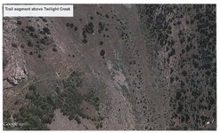
Here are images from Google Earth Pro
View attachment 1135376 View attachment 1135377
I put a thin yellow line next to the trails for illustration purposes.
I'm wondering if the ascent from Lime Creek along Twilight Creek is possible. I can't imagine anyone taking the long way around when it would involve climbing up another 800 feet and adding miles to the whole trip in some of the roughest country on the planet. Its easy to get fooled by GE maps with regard to this, and all it would take is a cliff of 30 feet or so to make it impassable trying to follow Twilight Creek.
Sdcfia, can you give me a URL to the mountaineer blogs you refer to above so perhaps I can contact people who have already been there and know first hand the terrain involved? I would appreciate it.
Sdcfia, can you give me a URL to the mountaineer blogs you refer to above so perhaps I can contact people who have already been there and know first hand the terrain involved? I would appreciate it.


.jpg")
.jpg")