trail markers?

hoagiem

Greenie
Jan 9, 2006
11
0
i am posting 2 pics but can't figure out how to get them in between the text so they will be at the end.

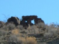
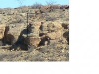
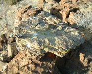
the first is a picture of what may be a compass rock but i am not sure. the pic is blurry but the story is like this. the top rock which is situated on three other rocks is different in composition then the support rocks. the top rock appears to have come from an area about 100 feet or so away from this formation. i tried to lift the top rock but it would not budge, maybe with four or five people maybe but it would be tough. the formation is situated up the hillside from a creekbed. i stood at the left side of the picture and looked across the rock along the point which seemed to point up the canyon it was in. the only structure i could see that resembled another marker was a ledge. i went to the ledge and stood on it trying to see another formation and when i looked back toward the "compass rock" i saw what appeared to be a face (second picture) the picture does not really resemble a face from the perspective which i took the picture but standing on the rock ledge it sure looked like a face. from the ledge it looked as though the face was looking right up the canyon. now, if it is a face could it mean that the persons following the trail should start looking for a trail marker? the canyon curves and winds quite a bit. from on top of the "compass rock" looking down the canyon there is a good distance you can see. i didn't study that direction as much as a should have but i will go back and look around some. any thoughts on what these could mean? the 1st picture is definately not a natural formation. how would i read a compass rock, if this is one, without one point being on the ground?

any help would be greatly appreciated.
 

Attachments

  • DSCF0092.JPG
    DSCF0092.JPG
    44.8 KB · Views: 825
  • rockface.JPG
    rockface.JPG
    29.7 KB · Views: 821
OP
OP
H

hoagiem

Greenie
Jan 9, 2006
11
0
i went back out to the site and found out some other info. the terrain looks completely different in the late afternoon and the initial items i saw were not visible when the sun is directly on them. morning to midday appears to be the best viewing, i will get more, and clearer pics soon. i placed a compass on what i am assuming to be a compass rock in line with two of the support rocks and it reads north/south. when facing north the third support is to the east and the rock is somewhat triangular shaped and appears to be pointing east. the formation is situated on the west side of a small hill. when i look east from the formation all i can see is hillside. looking south is the same. looking north is a hill off in the distance, i scanned the hillside with binoculars but couldn't really make out anything. looking west is a hilltop but over that is the base of the mountains. i went over the area again but could not find any writings or markings. again looking to the north and down the hill is an area that is bedrock, the odd part of this is there are several trees and stumps that grew up out of the bedrock. the area looks like it may have been a spring at one time. it is odd to see a large portion of exposed bedrock with trees coming up out of it. i will get some pictures when i get a chance.

any help on the compass rock would be appreciated.

the following pictures show the difference in materials of the rocks and one of the support rocks that appears to have been placed there to support the top rock and the top rock with a compass on it lined up with two of the supports.
 

Attachments

  • DSCF0004.JPG
    DSCF0004.JPG
    89.6 KB · Views: 778
  • top rock.JPG
    top rock.JPG
    77.8 KB · Views: 769
OP
OP
H

hoagiem

Greenie
Jan 9, 2006
11
0
i hope someone can help also,it has my curiosity way up. i went back out there today to satisfy a hunch i had. i went back up the canyon and stood below what i call the face rock. with the morning sun it is qute visible as a face. before i go on i forgot my camera, huge brainfart, left it laying on the table. anyway, i noticed a rock about 2' square sticking up out of the sand with some "carving" on it. the lines in it looked amazingly similar to the creek beds in this area, coincidence? maybe. there was a triangle carved at the intersection of two of the lines just like the intersection of the two creek beds on either side of the hill the "compass rock" was on. this little carved triangle was also pointing north.

the canyon goes north for a little bit and then turns northeast so i decided to follow the canyon up as far as i could go. up the canyon and around the bend i find a old foundation and four standing walls made out of adobe. looked around and found a lot of trash, metal detecting type trash. i continued up the canyon a ways and found a fireplace/indian oven looking thing made from flat rock. the thing was immaculate, most of the adobe mortar had washed out and there was no sign of soot so it had not been unused for quite a while. nothing showed in the fire area on my metal detector. the ground inside was very soft and i could easily dig in several inches.

further up the canyon i come across an area of several flat rock walls anywhere from barely visible to three feet tall. one was still alll four walls and the entrance was still in it, the walls were only three feet tall. several bushes around and one right in front of the doorway. the curious part of this area is there was an old riveted iron furnace/incinerator there. probably six foot diameter at the base and eight feet tall if it was reassembled. the building remnants are at several different elevations and all are at least 8-10 foot above the creek bed, just like the fireplace i came across earlier. i am not sure what type of furnace/incinerator apparatus was used for smelting but this could possibly be one? there was an opening about 18" x 24" with a large hook just above the opening.

i am still kicking myself for forgetting my camera.

there is nothing close to this area for several miles and access is limited to four wheel drive or horse. why would this large incinerator be way the heck out there? any guidance would be appreciated.

there is well documented spanish and indian activity in this area as well as mining gold, silver, lead and copper. there are not any mines in this area, close proximity anyway.

i'll try to get some pictures soon.
 

Monk

Sr. Member
Sep 10, 2004
270
19
Where ever my coffee cup lands
Detector(s) used
Fisher 1280X
hoagien!
Just a thought, but maybe you might look at a Topo Map of the area. It might just show what you have found? Plus go to the library and look at old maps and history of area. There may be something written that will behelpful.
 

OP
OP
H

hoagiem

Greenie
Jan 9, 2006
11
0
i will get some photos the next time i am there, i promise. i am about ten hours from the site right now and was planning to be there this weekend but couldn't get there. i have found some pictures of a water jacket smelter and it looks just like the one at the site. i am still trying to find out how they work so i can possibly locate a mine nearby. it seems that they were used to pump water out of a mine. i found an article in ghost towns of oklahoma about an old gold mine in oklahoma and the pictures showed a furnace/smelter identical to the one i saw. apparently they were processing ore of some kind there.

the pics wil be on here in a few weeks. life is that thing that gets in the way when you are trying to live. good luck to everybody.
 

gollum

Gold Member
Jan 2, 2006
6,729
7,596
Arizona Vagrant
Detector(s) used
Minelab SD2200D (Modded)/ Whites GMT 24k / Fisher FX-3 / Fisher Gold Bug II / Fisher Gemini / Schiebel MIMID / Falcon MD-20
Primary Interest:
All Treasure Hunting
If you look under the "Compass Rock" it looks like strengthened firing positions for a couple of people. Depends on what part of the country this is in. Could be Civil War or Indian Fighters depending on location.

If it were Spanish or Mexican, there would always be a fair sized "V" or "X" cut into the rock. The Hispanics ALWAYS did this so successive people would definately be able to tell the difference between Man-Made and Mother Nature. These V's and X's are always easy to spot from one side or the other.
 

Top Member Reactions

Users who are viewing this thread

Top