Drill hole in river bedrock

Blind.In.Texas

Bronze Member
Sep 1, 2006
1,696
29
Lone Star State
Primary Interest:
All Treasure Hunting
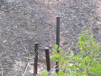
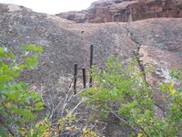
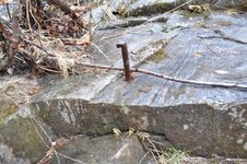
Can anyone think of plausible reasons why I would a perfect drill in the river bedrock and above the normal water line? The nearest road crossing is a low water bridge .5 miles up river. The next crossing is nearly two miles downriver. The drill hole is about 1" - 1 1/2" in diameter. When I get back there this summer I will get pictures. I should be going back in June. Thanks. If anyone else has river bedrock drill hole pictures, by all means post away.
drill%20hole%20-%20river.jpg
 

Old Dog

Gold Member
May 22, 2007
5,860
397
Western Colorado
Here is a couple from the Domiguez Canyon with the drills left in the last holes.
Our belief is that they were used as a ferry anchor.
 

Attachments

  • Drills in stone 2.jpg
    Drills in stone 2.jpg
    106.8 KB · Views: 525
  • DrillS in stone 1.jpg
    DrillS in stone 1.jpg
    114.8 KB · Views: 515
  • Drills in stone 2.jpg
    Drills in stone 2.jpg
    106.8 KB · Views: 458
  • DrillS in stone 1.jpg
    DrillS in stone 1.jpg
    114.8 KB · Views: 469

jayheazy

Jr. Member
Oct 13, 2007
43
0
I found this about a quarter mile up stream from my indian cheif carvings. There is an old mill (1700s) foundation not too far away as well, so it may be related to that.

The water is not deep enough for a boat to be anchored with it, so I really have no idea why its there.
 

Attachments

  • 066.JPG
    066.JPG
    186.7 KB · Views: 706

extractor

Silver Member
Sep 27, 2007
2,941
53
Sal Sagev Adaven
Detector(s) used
E-TRAC,,,, SOVEREIGN GT,,,, GP 3500,,,,
GB PRO.
Primary Interest:
Metal Detecting
Along the Colorodo river I have seen a lot of them . They were used as points to attach the winch lines of ferry boats in years past. Depending on the snow melt / storm water flow / rapids and laden weight of the boat , some times a winch line was used to help the trip up stream.
 

mamabear

Silver Member
Feb 21, 2008
3,071
869
SE Missouri
Detector(s) used
garage sale oldie
Primary Interest:
Other
we have some drill holes in rock at a local swimming hole. there was a t one time a grain mill there. all that is left is some holes in the granite. the water was never deep enough for any type of boat.
 

OP
OP
Blind.In.Texas

Blind.In.Texas

Bronze Member
Sep 1, 2006
1,696
29
Lone Star State
Primary Interest:
All Treasure Hunting
extractor said:
Along the Colorodo river I have seen a lot of them . They were used as points to attach the winch lines of ferry boats in years past. Depending on the snow melt / storm water flow / rapids and laden weight of the boat , some times a winch line was used to help the trip up stream.
I like that. As dsty mentioned once, it could have been for modern dredgers as an anchor point and could also fit extractor's view. Quite possibly it could have been used to wench small barges upstream/downstream which means that there should be other holes. I have at least four days every year when I go there. I will definitely be searching that whole stretch for more clues. Thanks for giving me the 'bug' fellas. Nothing could be too complicated at this point. The more scenarios or suggestions I have, the more creative I can be in my searches of unobscure locations.
 

Old Dog

Gold Member
May 22, 2007
5,860
397
Western Colorado
The ones I pictured above are on the Gunnison River.
If you attach a line to the bow of a boat just back from the prow.
at a gentle curve of the river depending on which side of the boat the line is attached ...
The current will do the work and send the boat from oneside to the other.
Swap sides with the line and the boat will come back.

Simple engineering.
The Spanish used it.
 

RockHopper2

Full Member
Nov 22, 2009
204
151
Fletcher, OK
Your right on DSTY. Sometimes I put to much into the signs and make it too hard to figure out. Thanks to you, Old dog and dign I'm beginning to think on the right path. Thannks guys. RH2
 

OP
OP
Blind.In.Texas

Blind.In.Texas

Bronze Member
Sep 1, 2006
1,696
29
Lone Star State
Primary Interest:
All Treasure Hunting
RockHopper2 said:
Your right on DSTY. Sometimes I put to much into the signs and make it too hard to figure out. Thanks to you, Old dog and dign I'm beginning to think on the right path. Thannks guys. RH2
I agree with and appreciate everyone's input. New things are often complicated to those of us who lack knowledge and experience of new ventures.

OldDog: I really wish I had known of such things when I discovered that three rock formation. The one I disturbed. However, with the help of GE and a lot of refreshing about the area, I have found three points of contact which closely resemble a reversal of the picture I took. I remembered that some signs are reversed. When I mirrored the image and placed it over the location, it seemed to make a nice geometric match. The two natural landmarks, represented by the small stones (after reversal), also pointed a line to the location where the formation was originally found, nearly 7,000 feet away. Of course, with such horrible resolution, in low traffic areas, exact distances with only happen with a wheel or GPS. Maybe all hope is not lost of finding anything. Now it may be a bit more difficult but, I don't believe impossible.
 

Top Member Reactions

Users who are viewing this thread

Top