Rock Arrangement - pictures

Blind.In.Texas

Bronze Member
Sep 1, 2006
1,696
29
Lone Star State
Primary Interest:
All Treasure Hunting
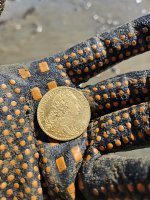
Ok. I posted this photo a while back and was told that since I had destroyed the scene, by removing the markers, no one could help or give any input. That got me to thinking about it. At the time when I removed the markers, I knew nothing of S/S and thought they would be great in my unusual rock collection. I added the piece of flint for a splash of color. Now that everyone knows why I took them, I don't wanna hear a bunch of crap over it. Lesson learned, so please drop that subject.

I also know a thing or two about perserverance and how to be creative. The first image is of the arrangement as it was found before removal. OldDog stated that removing the markers destroys the trail. I won't argue with that. It also motivated me to find out just what the arrangement was attempting to represent. Since I don't have to be at ground level for EVERYTHING I thought I would take advantage of GE's services. The objects on the second two pictures are much shorter than the mesas so, seeing them while standing at the marker would be IMPOSSIBLE.

There was another rock to the left in the photo and approximately 30 or so feet away. The two smaller rocks (shown) and the larger one (that isn't shown) would make a straight line. Two points make a line. Three points will make a path. The larger rock (that isn't shown) represents the location of the marker arrangement. The larger one (that isn't shown) + the two smaller ones (shown) represent the path created by the two smaller monuments, and the marker arrangement, in the actual GE image.

I believe I have figured out the WHERE of the marker, but, not the WHAT. I believe the WHAT is waiting patiently for discovery, even if is another clue.

Willow%20Valley%201%20%281%29.jpg


ThreeRocksArrangementNoPath.jpg


ThreeRocksArrangementPath.jpg
 

RockHopper2

Full Member
Nov 22, 2009
204
151
Fletcher, OK
BIT, I hope someone can explain the meanig of your rocks. I've found some similar, they look like 5" cow pattys with 1/4 inch drill holes in the top. And they are in a triangle like yours. Good luck. RH2
 

gollum

Gold Member
Jan 2, 2006
6,729
7,594
Arizona Vagrant
Detector(s) used
Minelab SD2200D (Modded)/ Whites GMT 24k / Fisher FX-3 / Fisher Gold Bug II / Fisher Gemini / Schiebel MIMID / Falcon MD-20
Primary Interest:
All Treasure Hunting
I hate to burst your bubble BIT, but what you have there is a perfectly natural formation. They are called concretions.

Google a place called "Pumpkin Patch" in Anza-Borrego Desert" in California. The PP has thousands of globules that look like what you have there.

Best-Mike
 

OP
OP
Blind.In.Texas

Blind.In.Texas

Bronze Member
Sep 1, 2006
1,696
29
Lone Star State
Primary Interest:
All Treasure Hunting
You mean these? That is a really neat looking place to visit. I would love to see them sometime. Now, please explain how the following pictures negate my theory. They remind me of the toy machine in Toy Story, the one with all the green aliens inside. ;)

ABPI_1.jpg


41-26.jpg
 

gollum

Gold Member
Jan 2, 2006
6,729
7,594
Arizona Vagrant
Detector(s) used
Minelab SD2200D (Modded)/ Whites GMT 24k / Fisher FX-3 / Fisher Gold Bug II / Fisher Gemini / Schiebel MIMID / Falcon MD-20
Primary Interest:
All Treasure Hunting
.........or if you saw the movie "Galaxy Quest" where they saw the cute little aliens (I think the real place is called Goblin Valley in Utah).

I was just showing you that concretions are pretty common and don't necessarily mean anything. They can pop up in strange places and look pretty unusual. If you have three of anything, two of them will always form a line. I just don't see anything about those concretions in your pics that look at all man made. Now, if they were stacked on top of each other, I might agree. I just hate to see people waste a lot of time on something that doesn't really mean anything.

Of course, that's just my opinion, and you are free to spend as much time looking at anything you wish.

Best-Mike
 

OP
OP
Blind.In.Texas

Blind.In.Texas

Bronze Member
Sep 1, 2006
1,696
29
Lone Star State
Primary Interest:
All Treasure Hunting
These are some concretions I observed at the Little River. Very interesting formations and nothing more. The last one seems to be trying to 'hatch'. ;) The interesting thing about the 1st picture is not exactly WHAT they are or HOW they were made, but, WHY they are there on top of a limestone and granite mesa and arranged to exactly match the arrangement of landmarks 1.25 miles away. The size of the stones, in the position pictured, relate to the size of the landmarks in the GE pictures.

IMG_2791.JPG


IMG_2788.JPG


IMG_2790.JPG


IMG_2793.JPG


IMG_2794.JPG
 

tesoro dog

Sr. Member
May 31, 2007
301
33
Blind.In.Texas!! Your right B.I.T,, They don't have to Look or Be, Man Made,, They just have to be Man Placed!! td
 

OP
OP
Blind.In.Texas

Blind.In.Texas

Bronze Member
Sep 1, 2006
1,696
29
Lone Star State
Primary Interest:
All Treasure Hunting
tesoro dog said:
Blind.In.Texas!! Your right B.I.T,, They don't have to Look or Be, Man Made,, They just have to be Man Placed!! td
Thank you for actually READING the statements TD!! Amazing how one gets the concept when one actuals r-e-a-d-s. You are spot on, bro ;)
 

gollum

Gold Member
Jan 2, 2006
6,729
7,594
Arizona Vagrant
Detector(s) used
Minelab SD2200D (Modded)/ Whites GMT 24k / Fisher FX-3 / Fisher Gold Bug II / Fisher Gemini / Schiebel MIMID / Falcon MD-20
Primary Interest:
All Treasure Hunting
Blind.In.Texas said:
tesoro dog said:
Blind.In.Texas!! Your right B.I.T,, They don't have to Look or Be, Man Made,, They just have to be Man Placed!! td
Thank you for actually READING the statements TD!! Amazing how one gets the concept when one actuals r-e-a-d-s. You are spot on, bro ;)

Actually, I did read what you posted. Please, by all means, continue to spend as much time as you wish there. I am sure your treasure will be in the next shovel full.

Best-Mike
 

Shortstack

Silver Member
Jan 22, 2007
4,305
416
Detector(s) used
Tesoro Bandido II and DeLeon. also a Detector Pro Headhunter Diver, and a Garrett BFO called The Hunter & a Garrett Ace 250.
Primary Interest:
All Treasure Hunting
tesoro dog said:
Blind.In.Texas!! Your right B.I.T,, They don't have to Look or Be, Man Made,, They just have to be Man Placed!! td

Very good point. Plus, there seemed to be only a half a dozen or less at that spot BIT is talking about; compared to tens of thousands at those other places.

And speaking of that Pumpkin Valley place. What BETTER place to "hid" some monuments in plain sight? Just a muse.
 

OP
OP
Blind.In.Texas

Blind.In.Texas

Bronze Member
Sep 1, 2006
1,696
29
Lone Star State
Primary Interest:
All Treasure Hunting
A correction to the original description. In trying to be specific, I stated that the larger rock (not shown) + the two smaller ones represent the location of the arrangement.

That statement was erroneous. The larger one (not shown) + the large one (shown) + the small one on the right represent the location of target E in the mark up.

The arrangement itself + the two features B and C represents a straight line :) The lines were intentionally drawn between the features so their presence could be seen.

1) The whole group forms the letter A. Aside from a numeric value of '1', I do not know a meaning for that character.
2) The points between A and E can be closed too; to make a triangle of the whole lot. This renders us two complete triangles.
3) I have heard that triangles represent the number THREE.
4) TWO triangles + THREE sides gives us the numbers 2 and 3.
5) We could surmise that 2 - 3= -1 (the letter -A?? Hmmmm) or 2 + 3= 5 ( the letter E? Hmmmm) (that IS how positive integers work). I don't know of a meaning for 'E' either.
6) 2 and 3 could represent 23 or the 'W' which, as I also understand, is simply an inverted M, which, as I also understand, represents the OWL. Should I be looking for an OWLY-type figure or????

Please post useful information instead of just saying 'nope'. If you feel that there is an error in this possible interpretation then please discuss it. Showing me pictures of rocks will not cut it. I don't know of anyone who can solve every problem on their so all help is welcome. Debunking is fine if it makes sense. People who see through the holes in the plot will only serve to keep things in perspective. All of this so far is being done with GE. I haven't spent any time in that area since the picture was taken.

Three%20Landmarks.jpg
 

Shortstack

Silver Member
Jan 22, 2007
4,305
416
Detector(s) used
Tesoro Bandido II and DeLeon. also a Detector Pro Headhunter Diver, and a Garrett BFO called The Hunter & a Garrett Ace 250.
Primary Interest:
All Treasure Hunting
B.I.T.
The naysayers have been easy on you compared to other postings. My post, above, was to point out that your group of stones were not natural and to bring up that Pumpkin Patch valley was an attempt to get this thread sidetracked. Glad to see you haven't fallen for it. i am not super knowledgeable about these signs (I hate the word "expert"), but you seem to have a good grasp of what you're doing in this case. If you feel comfortable about it, please keep letting us know how you're doing.

I would suggest that anyone who is enthralled with Pumpkin Patch valley, should consider the fact that there just MIGHT be some signs THERE hiding in plain sight.
 

OP
OP
Blind.In.Texas

Blind.In.Texas

Bronze Member
Sep 1, 2006
1,696
29
Lone Star State
Primary Interest:
All Treasure Hunting
Shortstack said:
B.I.T.
The naysayers have been easy on you compared to other postings. My post, above, was to point out that your group of stones were not natural and to bring up that Pumpkin Patch valley was an attempt to get this thread sidetracked. Glad to see you haven't fallen for it. i am not super knowledgeable about these signs (I hate the word "expert"), but you seem to have a good grasp of what you're doing in this case. If you feel comfortable about it, please keep letting us know how you're doing.

I would suggest that anyone who is enthralled with Pumpkin Patch valley, should consider the fact that there just MIGHT be some signs THERE hiding in plain sight.
Thanks Shortstack. The naysayers certainly have been easy on this post. I recognize that for sure. It's only a matter of time though ;) I understood your previous post in depth. Your posting was part of the reason why I chose so many of my words carefully. Pumpkin Patch maybe very well have those signs.

Until today it seemd as though I had walked the path as far as I could. I kept scouring the GE images and then the picture and it ocurred to me that I had wholely misrepresented an unpictured rock. With that realization I found point 'E'. Point 'E' is what made it possile for me to surmise the result.

Now, I feel that the triangle is complete and actually pointing to a long and collapsed granite bluff to the east. One that is filled with trees at various elevations. The first time I drove past that bluff I thought I might find some really cool Native stuff that I could photograph. The trees are what make all the nooks and crannies of the bluff so secluded. I have not been within probably 200 yards of that bluff so speculation of what is there will only serve to fatigue my brain a bit more.

I am confident that this post will drop dead soon as right now I have little to write about. I had not intended to venture to that place again but, in light of today's enlightenment I may make a summer drive out of it ;)
 

Shortstack

Silver Member
Jan 22, 2007
4,305
416
Detector(s) used
Tesoro Bandido II and DeLeon. also a Detector Pro Headhunter Diver, and a Garrett BFO called The Hunter & a Garrett Ace 250.
Primary Interest:
All Treasure Hunting
BIT,
If you've been using GE only, have you tried the Microsoft Worldwind? It might be a "bing" source now. I think that's the one with the "Birds Eyeview" function. The last time I used it was last year and the folks who own it seems to be trying to expand the "Birds Eyeview" to more and more areas. It was into a local area that wasn't included the first time I used it. If it covers your area, that would be a big boost for you aerial surveillance needs. Anyway, the base application might get you a little bit lower altitude view than GE.
When you make your road trip, take lots and lots and lots of photos to study at home. Use the highest pixel resolution your camera allows so you'll have the detail available if you need to enlarge some sections. KVM was a big proponent of using photography to study an area. As he said, you'll notice things in a photo that you missed with your eyeball while on site.
 

OP
OP
Blind.In.Texas

Blind.In.Texas

Bronze Member
Sep 1, 2006
1,696
29
Lone Star State
Primary Interest:
All Treasure Hunting
Shortstack said:
BIT,
If you've been using GE only, have you tried the Microsoft Worldwind? It might be a "bing" source now. I think that's the one with the "Birds Eyeview" function. The last time I used it was last year and the folks who own it seems to be trying to expand the "Birds Eyeview" to more and more areas. It was into a local area that wasn't included the first time I used it. If it covers your area, that would be a big boost for you aerial surveillance needs. Anyway, the base application might get you a little bit lower altitude view than GE.
When you make your road trip, take lots and lots and lots of photos to study at home. Use the highest pixel resolution your camera allows so you'll have the detail available if you need to enlarge some sections. KVM was a big proponent of using photography to study an area. As he said, you'll notice things in a photo that you missed with your eyeball while on site.
Nope ;) I hate to say it but, GE has NWW beaten for resolution in that area ;(
 

gollum

Gold Member
Jan 2, 2006
6,729
7,594
Arizona Vagrant
Detector(s) used
Minelab SD2200D (Modded)/ Whites GMT 24k / Fisher FX-3 / Fisher Gold Bug II / Fisher Gemini / Schiebel MIMID / Falcon MD-20
Primary Interest:
All Treasure Hunting
Shortstack,

I think you mean NASA Worldwind.

BIT,

While it may not have as good a resolution as GE, it does offer some advantages. You can choose from several different satellites (that use different types of photography), TOPO Overlays, etc.

There is another older mapping program that I can't think of the name right now, but it is only in B&W, and it is very clunky to operate, but it has the best resolution of any mapping program out there.

Best-Mike
 

OP
OP
Blind.In.Texas

Blind.In.Texas

Bronze Member
Sep 1, 2006
1,696
29
Lone Star State
Primary Interest:
All Treasure Hunting
gollum,
I would definitely appreciate knowing the name if you think of it. I don't see how I could progress any further right now. I will look more into world wind. I just downloaded it tonight. Since I am packing for a trip to the Pedernales River I haven't had any time to play with it. :)I shouldn't even be on the puter:) Hopefully I'll be back from the weekend with some s/s.

Mike
 

Shortstack

Silver Member
Jan 22, 2007
4,305
416
Detector(s) used
Tesoro Bandido II and DeLeon. also a Detector Pro Headhunter Diver, and a Garrett BFO called The Hunter & a Garrett Ace 250.
Primary Interest:
All Treasure Hunting
B.I.T.
That NASA app has a whole LOT of different "filters" etc with it. The one thing that was a little bit aggravating to me was how sensitive it is to maneuver the photo around. You use the cursor "hand" to move it and also to STOP it's movement. The folks who own it MAY have improved it in that area. It is definitely well equipped including several built in map overlays. When I used it the last time, I had a computer that was under powered to properly use it. Now, I have a quad-core with 8 gb RAM. It'll probably be a little bit better. :laughing7:

It looks like the Worldwind is NOT the app with the Bird's Eye view. I'll find the correct one for you.
 

Top Member Reactions

Users who are viewing this thread

Top