What is this rock marker??

flip flop

Sr. Member
Mar 3, 2010
274
53
East of West OhiO
Detector(s) used
Ace 250
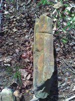
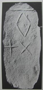
I was on a ridge line in the woods of Southern Ohio a couple weeks ago and stumbled across this rock. The rock is about 24" long, 4" wide, and 12 to 16" tall. One side has an "X", the other side has an "+", and the top has an elongated "T". FYI the "X" side faces due East.
Help, it's killing me not to know what it is -- grave stone?? property marker??
 

Attachments

  • Rock1.jpg
    Rock1.jpg
    243.7 KB · Views: 1,006
  • Rock2.jpg
    Rock2.jpg
    267.4 KB · Views: 1,000
  • Rock3.jpg
    Rock3.jpg
    167.5 KB · Views: 965
OP
OP
flip flop

flip flop

Sr. Member
Mar 3, 2010
274
53
East of West OhiO
Detector(s) used
Ace 250
Old Dog
There are multiple huge trees within 20 yards or so. The trees drew me to the area in the first place....looking for a good place to hang a tree stand for next fall's deer season.
I'm pretty new to this, do you think this area would be worth the time and effort of further site research??
Thanks
Flip Flop
 

Old Dog

Gold Member
May 22, 2007
5,860
397
Western Colorado
absolutely.
Take the metal detector along as well. look for sunken places such as foundations and bases for old long forgoten buildings.
never know what will turn up.
 

Springfield

Silver Member
Apr 19, 2003
2,850
1,383
New Mexico
Detector(s) used
BS
Looks like a land surveyor's marked stone property corner from the old days. Check the County Assessor's tax maps to see if you can correlate the rough location. Positive confirmation would take a lot more time, but could be done if you're curious enough.
 

OP
OP
flip flop

flip flop

Sr. Member
Mar 3, 2010
274
53
East of West OhiO
Detector(s) used
Ace 250
Thanks guys!
I'm curious enough to take the pictures to the local historical society on Monday. When finished there I'm going back to the site and study the rock a little closer.....move some debris and look for dates as Old Dog suggested.
Love this site, ya'll rock!!!!!
Flip Flop
 

Bum Luck

Silver Member
May 24, 2008
3,482
1,282
Wisconsin
Detector(s) used
Teknetics T2SE, GARRETT GTI 2500, Garrett Infinium
Primary Interest:
All Treasure Hunting
I'd say property marker.

Don't move it. It could mark someone's boundary.

Any trees around with blazes, usually chest high?
 

OP
OP
flip flop

flip flop

Sr. Member
Mar 3, 2010
274
53
East of West OhiO
Detector(s) used
Ace 250
Bum Luck,
To be honest, I didn't look. I'm headed back to the property Monday and, thanks to the TNEt family, am going to pay much closer attention to the surroundings / details on the rock.
Flip Flop
 

Bum Luck

Silver Member
May 24, 2008
3,482
1,282
Wisconsin
Detector(s) used
Teknetics T2SE, GARRETT GTI 2500, Garrett Infinium
Primary Interest:
All Treasure Hunting
A few thoughts.............

No one takes the effort to carve X's on rocks for no reason. It's hard work.

The idea that it marks treasure is highly unlikely. All the rocks with X's I see are boundary stones. Ohio is a PLSS state, which means they have mile square sections, and rules that dictate boundaries dependent on distant monuments.

You could check if it marks a current boundary, but even if it doesn't, it may mark an ancient one. As such, it may be part of the survey record that is very important to the adjoining or even more distant land owners, and as such should be preserved.

Our craft is a subtle one, and hard to understand, but I can tell you that there never is enough old boundary evidence to suit us, as things get lost or destroyed over time, and so they should not be disturbed even if they aren't an obvious boundary.

Thanks for understanding.
 

Springfield

Silver Member
Apr 19, 2003
2,850
1,383
New Mexico
Detector(s) used
BS
Bum Luck said:
A few thoughts.............

No one takes the effort to carve X's on rocks for no reason. It's hard work.

The idea that it marks treasure is highly unlikely. All the rocks with X's I see are boundary stones. Ohio is a PLSS state, which means they have mile square sections, and rules that dictate boundaries dependent on distant monuments.

You could check if it marks a current boundary, but even if it doesn't, it may mark an ancient one. As such, it may be part of the survey record that is very important to the adjoining or even more distant land owners, and as such should be preserved.

Our craft is a subtle one, and hard to understand, but I can tell you that there never is enough old boundary evidence to suit us, as things get lost or destroyed over time, and so they should not be disturbed even if they aren't an obvious boundary.

Thanks for understanding.

I agree with all you've said. I know a guy who bought a parcel of ground solely because one of his corners was a marked stone fom an 1890's survey of the adjoining parcel. He found it one day while quail hunting and was certain it was some sort of a 'Spanish treasure marker'. Despite an explanation from the land surveyor who prepared his plat, which he didn't believe, he bought the dirt and dug a dozen holes with a backhoe - all empty of course. I guess people believe what they want to, no matter what.
 

OP
OP
flip flop

flip flop

Sr. Member
Mar 3, 2010
274
53
East of West OhiO
Detector(s) used
Ace 250
Don't worry ya'll, I'm NOT going to move the rock regardless of what it is. I am going to move some of the debris and look for other carvings as Old Dog suggested.......but that's it. I agree with all you have said Bum Luck, even the far fetched idea of the rock marking some long lost treasure. For me, it's not that tough to understand.

I'm pretty confident the local historical society will tell me the rock is indeed an old property marker. However, that little voice in the back of my head hopes they have no idea what the rock represents and they want grid coordinates to it.

Thanks Ya'll
Flip Flop
 

Springfield

Silver Member
Apr 19, 2003
2,850
1,383
New Mexico
Detector(s) used
BS
flip flop said:
... I'm pretty confident the local historical society will tell me the rock is indeed an old property marker. However, that little voice in the back of my head hopes they have no idea what the rock represents and they want grid coordinates to it.

Thanks Ya'll
Flip Flop

The local historian is not the person to ask. Ask the local land surveyor.
 

Bum Luck

Silver Member
May 24, 2008
3,482
1,282
Wisconsin
Detector(s) used
Teknetics T2SE, GARRETT GTI 2500, Garrett Infinium
Primary Interest:
All Treasure Hunting
Springfield said:
flip flop said:
... I'm pretty confident the local historical society will tell me the rock is indeed an old property marker. However, that little voice in the back of my head hopes they have no idea what the rock represents and they want grid coordinates to it.

Thanks Ya'll
Flip Flop

The local historian is not the person to ask. Ask the local land surveyor.

That's a big 10-4! No one else will have a clue.
 

Blind.In.Texas

Bronze Member
Sep 1, 2006
1,696
29
Lone Star State
Primary Interest:
All Treasure Hunting
Hope these help. The stone that is pictured is the one referred to as 'left'. Your's could be modern too. I was just searching for something else when I found this one.
 

Attachments

  • IMG_1176.JPG
    IMG_1176.JPG
    43.8 KB · Views: 621
  • IMG_1177.JPG
    IMG_1177.JPG
    71.3 KB · Views: 616

okey dokey

Full Member
Mar 23, 2009
160
44
Muskogee
BIT,
I'd be interested in where the article about Gloria Farley came from. I have numerous of her other writings.
okey dokey
 

OP
OP
flip flop

flip flop

Sr. Member
Mar 3, 2010
274
53
East of West OhiO
Detector(s) used
Ace 250
Well I should have listened to ya'll......the Historical Society had no clue!

I spoke with a guy that has been a land surveyor for 30+ years. He confirmed the rock is in fact a property marker and that over the years the majority of the ones placed in Southern Ohio have been removed / stolen. I just have one question, why??

Flip Flop
 

Blind.In.Texas

Bronze Member
Sep 1, 2006
1,696
29
Lone Star State
Primary Interest:
All Treasure Hunting
flip flop said:
Well I should have listened to ya'll......the Historical Society had no clue!

I spoke with a guy that has been a land surveyor for 30+ years. He confirmed the rock is in fact a property marker and that over the years the majority of the ones placed in Southern Ohio have been removed / stolen. I just have one question, why??

Flip Flop
Cuz the carvings look neat.
 

Springfield

Silver Member
Apr 19, 2003
2,850
1,383
New Mexico
Detector(s) used
BS
Blind.In.Texas said:
flip flop said:
Well I should have listened to ya'll......the Historical Society had no clue!

I spoke with a guy that has been a land surveyor for 30+ years. He confirmed the rock is in fact a property marker and that over the years the majority of the ones placed in Southern Ohio have been removed / stolen. I just have one question, why??

Flip Flop
Cuz the carvings look neat.

Yep - conversation piece in the garden.
 

Shortstack

Silver Member
Jan 22, 2007
4,305
416
Detector(s) used
Tesoro Bandido II and DeLeon. also a Detector Pro Headhunter Diver, and a Garrett BFO called The Hunter & a Garrett Ace 250.
Primary Interest:
All Treasure Hunting
Blind.In.Texas said:
flip flop said:
Well I should have listened to ya'll......the Historical Society had no clue!

I spoke with a guy that has been a land surveyor for 30+ years. He confirmed the rock is in fact a property marker and that over the years the majority of the ones placed in Southern Ohio have been removed / stolen. I just have one question, why??

Flip Flop
Cuz the carvings look neat.

....................and would look GREAT in some city-slicker's flower garden.
 

Top Member Reactions

Users who are viewing this thread

Top