You are using an out of date browser. It may not display this or other websites correctly.
You should upgrade or use an alternative browser.
You should upgrade or use an alternative browser.
Old Hand Dug Holes Found And What Took Me There
- Thread starter dsty
- Start date


dsty
Bronze Member
- Thread starter
- #42
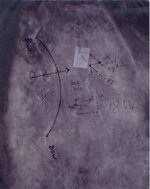
This goes with the last post, four corner dots, a 3mm X 7.5 CM deep drill hole and even tho the four corner marks are there and the head turns you to the left, the drill holes say to back track, theres probably 25 dig here symbols in a 1000 ft square, that's when your mineral detector comes into play. The land owner wants to charge you 100 dollars a day and he will not sign a contract. This is one that does not have a hand dug hole, it does have a Tc or 23X10 =230 Cm for a depth of 90 inches or seven ft 6 inches. I did this one back in the 80s before I had sense to look for bears , rabbits or such. I would consider this to be a map
Attachments

dsty said:Different, Measure the bottom for distance, take out that line it leaves a tunnel symbol, use the head ( usually round ) = a compass ( remove the compass ), this one turns to the left, whats left is a square box, theres a something interesting in a nearby tunnel. Brent could you do your magic and reduce the size of this. Thank you
Attachments


Shortstack
Silver Member
- Jan 22, 2007
- 4,305
- 416
- Detector(s) used
- Tesoro Bandido II and DeLeon. also a Detector Pro Headhunter Diver, and a Garrett BFO called The Hunter & a Garrett Ace 250.
- Primary Interest:
- All Treasure Hunting
dsty:
I'm recording the info you post; including your photos. I will not publish or reproduce your photos for anyone or anything other than my computer records. I hope you don't mind. I discovered that Microsoft Wordpad can be used to save your posts and put in the photos. It even lets you re-size photos within the app.
I apologize for not getting your permission ahead of time. If you'd rather I do not copy your photos, please let me know and I will delete them from my files.
dsty
Bronze Member
- Thread starter
- #45
SS you or anyone else are more than welcome to use them in any way you wish, its fun for me to relive the past. I remember standing on Ketchums Bluff and heart racing, WOW an arrow now what because it went west up Red River, Went around that hill side like an ant and then after months of looking I contacted Mr Skinner and with his his help I found the cross across and up River2.5 miles. I believe it led to a storage vault, its my one and only. After thinking about it now I think the backward part of the arrow may have pointed to the one at Petersburg cemetery. Good Grief. Theres a guy that may post the Photos that lives in the area, same thing with reverse on the cross could possible point to another farther West, the drill hole in a boot I don't think they Scattered their caches willy nilly I think they point from one to another, a trail so to speak frontward and backward. Sure wish I could recapture about 20 years BIG OLE TRAIL PATTERNS be safe out there folks
Shortstack
Silver Member
- Jan 22, 2007
- 4,305
- 416
- Detector(s) used
- Tesoro Bandido II and DeLeon. also a Detector Pro Headhunter Diver, and a Garrett BFO called The Hunter & a Garrett Ace 250.
- Primary Interest:
- All Treasure Hunting
Thank you, dsty. I really appreciate it. 
dsty
Bronze Member
- Thread starter
- #48
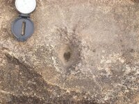
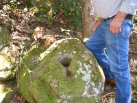
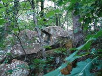
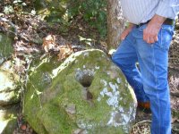
Thank you Odd, it is my pleasure when I can help someone, and appreciate the kind words. Its frustrating when I try to do something like posting a photo and it comes out all wrong. I think I have some that will be better/ easier to read of the map that I'm trying to post, the bunny rabbit and such. I sure hope it helps someone to get on the trail, Trail markers, Site markers, and cache markers, how to get close to what you seek, You may spend 90 percent of your time looking at, here it is, no here it is and they will all be exactly what you makes you want to dig, get it on paper on a scale, distance, direction, you want to find triangles, the drill hole that I'm standing beside is a prime example, bunny rabbit head sticking its head out of the ground, I have turtle head, several dig here, a rock that's a upside down V, that means something covered and in the area probably within a 1000 feet circle.
Old Dog
Gold Member
Old Dog
Gold Member
Old Dog
Gold Member

Old Dog
Gold Member
dsty
Bronze Member
- Thread starter
- #54
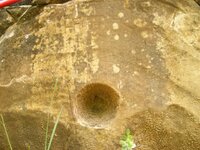
Thank you Thom, it made my day, invert the color on the drill hole with the heart in the bottom and you can see the bear foot print around the edge, the horzonial hole is a dig here and has a sleeping lamb on top with deer tracks in the bottom, the deer tracks say leaving a safe place, The fighting fish may be the only one in this area, it tells one to go this way, no go this way,I've seen snakes the same way, facing each other, it has eggs in its tummy. The rabbit head sticking out of the ground with the drill hole and arrow sure makes a good dig here sign, in fact they all say dig here, but we know better don't we. Thanks Ernie
dsty
Bronze Member
- Thread starter
- #55
If I had only one sign that I could post near a cache site it would be the V, notch, mouth, or whatever its called, it can be a roman numeral 5-- 50--- 500, it can be a letter of the alphabet 22-- 220 usually stands for depth 220 cm = 86 inches. There's lots of them around
Old Dog
Gold Member
dsty
Bronze Member
- Thread starter
- #57
Some of the things that I've seen and have reason to believe there something more to it, is an arrow, cross, turkey track, snake, bear, elephant, everything that has a head and a rear there's a good chance that there will be something both ways forward and backward, indicating a trail marker, if its only a head just the one direction, I could use some help with this one, some from the west and someone from the east, north or south. They may be measured by the league. Thanks
Shortstack
Silver Member
- Jan 22, 2007
- 4,305
- 416
- Detector(s) used
- Tesoro Bandido II and DeLeon. also a Detector Pro Headhunter Diver, and a Garrett BFO called The Hunter & a Garrett Ace 250.
- Primary Interest:
- All Treasure Hunting
Dsty:
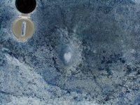
Does this mark up make any sense to you? I've loosely outlined an owl with a pointer line from it's wing going up the side of the hole to graze just past the lobe of another heart. There is either a rounded "M" or a bird sign that comes from under the compass body to the ear of the owl I outlined. I didn't outline it because, frankly, I just saw it. (sigh)

Does this mark up make any sense to you? I've loosely outlined an owl with a pointer line from it's wing going up the side of the hole to graze just past the lobe of another heart. There is either a rounded "M" or a bird sign that comes from under the compass body to the ear of the owl I outlined. I didn't outline it because, frankly, I just saw it. (sigh)
dsty
Bronze Member
- Thread starter
- #59
Good eye SS on the owl, That's part of the stacked line of league square's from the South Canadian River to "Wewoka Woods" a Church summer retreat and the last one north that I worked was at Chimney Rock East of Seminole, which is about 30 miles or 12 leagues north of the river, they stacked them kinda like they do sections now days, several horse heads, snakes, feather's, steer heads, layed out in a square at the corners. with several dig here symbols.
Top Member Reactions
-
 2392
2392 -
 1139
1139 -
 1098
1098 -
 896
896 -
 826
826 -
 803
803 -
 766
766 -
 738
738 -
 617
617 -
 505
505 -
 493
493 -
 474
474 -
 468
468 -
 426
426 -
 400
400 -
 393
393 -
O
369
-
 365
365 -
 363
363 -
 362
362
Users who are viewing this thread
Total: 2 (members: 0, guests: 2)
