Old Hand Dug Holes Found And What Took Me There

OP
OP
D

dsty

Bronze Member
Dec 2, 2007
1,300
736
Randal County
Great ! that is for sure a head and what I like about it is the 3 cm drill hole and the notched mouth that still has the cut out with it, those things are everywhere and as far as I know the meaning is directional ( go toward the open V ) shows a triangle 3 corners, same with a square cut out except 4 corners, I've seen square and rectangle cut outs on Thoms site a bunch of times, this one tells you to go this way and this is one corner,
 

OP
OP
D

dsty

Bronze Member
Dec 2, 2007
1,300
736
Randal County
Post # 46 shows a windrose as far as I can tell, there was three symbols, one was a tear drop rock with a map on the bottom that shows as the post shows, 90 feet from that on top of the hill was a 4 inch X 4 inch drill hole that indicated 330 degrees and a cordell ( 189 feet ) The next symbol was a 8" X 4" deep drill hole that indicated 2 cordell, there was a multitude of dig, here symbols fighting fish, a triangle stuck into the ground, Armadillo, lambs head, a triangle sitting on top of the ground 8 inches wide X 24 inches high X 32 inches long, a turtle head sticking out of the ground, man made circle of earth similar to what you might find sitting over a teepee,from the 8X4 inch drill hole a large rock with a 3 inch X 3 inch horzional hole with deer tracks reverse of 335 degrees in the bottom and a C with the open side facing down and the horzonial hole was in the middle, ( the 3X3 inch indicated feet ) The rock had a resting / sleeping lamb on top. another dig here. Continue on at 335 degrees and 65 feet you find a 4 X 4 inch drill hole on a angle that indicates ( viking mooring hole to the north ) a cordell ( 189 feet ) , lots of good looking spots to dig, continue on at 335 degrees and find a match for the 1st measurement at 90 feet the rock was it was in the shape of a bunny head with another 4 inch X 4 inch drill hole also on a angle ( 33 degrees ) sorry don't remember the measurement. Anyway the hole I found using the degrees and measurements matched both
 

OP
OP
D

dsty

Bronze Member
Dec 2, 2007
1,300
736
Randal County
Just thought I would inject something here, look at your diamond carving, Cross, square box or anything else that has a possibility of having four directions, it may very well that all four directions will be correct and the distance could be 2.5 miles, all that I have seen ( diamonds / Cross / crossed arrows seem to be toward North/ West / South / East, which will fit the theory that the folks stacked the sites of interest every 2.5 miles and you can follow them North, West, South, and East, one Cross that I found on the south bank of the Red River that had a broke arm which indicated 3 this way, I know for a fact that one did go East one went West and one went South to where the the Baths were found, Got to go outside the box on some of this stuff.
 

OP
OP
D

dsty

Bronze Member
Dec 2, 2007
1,300
736
Randal County
Thanks Thom, I appreciate all my friends and wish them well, all the stuff I post I know to be true, one site had a carved diamond attached with a symbol and also there was a hewn stone 1 1/2 inches thick and 20 inches long / 8 inches wide with 2 - 1 inch square eyes ( look here ) they were both pointing the 4 directions,Its seems that they did use patterns on a lot of stuff.
 

OP
OP
D

dsty

Bronze Member
Dec 2, 2007
1,300
736
Randal County
This is gonna kinda like I'm running a trail in the dark, I gave all my treasure books to a Chaplain for his library in Afghanistan except for two, one is which Gale R. Rhodes Waybill To Lost Spanish Mines And Treasures / Dream Garden Press / 1982, signed by my son in crayon once when I forgot and left it on the coffee table when he was about 2 years old. Before that I used books by I think they were the Pennington's from NM. What I have in mind is talking about Diamonds, crosses and anything that's got 3 or 4 directions carved on rocks, layed out with stones, six X six inch deep trenches, some stand for degree's but the ones that I am interested in is distance, the directions for the most part will be shown corner to corner and will be the West , North, East, and South. The distance may be 1/2 diamond ( triangle 3 directions ) 1/2 league, full diamond 1 league, diamond inside a diamond 1 and 1/2 league, 2 leagues 2 diamonds connected,These diamonds can and are sometimes chipped out around drill holes. Allways watch for the chipped out around all carvings, sometimes you have to invert color to see them, Thom showed me that trick, Obsolete Spanish and Portuguese units of measurements are very helpfull also
 

OP
OP
D

dsty

Bronze Member
Dec 2, 2007
1,300
736
Randal County
Hello Casca, I thought everbody knew what a windrose is all about sorry. Here's a 1/4 inch angle hole 7 cm deep on a map that's on a rock with directions to the other angled small drill hole, it is on about a 10/15 degree angle. that's on post # 41 The windrose is on post # 48, you got to hunt it, there,s others also on this thread but they are scattered and I don't know where they are at but BIT has one with info on his site, I didn't draw a line between the triangles on my site but the distance was 3 cordells and the direction was 335 degrees, every thing is important,
 

OP
OP
D

dsty

Bronze Member
Dec 2, 2007
1,300
736
Randal County
Hello Rangler,post # 41, this set of drill holes 1/2 walnut for the 4 corners, the 3mm hole on a angle 7cm deep, the drill holes that reverses the direction and smaller drill hole indicates measure by the foot and how many, the post # 42 is within 24 inches as a mater of fact you can see the corner of the map rock when looking at the one with the one that seems to indicate a left turn, it shows 6 directions Guess you folks that's interested will have to go to " old hand dug holes and what took me there ", post # 41 and post # 42 can't seem to get them posted. sorry
 

Old Dog

Gold Member
May 22, 2007
5,860
397
Western Colorado
Back to the top old friend.
 

Attachments

  • BUMP.jpg
    BUMP.jpg
    41.7 KB · Views: 581
  • BUMP.jpg
    BUMP.jpg
    41.7 KB · Views: 569

Shortstack

Silver Member
Jan 22, 2007
4,305
416
Detector(s) used
Tesoro Bandido II and DeLeon. also a Detector Pro Headhunter Diver, and a Garrett BFO called The Hunter & a Garrett Ace 250.
Primary Interest:
All Treasure Hunting
Just curious, Cleveland B. What made you decide to dig in those 2 spots??
 

Cleveland B.

Jr. Member
Jun 25, 2011
56
41
Primary Interest:
Beach & Shallow Water Hunting
Shortstack,

The two spots are general extensions of lines drawn between
suspect markers such as possible pointer trees,
weathered rock carvings and the like.


Thanks
 

Shortstack

Silver Member
Jan 22, 2007
4,305
416
Detector(s) used
Tesoro Bandido II and DeLeon. also a Detector Pro Headhunter Diver, and a Garrett BFO called The Hunter & a Garrett Ace 250.
Primary Interest:
All Treasure Hunting
Cleveland B:
Keep in mind that measurements of 66 feet is also a player. I think 16.5 feet has also been found useful, but not real sure. That's one half of 33 (obviously) and one fourth of 66.
If you're running a KGC trail, talk to Texas Jay and Rebel KGC about your ideas. They are 2 folks who are highly knowledgeable about the subject.
 

gord

Hero Member
Mar 30, 2005
529
41
London, ON
Shortstack said:
Cleveland B:
Keep in mind that measurements of 66 feet is also a player. I think 16.5 feet has also been found useful, but not real sure. That's one half of 33 (obviously) and one fourth of 66.
If you're running a KGC trail, talk to Texas Jay and Rebel KGC about your ideas. They are 2 folks who are highly knowledgeable about the subject.

66' = 1 chain (100 links)
16.5' = 1 rod
- old standards for land survey.
 

Shortstack

Silver Member
Jan 22, 2007
4,305
416
Detector(s) used
Tesoro Bandido II and DeLeon. also a Detector Pro Headhunter Diver, and a Garrett BFO called The Hunter & a Garrett Ace 250.
Primary Interest:
All Treasure Hunting
gord said:
Shortstack said:
Cleveland B:
Keep in mind that measurements of 66 feet is also a player. I think 16.5 feet has also been found useful, but not real sure. That's one half of 33 (obviously) and one fourth of 66.
If you're running a KGC trail, talk to Texas Jay and Rebel KGC about your ideas. They are 2 folks who are highly knowledgeable about the subject.

66' = 1 chain (100 links)
16.5' = 1 rod
- old standards for land survey.

Very good points, gord. That info dovetails nicely with the KGC numbers of 33 and 66. All of these numbers were not only used for distance measurements, but were also used for varying compass headings and, I think in some cases, item counts.
 

oddrock

Hero Member
Apr 7, 2010
560
86
Detector(s) used
Garrett , Minelab ,White's, others and B.S. sniffer
CB

Nice new avatar...do you view as a bird at the turtles ear?
Plow points....some were mounted where the info would be on the back (moleboard or breaking plow points) otherwise it would have wore off with the first days plowing. The plow point you posted may have been on an early planter.
Hope this helps.

Oddrock
 

Old Dog

Gold Member
May 22, 2007
5,860
397
Western Colorado
gord said:
Shortstack said:
Cleveland B:
Keep in mind that measurements of 66 feet is also a player. I think 16.5 feet has also been found useful, but not real sure. That's one half of 33 (obviously) and one fourth of 66.
If you're running a KGC trail, talk to Texas Jay and Rebel KGC about your ideas. They are 2 folks who are highly knowledgeable about the subject.

66' = 1 chain (100 links)
16.5' = 1 rod
- old standards for land survey.

1 Rod=166 inches
1 chain=66 feet
40 rods = 1 furlong
8 furlongs =1 mile

common KGC stuff.
these are the measurements that were used at this time in history.
 

OP
OP
D

dsty

Bronze Member
Dec 2, 2007
1,300
736
Randal County
The only drill hole that I have seen that had a plug was a round soft- ball size rock covering a 3" X 3" drill, yours may indicate measure X cordell, = distance for the distance and V for direction
 

oddrock

Hero Member
Apr 7, 2010
560
86
Detector(s) used
Garrett , Minelab ,White's, others and B.S. sniffer
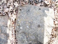
Hellow Dsty

I have enjoyed your posts, thought you would enjoy this set of holes. (sorry about the shadow over the rock, I lightened it the best I could)

Oddrock
 

Attachments

  • DSCF3839 (640x480).jpg
    DSCF3839 (640x480).jpg
    151.5 KB · Views: 406

Top Member Reactions

Users who are viewing this thread

Top