Why is there a large cross on this mountain?

desertmoons

Bronze Member
Apr 16, 2008
1,067
168
Re: large cross on mountain top?

Well...this is just something I am researching a bit..long range things.....but a few things caught my eye. Do you often see angles like that as on the nearer mountain in your area? If not, it maybe artificial. And very sharp peaks as in the distance?

The other items are just things that caught my eye. No special knowledge..just things I would take a closer look at.
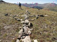
leadville 2010 018mk.jpg

Here is something sort of like it...in a small way. I tend to think of these as masts on a ship so far.
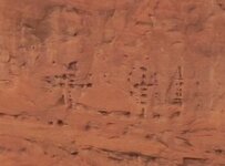
crossmstpecked.jpg
 

OP
OP
colorado14ers

colorado14ers

Bronze Member
Jul 3, 2010
1,530
6
Naples, Fl
Detector(s) used
whites M6, Surfmaster PI
Re: large cross on mountain top?

wow!!!! you all are a treasure chest of information, and i thank you :notworthy: :). But that was in colorado and now i am back in Naples so it is going to be hard to give you anymore info on the rocks or the mountains around them :-[. sorry I didn't take notes on the surroundings because I didn't think anything of them when I saw them :-[.
 

Blind.In.Texas

Bronze Member
Sep 1, 2006
1,696
29
Lone Star State
Primary Interest:
All Treasure Hunting
Re: large cross on mountain top?

Shortstack said:
Would that be Hippie Presbyterians or Presbyterian Hippies?
Anyway, would they have also carved stones into the shape of animals
such as that one of a duck and the other as a rabbit?
I have moved my comments, to shortstack, into the OFFICE thread.
 

OP
OP
colorado14ers

colorado14ers

Bronze Member
Jul 3, 2010
1,530
6
Naples, Fl
Detector(s) used
whites M6, Surfmaster PI
Re: large cross on mountain top?

lovnit said:
Perhaps there is someone in Colorado that would want to pick up/persue this if you were not interested in the site anymore? I would also like to state that if this were made by hippies (which I highly doubt) they would also have to have a fire pit close by for food or heat as they probably would spend more than a day, not to mention the trash that is always present at their sites.

Maybe RGINN would like to look this up, I think he live near where this is. It was taken on cottonwood pass if anyone is around there. Its not that I dont care, its just that I didnt think it was anything when I found it and I didnt take notes and Im back in floirda now. Ask RGINN if he is interested in this :dontknow:.
 

Springfield

Silver Member
Apr 19, 2003
2,850
1,383
New Mexico
Detector(s) used
BS
The 'Treasure Mountain' legend is a cover story for a KGC cache in the vicinity. The story is all fabricated, but it does put you in the right ball park.
 

Springfield

Silver Member
Apr 19, 2003
2,850
1,383
New Mexico
Detector(s) used
BS
Cat Jockey said:
I am not circling rocks or outlining elephants and mermaids or such. I am circling things that draw my attention to the age of this site.

This was not done yesterday guys.

Hard to say what the age of this thing is. A number of the rocks look 'set in' due to a build up of blow sand and the vegetation that grows in the new deposited dirt. I suspect the build up has reached equilibrium and stopped due to the high winds and lack of soil - this site is on the Continental Divide above 12,000', after all (more about that below). If you compare these rocks to the undisturbed ones in the photo you see a lot of similarities, but I'm not sure I'd draw any conclusions from that observation. Age? Based on similar markers I've personally constructed under milder circumstances, I'd say 25 years minimum as a SWAG.

Now ... who did it and why? I'll stick with hippies (or yuppie hikers if you prefer) as my first guess. The site is accessible by vehicle, it's just south of a pass, and it's on the Continental Divide (is the CD Trail nearby?). The 'medicine wheel', or 'Celtic cross', or 'compass rose' theme seems to fit the statements young folks might leave in a place like this. My second choice, probably a long one, would be trappers from the 1820-1840 period. I'll have to dig out my maps on their routes and see if this pass was used. These trappers, operating out of Taos, covered an incredible amount of territory - there was virtually nowhere in the Four Corners states that they didn't see. The arm pointing to the San Luis Valley may be telling.

Treasure sign? I'll give you a weak 'maybe' just to keep your spirits up, but if so, what are you going to do with it? By the way, CJ, I'll have something to say on your 'cover story' question when I get around to replying to your recent posting concerning the LUE legend over on that other thread. You've got a good grasp of reality, it seems.
 

OP
OP
colorado14ers

colorado14ers

Bronze Member
Jul 3, 2010
1,530
6
Naples, Fl
Detector(s) used
whites M6, Surfmaster PI
Springfield said:
Cat Jockey said:
I am not circling rocks or outlining elephants and mermaids or such. I am circling things that draw my attention to the age of this site.

This was not done yesterday guys.

Hard to say what the age of this thing is. A number of the rocks look 'set in' due to a build up of blow sand and the vegetation that grows in the new deposited dirt. I suspect the build up has reached equilibrium and stopped due to the high winds and lack of soil - this site is on the Continental Divide above 12,000', after all (more about that below). If you compare these rocks to the undisturbed ones in the photo you see a lot of similarities, but I'm not sure I'd draw any conclusions from that observation. Age? Based on similar markers I've personally constructed under milder circumstances, I'd say 25 years minimum as a SWAG.

Now ... who did it and why? I'll stick with hippies (or yuppie hikers if you prefer) as my first guess. The site is accessible by vehicle, it's just south of a pass, and it's on the Continental Divide (is the CD Trail nearby?). The 'medicine wheel', or 'Celtic cross', or 'compass rose' theme seems to fit the statements young folks might leave in a place like this. My second choice, probably a long one, would be trappers from the 1820-1840 period. I'll have to dig out my maps on their routes and see if this pass was used. These trappers, operating out of Taos, covered an incredible amount of territory - there was virtually nowhere in the Four Corners states that they didn't see. The arm pointing to the San Luis Valley may be telling.

Treasure sign? I'll give you a weak 'maybe' just to keep your spirits up, but if so, what are you going to do with it? By the way, CJ, I'll have something to say on your 'cover story' question when I get around to replying to your recent posting concerning the LUE legend over on that other thread. You've got a good grasp of reality, it seems.
cant do anything with it but anyone is welcome to do whatever they want with it ;D. you guys are just full of info, thanks :)
 

hadji009

Hero Member
Dec 29, 2008
711
193
illinois
Cat Jockey said:
I am not circling rocks or outlining elephants and mermaids or such. I am circling things that draw my attention to the age of this site.

This was not done yesterday guys.
if the things in red are the only thing you are looking at then you need to spend time on a landscaping web site not a treasure site. brent
 

Springfield

Silver Member
Apr 19, 2003
2,850
1,383
New Mexico
Detector(s) used
BS
CJ,
Yeah, the Rainbow Family has held two gatherings here in the Gila/Mimbres country since I relocated here from the CO western slope in '74. The core group was harmless, upstanding and intriguing, but unfortunately they have always been plagued by a cadre of wannabes and runaways who tag along for various reasons.

The trappers were able to determine direction easily (sun & stars) and distance fairly well. They spent most of their time up and down drainages, where the beaver was, and traveled the ridges and passes into the next drainages. They marked with tree blazes, rock cairns and, rarely, rock carvings. They knew the country intimately decades before Anglo settlement. I would guess they would have been able, by dead reckoning, to have constructed the rock pattern at Cottonwood Pass. The accuracy? Hard to say, but possibly much better than we suppose. I still place 20th century hikers who had access to maps and compass as my number one guess.

Spanish explorers? I'll grant you this possibility for arguement's sake. Their tools were essentially no better than the trappers'. Even if they had an experienced navigator with them, they only had the ability to establish their latitude reasonably accurately (north/south position). They were plagued with the same problem that even their sea-faring pals had: no way to establish longitude (eat/west position). Therefore, the triangulation theory goes out the window. They dealt with distance, direction, trails and landmarks too.
 

Top Member Reactions

Users who are viewing this thread

Latest Discussions

Top