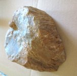
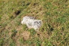
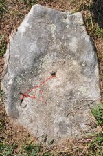
Backwards J

jayheazy

Jr. Member
Oct 13, 2007
43
0

Attachments

  • 1.jpg
    1.jpg
    215.8 KB · Views: 898
OP
OP
J

jayheazy

Jr. Member
Oct 13, 2007
43
0
Also found these in the vicinity. Native american?
 

Attachments

  • 2.jpg
    2.jpg
    222.7 KB · Views: 839
  • 3.jpg
    3.jpg
    259.5 KB · Views: 849

Shortstack

Silver Member
Jan 22, 2007
4,305
416
Detector(s) used
Tesoro Bandido II and DeLeon. also a Detector Pro Headhunter Diver, and a Garrett BFO called The Hunter & a Garrett Ace 250.
Primary Interest:
All Treasure Hunting
Do you plan to clean out and take measurements of that drill hole?
 

stevesno

Hero Member
Feb 27, 2006
714
74
Deep in the Ozark Mountains
Detector(s) used
Fisher CZ3D, Whites TM 808, Sharptronics DSP-03
Primary Interest:
All Treasure Hunting
Shortstack said:
Do you plan to clean out and take measurements of that drill hole?
Shortstack...Drillholes confuse me...So once the measurement is taken...do you take depth x width to get a distance...or bearing? Which you would use to find your next clue?....Thanks, Steve
 

dsty

Bronze Member
Dec 2, 2007
1,300
736
Randal County
Hello Steve, there's so much about drill holes that's unknown, for the most part those that I have followed all have information to glean, if that's a drill hole it may not be associated with the backward J, usually the proper direction to follow is the long part of the shaft however because its backward follow it from top to the bottom, the one that I followed indicated a left turn but I had more information it was 45 X 10 ( J ) = 450 feet and it was a left turn off of a corner of a triangle, small drill holes should be measured in feet and not vara, indicate direction, depth of a cache,how deep is it, is it on a angle, is there anyhing else on the other rocks in the vicinity, not very many folks are interested in drill holes or they would post them, share or get involved.
 

stevesno

Hero Member
Feb 27, 2006
714
74
Deep in the Ozark Mountains
Detector(s) used
Fisher CZ3D, Whites TM 808, Sharptronics DSP-03
Primary Interest:
All Treasure Hunting
dsty said:
Hello Steve, there's so much about drill holes that's unknown, for the most part those that I have followed all have information to glean, if that's a drill hole it may not be associated with the backward J, usually the proper direction to follow is the long part of the shaft however because its backward follow it from top to the bottom, the one that I followed indicated a left turn but I had more information it was 45 X 10 ( J ) = 450 feet and it was a left turn off of a corner of a triangle, small drill holes should be measured in feet and not vara, indicate direction, depth of a cache,how deep is it, is it on a angle, is there anyhing else on the other rocks in the vicinity, not very many folks are interested in drill holes or they would post them, share or get involved.
Dusty great to hear from you! I know that there is no 1 correct answer...But in this case with the backward J.... what measurement would you use to measure the depth and width of the drillhole....centimeters? And then add them together....and multiply it by 10 (J)....Would this be a good starting point? Or am I way off?.....Thanks for your help....Steve
 

dsty

Bronze Member
Dec 2, 2007
1,300
736
Randal County
Steve I do not believe the J associated with the drill hole at this point, I believe the J is simply used to mark a corner, I believe it to be outlaw, possibly KGC, I would look over an area of at least 1/2 mile square,be sure to look for rock patterns, is there a horse shoe bend in a creek or a sharp turn in a creek, an old school nearby , old cemetery. The drill hole of that size is strange because its alone, it could be that it simply says this is where you start, its possible that the J is two in one J an a T or T U its possible that its natural, without more information I am at a loss, if there's three in a pattern ( 3 corners then its possible that you have a blind corner somewhere but you still need all the information ) how far apart are the 3 stones, whats the compass reading. Keep in touch Ernie
 

OP
OP
J

jayheazy

Jr. Member
Oct 13, 2007
43
0
I found these along the blue ridge parkway. I was out with my daughters that day and completely unprepared ,no compass, measuring tape, gps anything. We were playing in a field on top of a mountain and there they were. I think it is one of the best signs I have found.

The other rocks looked to be burned, then the (white) markings were added.
 

goverton

Sr. Member
Oct 9, 2010
407
45
Primary Interest:
All Treasure Hunting
square the T in the top part of J
Draw line to drill hole and a line extended from top OF J
measure angle

I would then go that direction
 

Attachments

  • Backward J.jpg
    Backward J.jpg
    203.7 KB · Views: 725

Top Member Reactions

Users who are viewing this thread

Top