Big Heart on top of mountain

uthunter

Full Member
Sep 7, 2010
106
1
Cache County, Utah
Not sure if this is the right place to post this, if not please move it.

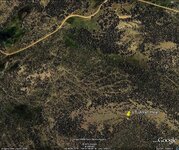
In the Uinta mountains, just East of Paradise Peak, there is a big white heart on top of the mountain. The heart is about to 100 ft tall by 100 ft wide.

You can see it in Google Earth. Type in "Paradise Peak, Vernal, UT" into the search bar for Google Earth. Then zoom in to about 1000 ft or less then go East about 1/4 mile or so. Here are the GPS coordinates for it as well: 40 40' 12.89" N 109 57' 14.66" W. You could cut and past the coordinates too.

Here is the pic of the heart for those who do not have or want to install Google Earth.

Heart.jpg
 

S

Smee

Guest
Use Google's "3D" feature with your center mouse button. Lower your point of view and see what is pointed TO and what is pointed away from . . . as well as aligning those other white spots to either side of the heart.

It's probably nothing but an anomaly, but I find what it's pointing away from to be a bit out of place as well as the heart. In Google earth, it looks like the moon is half buried in the earth.

moon.jpg
 

Treasure finder

Sr. Member
Apr 4, 2006
464
60
Los Angeles
Detector(s) used
Garrett Infinium, Compass Gold Scanner, Maxi Pulse, Gardner with a 3 foot loop, PDF1000, & Dowsing rods,
A heart usually denotes the trail to gold or treasure, but they can usually be clearly seen from the ground,
Could Spanish Miners see this from the ground, no airplanes back then. Interesting to see the trails going
up to it. Is it vertical or entirely horizontal/
Rich
 

Shortstack

Silver Member
Jan 22, 2007
4,305
416
Detector(s) used
Tesoro Bandido II and DeLeon. also a Detector Pro Headhunter Diver, and a Garrett BFO called The Hunter & a Garrett Ace 250.
Primary Interest:
All Treasure Hunting
Don't overlook the possibility that a group of folks put that there as a general sign or "message" for people at large. Don't you remember the "Peace and Love" of the free love 60s? This might be the same idea that caused other college students to "post" their school's name or mascot on the side of a mountain. Isn't there something up on the side of a mountain close to Salt Lake City? Toward the ski areas?
 

Old Dog

Gold Member
May 22, 2007
5,860
397
Western Colorado
All good questions.
I would like to know as Smee stated can you see it from a distance?
if so ...how far?
there are reasons for the questions and I will gather the info for a longer post that explains why.
If this mark can be seen for up to 8-10 miles away It is very important.
 

OP
OP
uthunter

uthunter

Full Member
Sep 7, 2010
106
1
Cache County, Utah
I just posted a reply and I don't see it. So here goes again....

You can only see it from the air, possibly from Paradise Peak. From the nearby peak, you would not be able to line it up with anything. It is several hundred feet lower than the peak, and on top of the ridge. The point of the heart points due South towards the Indian res maybe ten miles by air. Paradise Peak is to the east of Whiterocks Canyon. I have not looked to see where it might be pointing to. To the North is some bare hills, most less than 500 ft high. The nearest hiking trail is maybe a mile or more away.

I was playing around with Google Earth when I found it, I live in a town named Paradise. I have no clue what, why or who put it there, but it would be and interesting story. If it is a trail pointer/marker, I must say it is one big marker, but you could not see it from the valley floor so, I think, it would do no good.

I found it interesting, so I thought I would post it.
 

Old Dog

Gold Member
May 22, 2007
5,860
397
Western Colorado
Try if you can to put boots on the ground and see if it doesn't show up from the neighboring mts.this may be the way it was meant to be viewed.
There are many other good signs visible in this area as it was mined prolifically by the Spanish. Especially to the North East.

I will post more about these type of markers in Basic signs later.
 

gollum

Gold Member
Jan 2, 2006
6,729
7,596
Arizona Vagrant
Detector(s) used
Minelab SD2200D (Modded)/ Whites GMT 24k / Fisher FX-3 / Fisher Gold Bug II / Fisher Gemini / Schiebel MIMID / Falcon MD-20
Primary Interest:
All Treasure Hunting
If you can only see it from the air or on Google Earth, then it was put there by Aliens or by people wanting to get "Google Earth Famous".

I don't remember exactly where it was, but some rich kid marked a giant penis on the roof of his parents huge home. When it became visible on Google Earth, it made headlines.

A lot of people have made a lot of "Land Sculptures" specifically to get on Google Earth.

I highly doubt the heart is Spanish. I doubt it is very old at all. That surface looks like dirt not rock. If it were dirt, then it would have grown over MANY years ago.

Best-Mike
 

OP
OP
uthunter

uthunter

Full Member
Sep 7, 2010
106
1
Cache County, Utah
Going to be next summer for me at the earliest before I can get out there and check it out. It could be the top soil was removed, the soil down a foot or two is almost white or a light tan color. Would be a major job tho to remove a foot of soil over an area that big. In Google Earth, in the lower left corner of the image, is a distance scale. I used it to measure the heart and it was about 100 x 100 ft. Way too much effort for me. Whoever did it tho, must have been really high to do put that much effort into something like that. Of course, it could be white wash, still a lot of effort since there is no water up there and it is like 11,000+ ft elevation.

I am just getting back on my feet (sort of) from some nasty back and neck injuries in 2003 that nearly paralyzed me. I am now able to walk about 1/2 mile at the most - most days, and not too quick as it is. In 2004 the doctors told me I would probably not be able to walk very far if at all. The said I would be in a wheel chair for the rest of my life. I have a wheel chair, but have only used it a few times in the last seven yrs. I proved them wrong, big time. I use a cane, but am working on getting rid of it as well. I may not be able to run, jump or walk very fast, BUT I CAN WALK.

Due to the injuries, I have been cooped up for way too long and am now getting back into treasure hunting. I did it from 1983 until I got hurt at work in 2003, I fell about thirty foot. Everything on treasure hunting that I had, I put in storage because I did not figure I would be able to treasure hunt ever again. I just got stuff out of storage (actually my son did, since I am still on a no lifting order) a few months ago and have started catching up to date, in a manner of speaking.
 

gollum

Gold Member
Jan 2, 2006
6,729
7,596
Arizona Vagrant
Detector(s) used
Minelab SD2200D (Modded)/ Whites GMT 24k / Fisher FX-3 / Fisher Gold Bug II / Fisher Gemini / Schiebel MIMID / Falcon MD-20
Primary Interest:
All Treasure Hunting
Looks like a pretty easy drive with a 4x4.

Best-Mike
 

Attachments

  • utheart1.jpg
    utheart1.jpg
    153.4 KB · Views: 456

Shortstack

Silver Member
Jan 22, 2007
4,305
416
Detector(s) used
Tesoro Bandido II and DeLeon. also a Detector Pro Headhunter Diver, and a Garrett BFO called The Hunter & a Garrett Ace 250.
Primary Interest:
All Treasure Hunting
In gollum's photo, are those light colored lines above and to the left of the pin ski runs or cross country ski trails?
 

Old Dog

Gold Member
May 22, 2007
5,860
397
Western Colorado
Backing off a bit makes the place look really familiar.
I mean world famous.
Is this close to Park City?

People will do a lot of things to get noticed when the Olympics are in your area.
 

Treasure finder

Sr. Member
Apr 4, 2006
464
60
Los Angeles
Detector(s) used
Garrett Infinium, Compass Gold Scanner, Maxi Pulse, Gardner with a 3 foot loop, PDF1000, & Dowsing rods,
Uthunter,
Another thought, most Spanish Signs are supposed to be permanent which means "made out of rock".
I doubt if it is rock, only one that size in the area. Also granite weighs about 165 pounds per cubic
foot so that thing is way too heavy for any group to move from "where"? Also if the Spanish were
to have carved it, I would think they would carve something better seen from ground level.
As I said earlier, there seem to be some trails leading up to it. A bulldozer maybe? Maybe a landing
pad for forest service helicopters? A radar site or a site for a microwave radio tower?
All conjecture, thanks for sharing, it sharpens the wits.
Rich
 

S

Smee

Guest
gollum said:
Looks like a pretty easy drive with a 4x4.

Best-Mike
Don't know, here's a 3d Google Earth view from the road

Paradise Peak, Vernal, UT_1.jpg

This is a view from the peak looking about SSE. The yellow line starts at the heart and ends roughly 12 3/4 miles taking into account the topography of the land. Unfortunately, with no boots on the ground and no "telescope view" in google earth, it's hard to tell what it would look like.

Paradise Peak, Vernal, UT2.jpg

and the reverse of the second pic

Paradise Peak, Vernal, UT3.jpg
 

OP
OP
uthunter

uthunter

Full Member
Sep 7, 2010
106
1
Cache County, Utah
I didn't figure it was Spanish in origin. The soil up there is not granite, it is a real rocky poor soil with a light colored almost tan clay type soil. When it get wet, the tan soil that is, it sticks to your books like clay, but has more of a chalky feel to it when dry. and it can get real hard when it is dry. It can tough digging in it. My parents had this type of soil up north of the Weber river, where their cabin was.

Here is a pic of one of the circles, it is on a side of the hill about 3/4 the way up. Oh, and it is about 200 ft across, and at an elevation of 10,900 ft.

I posted the pic of the white heart and the circle above to show that not all signs are Spanish, especially like these, but there are plenty of real Spanish sings/symbols in the area.

I still think it would be interesting to hear the story behind the heart above.

Circle - 1.jpg
 

Shortstack

Silver Member
Jan 22, 2007
4,305
416
Detector(s) used
Tesoro Bandido II and DeLeon. also a Detector Pro Headhunter Diver, and a Garrett BFO called The Hunter & a Garrett Ace 250.
Primary Interest:
All Treasure Hunting
Is that heart shape the result of someone scraping the surface cover from the dirt? Like the Nasca Lines were done?
Try Bing with Birds Eye view.
 

OP
OP
uthunter

uthunter

Full Member
Sep 7, 2010
106
1
Cache County, Utah
If you go down deep enough, 12 to 20 inches or more, then the dirt does get a light tan and almost white in some other areas. I seriously doubt it is white wash, since there is no water up there, and the nearest trail is a mile or more away. If they did scrape the dirt off, where did it all go. Imean 100 ft x 100 ft and even six inches deep is a lot too move.

Kinda makes you go Hmmmmmm.
 

Shortstack

Silver Member
Jan 22, 2007
4,305
416
Detector(s) used
Tesoro Bandido II and DeLeon. also a Detector Pro Headhunter Diver, and a Garrett BFO called The Hunter & a Garrett Ace 250.
Primary Interest:
All Treasure Hunting
uthunter said:
If you go down deep enough, 12 to 20 inches or more, then the dirt does get a light tan and almost white in some other areas. I seriously doubt it is white wash, since there is no water up there, and the nearest trail is a mile or more away. If they did scrape the dirt off, where did it all go. Imean 100 ft x 100 ft and even six inches deep is a lot too move.

Kinda makes you go Hmmmmmm.

Well, no.................I would have to say,WHEW, dang glad I didn't have to do it!!! :laughing7:
 

OP
OP
uthunter

uthunter

Full Member
Sep 7, 2010
106
1
Cache County, Utah
I agree, glad I did not have to do it.

In topic post #9, you asked if the smaller horizontal lines are possible ski runs?

No they are not. The large tan line at the top is the F.S. access road to a campground up Whiterocks Canyon, that road is the one that starts down at the town of Whiterocks, goes up to Paradise Park lake and campground then continues up Whiterocks Canyon to the campground. I think the smaller lines are from a logging project from the 1970's era. There are several of sites, with those lines running all all over the area, in the Uintas.

Here is another site on the same mountain, with those smaller lines. The F.S. tank traps the trails and roads they don't want you driving on. The area is also closed to motorized vehicles, except on marked roads or trails only. You can hike, go on horseback pretty much any where; or use pedal style mountain bikes - in certain areas that is.


Logging Site.jpg
 

Shortstack

Silver Member
Jan 22, 2007
4,305
416
Detector(s) used
Tesoro Bandido II and DeLeon. also a Detector Pro Headhunter Diver, and a Garrett BFO called The Hunter & a Garrett Ace 250.
Primary Interest:
All Treasure Hunting
uthunter:
In my post #9, I was talking about that spiderweb-like network of tan lines that look like trails.
The area is just above and slightly to the left of the pin.
 

Top Member Reactions

Users who are viewing this thread

Top