Why would it be illegal to just walk, and write notes, and take photos? I mean, just don't take in any shovels..............................................................................................yet. Hmmmmmm?
Well that part would be fine. However, you can't do too much exploring because you can only see this and other things on a GUIDED tour by a park ranger. This being a national monument and all. After finding this I was compelled to make a facebook post about the uncanny coincidence of treasure sites being made off limits by our government creating parks and monuments, etc...
Why if I didn't know any better I'd SWEAR...naaaah! The government is only here to help us right? LOL..
Could it have been moved?
Could it still be on North side of River?
It would be fun to ck it out.
I still don't buy the Indian carving things.......I think Spanish Treasure......
Along the Canadian River, from New Mexico through Texas and into Oklahoma, numerous similar sites containing Antelope Creek-type petroglyphs have been excavated. In preparation for the Sanford Dam project back in the mid 1960's which flooded the region to create the Lake Meredith National Recreation Area many symbols carved into the dolomite rock were excavated throughout the area. Several miles upstream near the mouth of McDowell Creek in Big Canyon, another oversized footprint was discovered. Many other footprint, turtle and bison carvings have been found along the Canadian River and throughout the Panhandle Plains area as well
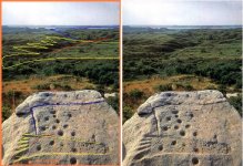
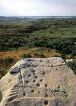
"Carved into the stones at the gallery are two turtles, a bison, an artificially large footprint and the now almost indiscernible man-like figure with his arms spread above his head. The two turtle carvings, placed next to each other but on separate rocks, set with their heads pointing in a northerly direction. As an observer facing north, the turtle on the left points to about 279 degrees north-northwest while the turtle on the right points about 289 or 290 degrees north-northwest. After sunset as the Big Dipper becomes visible over the northern horizon and begins to move counter-clockwise below the horizon, one wonders if the turtles were purposely placed to generally face the northerly direction, or to face toward the river or perhaps in some relationship to certain astronomical object or event. Both turtle objects are about the size of a large man's hand and are carved about 1/8" deep into the dolomite.
To the right of the two turtle boulders lies a flat rock about two feet long and about three feet wide with an overly large footprint carved lightly into the rock's surface. Abnormally long, the footprint is about two feet long and over six inches wide."
pyledriver,
It's funny that you mention the Alibates flint quarries. I did not want to seem forward earlier today when I wanted to ask if Allie Bates would guide me to that rock, were I to jump the fence and make the walk, alone, at night
I did not spend much time figuring out where the rock was located. Texas Monthly + Canadian River. That gave it away. Gotta register to see the whole article. Doesn't mention the stone but, it didn't need to.
Hmmmm this looks like interesting pattern you setup off of rock....wonder if it fits someother things(maps) I have....../??!!
Blind.In.Texas said:
I was just kidding about beating you to it. Without a picture showing the correct orientation, the area that feels like a target zone, will probably be way off at that distance. Triangulation should be the right way to land where you need. Seems like at this point, you should just take a compass reading to help keep you on track while you walk it off. Doesn't seem like declination would be an issue right now.
Rangler. The information that states it may be isosceles is already there. Three forms of numbers are present. Three (triangle formed by drill holes), Four (arabic formed by drill holes), Five (arabic, set in stone).
Now, with proper orientation of the camera, to North, we may get a better perspective of which way this sleeping dog lies.
Line of sight should point in the correct direction. The distance information might be derived from the ratios rangler wrote of earlier on.
Too bad this guy doesn't know where this rock is.........or does he?
Yeah, B.I.T....on my way home from work I got to thinking if maybe I should've kept that to myself! My main goal was to be sure that nobody went off into a protected place like this and wound up in trouble! I do agree though, it's a fascinating site! I wonder how much trouble a person would get in for visiting without permission if all he had on his person were a notebook and a camera? Not that I intend to be that person....
PD, Why if I didn't know any better I'd SWEAR...naaaah! The government is only here to help us right? LOL..
Its a great subject - for a new thread in fact...years ago before I concentrated in remote areas, if I had a lead on a new treasure site, the first thing I would do was to see if a National or State park or some other designation of being off limits, was near by or covering the spot I wanted to check out...yep you guess it - a Huge percentage were so designated!
Now not all is lost because a couple of these places they missed the spot by a few feet or a few miles
even if these marks are in a protected park. the end of the trail can take you away from their property... so dont give up just yet, solve the decoding of the map and see where it takes you. I would search for old maps of the area, and see where the mining districts where back in the day..they might be close AND off their area of control...besides decoding any map gives you more skills to attack the next one!!
Besides ignorance our biggest competitors are these very folks. My biggest off limits areas are BLM, even with a current mining claim, you still cant legally remove treasure trove!
oro oro - daylight come and me wanna ago home...apologies to Harry Belafonte.
rangler


")


 Without a picture showing the correct orientation, the area that feels like a target zone, will probably be way off at that distance. Triangulation should be the right way to land where you need. Seems like at this point, you should just take a compass reading to help keep you on track while you walk it off. Doesn't seem like declination would be an issue right now.