The Sphinx of the Grand Canyon

EE THr

Silver Member
Apr 21, 2008
3,979
38
Central California
Y'know, in thinking about this, and trying to visualize the ridge springing a leak, and more and more water causing the opening to get bigger, faster and faster; I can understand a large water flow resulting from that, causing a very wide water path, like the widest parts of the Grand Canyon at the top.

But what kind of pattern would it make as the water gradually emptied out of the inland sea?

I could understand the water flow increasing in stages, rather than evenly, from large chunks of the ridge falling away. And those flow stages affecting the erosion in stages, from low flow for awhile, then jumping to a higher flow rate for awhile, and on and on. But would that create the steps in the layers, like they are? I would think that the flow becoming greater, would wipe out the beginning narrow channel, and just create one big channel, no?

Plus, the beginning narrow channel wouldn't be at the bottom, it would be at the top surface, because it would have been the first cut. So, why would the narrower pattern "work it's way downward" in the same proportion, or relative width and depth? I don't think it would. I think the later larger flow would just carve out a "bigger ditch" altogether, with no differences such as the "step layers."

However, many old rivers and creeks have "high banks" that are much wider than the current banks. This is because the water flow has decreased. So this looks very much like how the Grand Canyon got the steps. That is, by flows decreasing, but in stages.

Like I said, I can see the flow increasing in stages, but what would make it decrease in stages? I think that once the big hole is "blown" in the ridge, nothing will make the water flow decrease, except the inland sea running out of water.

When the inland sea was full, the flow would be the most, and as it emptied, the flow rate would decrease because of less water pressure behind it, right? So, it would decrease gradually and evenly. But not in steps.

Therefore, if the steps aren't a result of the beginning part of the flow, and they aren't the result of the decrease of the flow, then it's impossible for them to be there.

But they are there, so I think there must have been something else at work, in order to time the release of water, to be able to have the steps which are there now.

That would be either seasonal cycles, or some other type of, possibly even longer, cycles.

:coffee2:
 

OP
OP
Shortstack

Shortstack

Silver Member
Jan 22, 2007
4,305
416
Detector(s) used
Tesoro Bandido II and DeLeon. also a Detector Pro Headhunter Diver, and a Garrett BFO called The Hunter & a Garrett Ace 250.
Primary Interest:
All Treasure Hunting
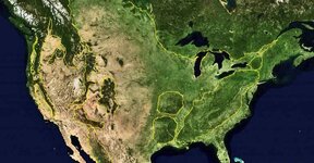
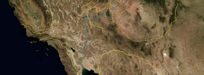
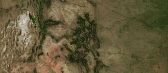
Here are some satellite views to illustrate the "flood plains" of the U.S. as seen from several hundred miles up. I've marked some, but not all. You can see the routes taken by the flood waters into the Gulf of Mexico and the Gulf of California.

Capture2-11-2011-12.31.25 AM.jpg


The blue line work is the Colorado River complex.

Capture2-11-2011-10.44.40 PM.jpg

Capture2-11-2011-10.44.06 PM.jpg
 

OP
OP
Shortstack

Shortstack

Silver Member
Jan 22, 2007
4,305
416
Detector(s) used
Tesoro Bandido II and DeLeon. also a Detector Pro Headhunter Diver, and a Garrett BFO called The Hunter & a Garrett Ace 250.
Primary Interest:
All Treasure Hunting
;D Yeah, and glaciers don't melt THAT fast. Actually, no were near fast enough to produce the kind of water flow as produced these flood plains.
 

OP
OP
Shortstack

Shortstack

Silver Member
Jan 22, 2007
4,305
416
Detector(s) used
Tesoro Bandido II and DeLeon. also a Detector Pro Headhunter Diver, and a Garrett BFO called The Hunter & a Garrett Ace 250.
Primary Interest:
All Treasure Hunting
There might have been an inland sea of good size before a great flood came along. These are just some variations on some theories. The concrete piece of evidence is that satellite photo. Those flood "footprints" didn't just pop up.

I just remembered something else. When I was stationed in Oklahoma, I learned that geologists label the Wichita Mountains as perhaps the oldest mountains on the North American Continent. Now, to my way of thinking; SOMETHING took them down in size and spread their dirt in a southerly direction. That took a lot of force to accomplish. The Wichita Mountains are actually FOOTHILLS now. Heck, the Stairsteps over in the far eastern part of the state have more elevation.

These are just part of some of the "surprising" things you find when you just look around and ask, "what the h--- caused THAT?" LOL
 

EE THr

Silver Member
Apr 21, 2008
3,979
38
Central California
Yeah, and then it depends on how far back you go, too. You can have the effects of something newer on top or adjoining something much older.

Then it can go back to when the continents were shaped differently. I wonder how much of the stuff that was on the surface back then is still on or near the surface now?
 

OP
OP
Shortstack

Shortstack

Silver Member
Jan 22, 2007
4,305
416
Detector(s) used
Tesoro Bandido II and DeLeon. also a Detector Pro Headhunter Diver, and a Garrett BFO called The Hunter & a Garrett Ace 250.
Primary Interest:
All Treasure Hunting
I can give a good example of buried stuff that hasn't been investigated too much. Do a little looking into Rockwall, Texas and how it got it's name.

Also, have you ever heard of the "river of gold"? That is a legendary ancient river that flowed north to south somewhere in the west and is the serious mother of all mothers of gold finds. Some believe the big gold strikes in California are parts of that river.

Death Valley is the deepest point (below sea level) in North America. What dug it out?? There's nothing special about that place to have caused the loss of so much overburden.

My favorite of all are the Great Lakes. Scientists claim that they were dug by glacier action. REALLY? Then why did those glaciers quit digging? And why didn't they start their "digging" further north? There are some very interesting geology in the Great Lakes area. Varying hard rock strata; especially in the Lake Superior region.

Then, there's the Carlsbad Caverns system. I don't think it has been FULLY explored to this day. Scientists say it "probably" was formed by volcanic action. Really?? What volcano was / is large enough to have done that?? And, then it disappeared?? There are remnants of volcanoes in the West, but none were big enough to have done that large of a lava tunnel. Are the caverns REALLY lava tunnels.

I have a book that is about 2 inches thick on the subject of unexplained "natural" phenomenons located all over the world and these just barely scratch the surface of this subject. What kind of geologic arrangement caused the development of The Devil's Post Pile? Geologists have all the great answers; BUT, are they correct? Leading physicists around the world were commenting right up until 1903, that there would NEVER be a heavier-than-air vehicle with the ability to sustain flight under it's own power. But, 2 bicycle mechanics from Dayton, Ohio proved them WRONG. And those 2 brothers had only high school educations. LOL THAT is my most favorite story of all.
 

EE THr

Silver Member
Apr 21, 2008
3,979
38
Central California
When the automobile was first being developed, they also claimed that if a person went faster than 25 mph in the open air, he wouldn't be able to breath! That was probably started by the horse breeders associations.

Don't lava tubes leave a lining of volcanic rock?
 

Springfield

Silver Member
Apr 19, 2003
2,850
1,383
New Mexico
Detector(s) used
BS
Shortstack said:
... Then, there's the Carlsbad Caverns system. I don't think it has been FULLY explored to this day. Scientists say it "probably" was formed by volcanic action. Really?? What volcano was / is large enough to have done that?? And, then it disappeared?? There are remnants of volcanoes in the West, but none were big enough to have done that large of a lava tunnel. Are the caverns REALLY lava tunnels. ....

TreasureNet Scientists, maybe. Carlsbad Caverns is a limestone structure, not volcanic. The caves were/are formed by weak solutions of carbonic acid (rainwater picking up CO2 from the surface soils/plants) gradually seeping into the fractured limestone below and dissolving same over time, forming voids.
 

OP
OP
Shortstack

Shortstack

Silver Member
Jan 22, 2007
4,305
416
Detector(s) used
Tesoro Bandido II and DeLeon. also a Detector Pro Headhunter Diver, and a Garrett BFO called The Hunter & a Garrett Ace 250.
Primary Interest:
All Treasure Hunting
Springfield said:
EE THr said:
... Don't lava tubes leave a lining of volcanic rock?

Yes.

Yep. Years ago, a friend and I explored the Sunset Crater National Park in northern Arizona and poked around some of the lava flow. One opening had a sign naming it an "ice cave".

There's a place called The Malapas (or something like that) that is a huge lava field. There's a couple of old treasure legends associated with the place. I forget whether it's in the Four Corners area or over in California. Thousands of lava caves there formed by lava tubes.

Springfield, you're probably right about that Carlsbad Caverns / lava / TNet "scientist" thing. LMAO A few years ago, I was doing some research in connection with the Roswell Incident and read some very interesting stories published in the local newspaper in the town of Carlsbad concerning the caverns and military activity on the backside of the park and how there were at least 2 different entrances, there, that were put off limits by the federal government. Some of the stories told of how MOST of the caverns were still unexplored and off limits to the general public. That was back in 1947. I was able to get access to an excellent newspaper archives that had those back copies of several New Mexico newspapers and the ones from Carlsbad held some very interesting stories. The kind of stories that the national wire services would have not bothered to put out to other papers. And for the record; the Roswell Incident DID happen, but it's not clear, yet, whether the crashed craft was one of OUR anti-grav vehicles (as brought back from Germany) or one of THEIR'S (he says while pointing toward the ceiling). LOL But, I don't want to get too much off of the subject of the Grand Canyon and it's secrets.........starting with that "sphinx.
 

Old Dog

Gold Member
May 22, 2007
5,860
397
Western Colorado
The Devil's Post Pile is a one of about two world wide that have been found examples of a rare phenom.
Picture a volcano that the crater filled up with magma, then cooled creating a solid core like what you see. and rather that the whole thing eroding down from the top the outside was worn away leaving the core standing as we see it today.

I believe the other example of this magnitude is in Chile.
That is a guess I could be wrong
 

OP
OP
Shortstack

Shortstack

Silver Member
Jan 22, 2007
4,305
416
Detector(s) used
Tesoro Bandido II and DeLeon. also a Detector Pro Headhunter Diver, and a Garrett BFO called The Hunter & a Garrett Ace 250.
Primary Interest:
All Treasure Hunting
Thanks, Thom. Seems like I read that explanation somewhere before, but my question is how can that produce a different kind of rock than the stuff I've seen at other volcanoes. I mean, lava cools to the same, porous, ugly brown rock. In Hawaii, the lava might be black because that's the color of the souvenir I bought several years ago. ;D The main point is that lava is a lot different than the native stone all over the world. :icon_scratch: It's a mystery.
 

Old Dog

Gold Member
May 22, 2007
5,860
397
Western Colorado
Bill that rock is Basalt,
Yes it is found all over the world.
This is a very pure form of it.
that is why it weathers at such a slow pace.
 

OP
OP
Shortstack

Shortstack

Silver Member
Jan 22, 2007
4,305
416
Detector(s) used
Tesoro Bandido II and DeLeon. also a Detector Pro Headhunter Diver, and a Garrett BFO called The Hunter & a Garrett Ace 250.
Primary Interest:
All Treasure Hunting
Guess the purity from NOT being exposed to the air (atmosphere) during the long term cooling is what made the difference. That must be why there are only 2 known locations. :thumbsup:
 

gord

Hero Member
Mar 30, 2005
529
41
London, ON
OP
OP
Shortstack

Shortstack

Silver Member
Jan 22, 2007
4,305
416
Detector(s) used
Tesoro Bandido II and DeLeon. also a Detector Pro Headhunter Diver, and a Garrett BFO called The Hunter & a Garrett Ace 250.
Primary Interest:
All Treasure Hunting
Thanks, gord, for this information. Those many-sided post shapes are now in the real oddity column that nature has made. (I almost said "God made", but that's too religious and would be deleted)

There are many things on earth that Earth Scientists have misidentified and refuse to "update" their ideas as to "how" they exist. Everything is the result of "volcanic action". ::)

The Grand Canyou Sphinx looks more artificial than natural. But, that is just my opinion and is why I started this thread. If more info about it and similar monuments can be brought out; it would be great.
 

EE THr

Silver Member
Apr 21, 2008
3,979
38
Central California
Shortstack---

Shortstack said:
The Grand Canyou Sphinx looks more artificial than natural.

An Aerial photograph would show if it's carved, or just a rock, on top of it.

But if it can no longer be found, maybe the Smithsonian has struck again.

:icon_scratch:
 

OP
OP
Shortstack

Shortstack

Silver Member
Jan 22, 2007
4,305
416
Detector(s) used
Tesoro Bandido II and DeLeon. also a Detector Pro Headhunter Diver, and a Garrett BFO called The Hunter & a Garrett Ace 250.
Primary Interest:
All Treasure Hunting
I've "flown" the Grand Canyon using Google Maps and bing Maps. I'll have to try several more times, because there are so many areas to peek at and during those "trips", I was also looking for any trails down in the Marble Canyon area.
 

Top Member Reactions

Users who are viewing this thread

Top