WHAT DOES THIS BOULDER REPRESENT? TRAIL MARKER? CAMPSITE MARKER?

MinerGirl

Sr. Member
Nov 17, 2011
298
148
meicigama
Detector(s) used
AT Pro
Primary Interest:
All Treasure Hunting
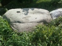
I posted this in Today's Finds but no responses yet. This Boulder is on a 10 acre property in Washtenaw County, Michigan. (Ann Arbor area)

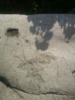
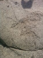
The Carving looks like either a Bird or Rabbit...maybe pointing towards a campsite? Also has a large grinding area and a carved out square. What is that for?

This boulder is just off U.S. 12 which is also called "The Great Saulk Trail"...(US 12 goes from Detroit to Chicago)...This boulder was found in the county and moved to this property many years ago...I couldn't find where it originally sat though..just know it was within this county.

Thanks for any replies...MinerGirl
 

Attachments

  • SSPX0522.jpg
    SSPX0522.jpg
    404.2 KB · Views: 192
  • SSPX0520.jpg
    SSPX0520.jpg
    395.7 KB · Views: 203
  • SSPX0519.jpg
    SSPX0519.jpg
    449.8 KB · Views: 223

dsty

Bronze Member
Dec 2, 2007
1,300
736
Randal County
For sure a important trail marker, usually a large marker indicates heavy load / carry lots of provisions / long distance / travel slow,Kim ( Desert Moon ) has a elephant on her site that is one of a kind as far as I know and possibly have the same meaning, the carved out square hole may indicate a diamond rather than a square and possibly measure by the league and will always have markers along the trail, I would first try to locate the original site and use that for a starting point, remember that a full body ( as oposed to a head only ) means that you have intersected the trail in the middle and can go in both directions
 

dsty

Bronze Member
Dec 2, 2007
1,300
736
Randal County
It is my belief that treasure hunting should be a enjoyable undertaking but as someone who enjoys basketball, football,tennis, golf and soforth I never got good at doing any of them so I started doing my best to to gather all the information I could about one and to share what I could understand with others. Thanks for the post MinerGirl, looking forward to more. I believe your trai marker is a Turtle
 

Last edited:

mdog

Bronze Member
Mar 22, 2011
2,325
4,377
Hi Minergirl,

The Sac Trail is a great place to look for trailmarkers. The French traders, explorers and Jesuit missionaries used it often starting in the 1600's. They also used trail markers just like anyone else. Dsty gives real good advice. You might be close to Fort St. Joseph which was close to an intersection of the Sac Trail and a major north-south trail.

Rick

Rick
 

OP
OP
M

MinerGirl

Sr. Member
Nov 17, 2011
298
148
meicigama
Detector(s) used
AT Pro
Primary Interest:
All Treasure Hunting
Thanks dsty and mdog, I look forward to all the info I can get...:) U.S. 12 intersects U.S. 127 just South of Jackson, MI and is the old North/South Route straight up to Mackinaw Bridge...Now we have US 75...but I prefer 127 when traveling North...(actually, I just read where it goes South all the way to Alabama!) Didn't know that..:) Another Old Indian Trail for sure.
 

desertmoons

Bronze Member
Apr 16, 2008
1,067
168
Minergirl... if there are some trails around there and clearly there are..just start walking where you might think it is. There are bound to be markers of one sort or another made by many groups and they are not all that far apart. I wonder if the Mormons on their way up there left their own marks. Keep an eye out for trail trees :) I am thinking perhaps a trail perhaps all the way up to the copper mines, though they would have to cross water? That would be exciting and opens up the range of time the trails could have been used.
 

OP
OP
M

MinerGirl

Sr. Member
Nov 17, 2011
298
148
meicigama
Detector(s) used
AT Pro
Primary Interest:
All Treasure Hunting
Thanks DesertMoon, sorry it took awhile to respond...Thats good advice and happy to know that if I find one carving, there will be others close by. This particular boulder came from another site and I've walked this whole property and haven't found anything related. Almost all the roads in my county are just paved over Indian Trails due to when the Colonials first started settling here they would get their wagons stuck in many marshy areas...It was fast advice to "Just take the Indian trails" as they were the best high ground routes. So its easier for us to find trail trees and knowing this area as I do it's fun to spot a Water Tree marker off in the distance and know there really is a water source there...

There is an old Copper mine in the Lower Peninsula (a couple hours southeast of the Mackinaw Bridge) The Bridge is a mile long (to the Upper Peninsula) so the Indians had alot of rowing but not out of the question I guess. I'll keep my eyes open for sure...Thanks again...MinerGirl
 

rangler

Bronze Member
Jul 12, 2004
1,320
200
The Land Of The Free Because Of The Brave!
Detector(s) used
for solutions to the jesuit code -email pics to: [email protected]


;[email protected] locations needed! oro bro!
Primary Interest:
Other
MinerGirl,
Desert Moons is correct - many old trails there, and perhaps the oldest of all -except native americans
is the Phoenicians..even though we are not sure if they accessed this area from the mississippi river or came thru the seaway...it has been proven that some of the copper artifacts found in Rome came from this area many moons [eons] ago..
keep hiking and have fun, take lots of pics and let us know what you find!
oro
rangler
 

OP
OP
M

MinerGirl

Sr. Member
Nov 17, 2011
298
148
meicigama
Detector(s) used
AT Pro
Primary Interest:
All Treasure Hunting
Hi Rangler,

Thanks for the info. I'll have to look up the Phoenicians. I didn't know our copper was found in Rome...Thats very interesting.

I posted this boulder in the pic awhile ago and since have read of similar boulders on another forum here. Someone described a boulder just like mine and said that it was meant to be a "seat" and one was to sit in the "seat" part of the boulder and "Look" in the direction that the "animal/bird" head is looking for the next sign.

So I think the right side of this boulder could really be a "seat" and Not a "Grinding area" for food...Just thought that was interesting.

Thanks for the info, gives me some things to look up and learn about.

MinerGirl
 

Last edited:

pops46

Jr. Member
Dec 6, 2011
35
0
Primary Interest:
Prospecting
Minergirl the area in the red box could be a map top line being a mountain/big hill lower line enlarge pic map.JPG being a river
 

OP
OP
M

MinerGirl

Sr. Member
Nov 17, 2011
298
148
meicigama
Detector(s) used
AT Pro
Primary Interest:
All Treasure Hunting
Pops46,

Thats really good info! This boulder was moved to this property and I thought I couldn't figure out where it originally sat until you just described the "Map"...The map as you describe is an exact description of the property where it Now sits. So I'm thinking this boulder was originally sitting 1/4 mile to the main road (Trail) and would have been on the Northwest corner to this (Trail/road)...If it was there, the bird would have been pointing up to this big Hill and it has a stream running through the bottom of this property....Its a 10 acre piece of land now with horses allowed etc but I didn't find much evidence of Stone Tools. 5 of these acres were under heavy brush and pasture land....Seems to be a Campsite marker to me...don't know.

Thanks for sharing...(I'll try to get someone to enlarge this pic..I'm not good at that yet...:( )

MinerGirl
 

pops46

Jr. Member
Dec 6, 2011
35
0
Primary Interest:
Prospecting
minergirl I'm glad that that helped. To enlarge click on the photo you can do this 3 times after seeing it click on the back button on your browser takes you back to the thread.
 

OP
OP
M

MinerGirl

Sr. Member
Nov 17, 2011
298
148
meicigama
Detector(s) used
AT Pro
Primary Interest:
All Treasure Hunting
Well, it did enlarge when I clicked on it...Very good detail and is as you described.

I just wonder what the square is that is "blacked out" (Upper left of the bird head)...it also shows some carved out circles...(Spread around the square, lower of the square and in direct line of the Bird-head feathers) would this indicate hidden "Stash Sites"?

Thanks...MinerGirl
 

pops46

Jr. Member
Dec 6, 2011
35
0
Primary Interest:
Prospecting
The square could represent the rock and the smaller ones a marker/stash. Did you notice the vase shadow in the lower right of the rock?
 

OP
OP
M

MinerGirl

Sr. Member
Nov 17, 2011
298
148
meicigama
Detector(s) used
AT Pro
Primary Interest:
All Treasure Hunting
Pops46...I was gone all day,

I see a "Face" under the "bird head"...and a "shadow" in the lower far right...don't know what that is though.

The Stash idea sounds fun...or maybe it marks the campsite and the other circles would be a stash round that campsite...Just guessing.

Thanks for the reply...This boulder is about 40 minutes from my house and now I think the house has an offer on it...not sure I can even get back there...

MinerGirl
 

Backbacon

Bronze Member
Sep 17, 2012
1,676
1,634
Da North Eh?
🥇 Banner finds
1
Detector(s) used
Garrett AT PRO
Primary Interest:
Metal Detecting
Looks like an old Native work table. The round hole is what I believe is a "nutting stone" which was used to hold nuts, clams, and other things one would want to smash open without messing up their fingers. The other grooves might be a tool forming, sharpening area (coarse and fine) in which to hone tools and points. If it's a map follow it!!! Try to put a transparent image of it over a google earth image of the area!!! I hope this helps you, best of luck EH.

Chris
 

Top Member Reactions

Users who are viewing this thread

Top