Just Drill Holes

Pinwheel

Sr. Member
Mar 9, 2012
307
223
Primary Interest:
Cache Hunting
Hello Pinwheel, I'll bet drill holes are to split a boulder

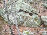
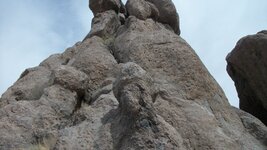
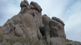
Hi dsty: I really don't think those holes were for splitting that bolder. I got back yesterday and got the measurements. These are different from any drill holes i have seen. They are drilled at a angle kind of like they were shot with a cannon ball on an angle. The holes are drilled in at about a 45* angle.Here is the measurements of the big one. It is 12" inches deep. It is 7" inches top to bottom. 14"inches side to side. From the long side to bottom is 17" The short side to the bottom is 8"inches.

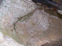
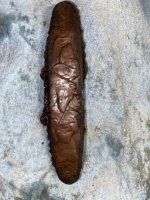
In Deep: There was a triangle in the bottom of the hole but I really could not see a map per say.

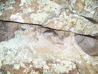
The second hole is shaped like a bird looking right. It is 8"inches deep. 7 1/2" side to side and 4 1/2"inches top to bottom.

april fools 203.JPG

The big hole
april fools 204.JPG

The triangle at the bottom
april fools 206.JPG

The small one.
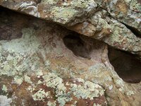
april fools 211.JPG


Pinwheel
 

Last edited:
OP
OP
D

dsty

Bronze Member
Dec 2, 2007
1,300
736
Randal County
Hello pinwheer, If we take a drill hole thats 8 inches deep divide by 4 = 2, and as a reference a 7,5 = ( should be a 6 or 8 ) looking at 8 inches divide by 4 = 2 so we take 2 + 2 = 4 inches deep X cordell 189.5 feet X 4 and I don't know about the 7 above the drill holes, if it really a 7 then it should be one of the directions, follow the long part of the 7 would be my guess. Heigth is very important on everything , if its the length and laying on top of the ground or the height up and down it does'nt seem to matter, It seems that if someone changed the depth/ width of the drill hole information would still be available. Its ok if no one wants to share the heigth of any the trail markers , monuments, corner markers. they come across.
 

Last edited:

Pinwheel

Sr. Member
Mar 9, 2012
307
223
Primary Interest:
Cache Hunting
Dsty. I didn't think to measure the height of This monument. Sorry. I will measure it the next time I am up there.

Oh yes. Thanks for your insight on this one.

Pinwheel
 

OP
OP
D

dsty

Bronze Member
Dec 2, 2007
1,300
736
Randal County
Thanks Pinwheel, It should be easier to determine what someone has if its a knee high ( 24 " ) cache site ( 189.5 feet Cordel ) Waist high 1/2 league,-- sholder high = league,--- 32 ft high profile = 7 leagues. On the years that I have been here and ask for mearsurement not one person has replied that I remember --- so the question remains unaswered, I believe it is important to know the distance and the direction before you put a extra sandwich or a extra bottle of water. Come-on folks , sometimes just a guess will help
 

OP
OP
D

dsty

Bronze Member
Dec 2, 2007
1,300
736
Randal County
Gotta friend that's interested in these drill holes, he figured that the square miles just in Oklahoma = over 14 thousand and divide that by 2.5 for a square league, it would still make a person hook up to just look at them all and plus he has a program on channel 13 and is interested in using the drill hole aspect as a feature, we started yesterday. plans are to get the different corner markers worked out photos, measurements, distance,, degrees and all that stuff, we plan too use it a historical learning tool, Gonna be fun
 

OP
OP
D

dsty

Bronze Member
Dec 2, 2007
1,300
736
Randal County
This is just my opinion and it seems to work in the field, The different measurements for a pace / vara / from 29 to 36 or what ever they are may not represent those years / area and so forth may indicate what you are looking for roads along and near the river and probably other places a road may have a 30 inch for its measurement in paces and the drill hole that represents a road will have a flat bottom ( who would have thought that ) a Royal Trail will have different vara measurement, a settlers square league will have a 33 inch measurement vara the measurement between vaults haven't been determined, from the vault ( main Bank ) to a Branch Bank ( square League ) can and will be measured and determined later, they seem to have a the area around the rivers sectioned off as being State land and anyone can use it. Just having a blast, The roads follow the easies route and they were marked with drill holes with flat bottoms, seem to indicate there will Not be any Symbols, Carvings, or Markings between those type of carvings,, got to do it your self, the smaller ones used in other situation's have the same meaning, The word that I was looking for was easement from the River to the road area along where it will be out of the flood zone.
 

Last edited:
OP
OP
D

dsty

Bronze Member
Dec 2, 2007
1,300
736
Randal County
Well this is what I think about a cylinder shape drill hole 12 inched deep 12 inches wide, straight sides and flat bottom with a smaller drill hole ( 3" X 2" ) on top, The circumference is 35 inches, 12 " across and 12' deep = 2 X 35 = 70 and 12 inches across the bottom and 12 inches from the bottom to the top = 2 X 70 = 140 cordel X 189.5 feet = 26530 divide by 5280 = 5.0246212, miles. I believe that it is a Royal Trail because I used a 33 inch and their method may have been a Soldiers pace or 66 inch and because the trail is across the river from the IN trail which is West and this one is East and Lacking all of the standard symbols and the length between and it would fit because what the cargo may have been Some one else can figure it using a 66 inch pace if you want to, my brain is almost gone. -----. Thanks For the help with the math
 

Last edited:
OP
OP
D

dsty

Bronze Member
Dec 2, 2007
1,300
736
Randal County
Does anyone else have any thoughts about these drill holes or symbol method of travel on a Royal Trail. Thanks
 

widomanmx

Banned
Dec 6, 2013
300
97
Chihuahua (mx)
Detector(s) used
Gemini 3
Deepers
Primary Interest:
Cache Hunting
dsty, i have not traveled spanish trails, but, maybe follow only heads its enough, so, you do not have to stop looking for drill-holes.

When an animal head look to sky and is resting over the ground, a place is close:
View attachment 1110968 View attachment 1110969
.. head points to the place
.. head only is visible from certain direction of the road and if you riding a horse

At the place you will find other head/s:
View attachment 1110977
.. probably rock-base height indicate some type of distance like you suggest

Some drill-holes (shape like a pool) can be related to water ??
 

Last edited:

widomanmx

Banned
Dec 6, 2013
300
97
Chihuahua (mx)
Detector(s) used
Gemini 3
Deepers
Primary Interest:
Cache Hunting
dsty, my idea about travel this Trails is following heads.

Distance to travel is relative and based on leagues .. like some users suggest, maybe a day basis.
Roads were very irregular with hills, downs, streams, etc.
People used horses or other similar animal to haul things and have a "easy" trip.
.. that would explain the irregularity of the measure (league)

Because Royal Trail its related to King and/or government workers,
the horse is the key .. i dont think they travel on "fast" donkeys.

Two options:
a) Head position in relation to the height of the horse: middle, below, level or above .. 1/2, 1/8?
b) Proportion of the head with his rock base. If head touch earth you are close (<500mt = 1/8-1/10? league)
.. no stops to look for drill holes, unless they needed water .. but that dont explain why some drill holes are "hidden"

IMHO
 

OP
OP
D

dsty

Bronze Member
Dec 2, 2007
1,300
736
Randal County
I believe that there may be several thoughts of all types of symbols and all markers drill holes, start of a trail symbol, if we take a drill hole, if it has a flat bottom and straight sides it seems to indicate a different measurement as one that has a sharp pointed bottom, I don't really know for sure but if I was on a trail that had a snake head I believe I would expect to find / danger / winding type of trail, or both, My opinion might be that a head that looked to the sky I might consider that it might be a long trail as you might expect an arrow to travel when you point your bow toward the sky would have a longer distance. I also believe that the difference in travel and cordell's vs leagues may depend on the type of trail you are on. Anyway experience is the teacher. Thanks
 

Rebel - KGC

Gold Member
Jun 15, 2007
21,680
14,739
I have Drill Holes on boulders in the Mountains of VIRGINIA... reckon they are Sighting Pole Holes for surveying... dunno.
 

OP
OP
D

dsty

Bronze Member
Dec 2, 2007
1,300
736
Randal County
Viking Moring Holes, I think was used to show the distance and direction that you should go, there maybe as many as 2 / 3 hundred styles and types, Note the Masons also was well versed in their uses, George Washing was a noted Mason also.
 

Rawhide

Silver Member
Nov 17, 2010
3,590
2,185
SouthWestern USA
Detector(s) used
Nox 800, Etrac, F75, AT Pro. Last two for sale.
Primary Interest:
All Treasure Hunting
I always thought drill holes cold be used for two things. Either marking a target by putting a measured stick in them. Or part of a rock map.
381978_4618630465434_1608606919_n.jpg 537974_4618634585537_678294135_n.jpg

Always thought the one rock here looked like a half buried heart. It has what appears to be many drill holes.
 

Top Member Reactions

Users who are viewing this thread

Top