Desert Tracks: Ancient or Modern

DesertRat

Jr. Member
Jun 12, 2006
37
4
Detector(s) used
Tesero Lobo Super Traq
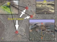
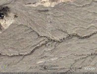
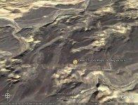
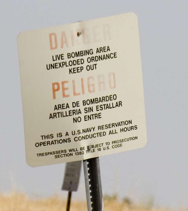
These desert tracks lead from a small elevated dune at the foot of the eastern edge of the Fish Creek Mountains north to south, over washes, and small hills. Sometimes they disappear and then reappear. Out of curiosity I followed them using Google Earth. They look like modern tracks used by some government vehicles. Funny thing is where they lead to and where they stop. Using the measuring tool on Google, the tracks run straight for almost six miles before abruptly turning a perfect ninety degrees and stopping at an incongruous location. Measured distance 6.66 miles. I know its just a number. What I would like to find out is who made the tracks and why. The end locations seem to indicate something of value was hidden and dug up. Those of you who have Google the coordinates are: 32 deg. 56' 07.11"N 115 deg. 59' 03.47" W. Any ideas out there?
 

Attachments

  • Desert tracks.jpg
    Desert tracks.jpg
    71.9 KB · Views: 1,097
  • Desert Tracks - ninety degree turn.jpg
    Desert Tracks - ninety degree turn.jpg
    95.2 KB · Views: 1,083

point hunter

Full Member
Feb 1, 2007
148
82
West Monroe, Louisiana
Detector(s) used
Ace 250, GTI 2500
Hi. Are you close to this area? I would get on the ground and check it closer. The point of the V has two smaller white lines that could possibly be directional in nature. Just past the point in the dark circular spot which might provide some other clues. The entire larger V ends to suddenly on both sides. I'm not convinced it's modern.
 

R

Rich

Guest
It might be a Overlay problem of layering mapping,...but im gonna check it out on GEarth,it does look abit strange!!
 

starsplitter

Sr. Member
Jan 20, 2007
434
31
Weird. Are there any operating bases in the neighborhood? Or, rumors of bases? Perhaps it is linked to some sort of government activity?
 

djui5

Bronze Member
May 22, 2006
1,807
293
Mesa, AZ
Detector(s) used
None
Primary Interest:
Prospecting
the GOV would be my first guess. Might not wanna find out where those tracks lead :o :o :o
 

gollum

Gold Member
Jan 2, 2006
6,729
7,596
Arizona Vagrant
Detector(s) used
Minelab SD2200D (Modded)/ Whites GMT 24k / Fisher FX-3 / Fisher Gold Bug II / Fisher Gemini / Schiebel MIMID / Falcon MD-20
Primary Interest:
All Treasure Hunting
Hey DR,

That's my stompin grounds too. That's about the weirdest thing I've seen. About 6.5 miles start to finish, and about 75 feet wide (average). Runs absolutely perfectly North-South and East-West.

I know South of the Park (Just North of the 8, there are a set of high power wires that run over to the power station. These aren't them.

I thought it might have been an off-road race course, but the way the tracks go over some pretty steep arroyos doesn't make a lot of sense either.

I don't think they are photo overlay issues, because if you closely follow the tracks start to finish, you can see where there is sand blown over part of them, and other smaller trails crossing them.

About the only thing left that I can think of are tank trails for desert maneuvers (Africa Training). Patton did more training East of 29 Palms than he did down there, and I haven't seen any trails like this up there. WEIRD WEIRD WEIRD

Best,

Mike
 

wolfpaw518

Full Member
Oct 15, 2006
119
0
Minnesota
Detector(s) used
Sharpshooter II
I do a lot of research on the WW-II battles in North Africa. I have scanned the desert there for remaining scars of tank combat (see below), still there after all these years, but I have never seen anything like this.

I don't think there vehicle tracks, to big and to straight, not to mention steep wadi's and shear cliffs without deviation. They could be older, earlier than the erosion that caused the terrain features.

What about the old Native works...what did they call them, the giant birds and symbols that could only be seen from the air? Could it be something like that?

TT78.JPG


Just a thought
neil
 

gollum

Gold Member
Jan 2, 2006
6,729
7,596
Arizona Vagrant
Detector(s) used
Minelab SD2200D (Modded)/ Whites GMT 24k / Fisher FX-3 / Fisher Gold Bug II / Fisher Gemini / Schiebel MIMID / Falcon MD-20
Primary Interest:
All Treasure Hunting
The good news is.......these tracks are outside Anza-Borrego Desert State Park! Metal Detectors are legal!

Best,

Mike
 

Monty

Gold Member
Jan 26, 2005
10,746
166
Sand Springs, OK
Detector(s) used
ACE 250, Garrett
Primary Interest:
All Treasure Hunting
The Air Force makes hundreds dry bomb runs over barren lands all over the southwest. Sometimes they will set up visual aids or even radar reflectors to identify practice sites. It wouldn't be unusual for them to set up a radar reflector and then come back and remove it later. That little knoll would be an ideal site to set up something of this nature. The perfectly square corner would also be an indicator of a visual aid for airborne maneuvers. I don't know this to be the answer to your puzzle, but I do know such things aren't unusual for the AF. They use to call the simulated nuclear bomb runs oil burner routes, but that was years ago, so I don't know what they are called now. Monty
 

gollum

Gold Member
Jan 2, 2006
6,729
7,596
Arizona Vagrant
Detector(s) used
Minelab SD2200D (Modded)/ Whites GMT 24k / Fisher FX-3 / Fisher Gold Bug II / Fisher Gemini / Schiebel MIMID / Falcon MD-20
Primary Interest:
All Treasure Hunting
Hey Monty,

Good idea. That thought crossed my mind as well, but this area is West and South of the Naval Bombardment Range. If they were lines used to set up bomb runs, they would lead to the bombardment range. They don't.

Also, there would be craters from the bombs dropped, like this area SouthWest of Area 51:

51avp3.jpg


I'm stymied!?!

Best,

Mike
 

Monty

Gold Member
Jan 26, 2005
10,746
166
Sand Springs, OK
Detector(s) used
ACE 250, Garrett
Primary Interest:
All Treasure Hunting
The bomb runs I am talking about they do not drop any ordinance, just practice runs only. They do a lot more dry runs than they do actual deliveries. Usually simulated nuke drops. And, the radar reflectors don't have to be anywhere near the bomb range. I was stationed on a bomb range for 18 months. Monty
 

S

Smee

Guest
If you look at the tracks as the end of an arrow (which is sometimes used as a waypoint marker on some flight training simulators) and follow it across the Mexican border, just past the mountain you will pass over, you will see some bomb craters. I believe there were 3 of them (on dialup here at home so I have to rely on memory).

Just to the left of the mountain, there is another "waypoint" similar to this one and pointed in the same direction.

Using the first waypoint, but reversing your direction, you will fly directly over an AFB (March AFB?) in California.

Just a thought you might want to check out
 

gollum

Gold Member
Jan 2, 2006
6,729
7,596
Arizona Vagrant
Detector(s) used
Minelab SD2200D (Modded)/ Whites GMT 24k / Fisher FX-3 / Fisher Gold Bug II / Fisher Gemini / Schiebel MIMID / Falcon MD-20
Primary Interest:
All Treasure Hunting
Hey Smee,

First, we would never invade Mexican Air Space, and drop bombs in another country (unless it had rich oil reserves). ESPECIALLY, when we had the CARRIZO NAVAL BOMBARDMENT RANGE about 6 miles to the East of the Northernmost end of the tracks. They still use it today. You can watch as A6's make bomb runs overhead.

impactareaya9.jpg


Best,

Mike
 

S

Smee

Guest
gollum said:
First, we would never invade Mexican Air Space, and drop bombs in another country (unless it had rich oil reserves). ESPECIALLY, when we had the CARRIZO NAVAL BOMBARDMENT RANGE about 6 miles to the East of the Northernmost end of the tracks.

So true, however the waypoint would not show you the direction to travel, but rather be the location to take your NEXT heading . . . unless you forgot and "missed your mark". ::)

I am not at my PC, but in a bit, I'll see if I can get the pic. All of this looks pretty old, probably predating Vietnam --- and possibly as far back as WWII. But, that is just my opinion which everyone knows is like a bellybutton --- we all got one.
 

Monty

Gold Member
Jan 26, 2005
10,746
166
Sand Springs, OK
Detector(s) used
ACE 250, Garrett
Primary Interest:
All Treasure Hunting
I think you are exactly right smee. The weigh point you refer to I think they call it the IP or Initial Point, it's a beacon to take their next heading. When I was stationed on the bombing range, they would call, "IP" when they had a fix on the point in question and when they released their bomb they would call, "bingo" so we could start looking for the splash if they wre carrying a bomb. If it wasn't a dry run they would release a "shape" that is the same size and weight as a nuclear bomb only it's filled with concrete. It weighed about 2,000 lb. and it would leave a sizeable crater even though inert. Anything within 15,000 ft. was considered a direct hit with a real nuclear bomb. And sometimes the U.S. does contract with other countries to use barren land for simulated bombing runs. The range I was on was outside the U. S. Monty
 

S

Smee

Guest
Personally, I would like it to be an ancient wall or something else of ancient origins . . . that would be really neat!

Look forward to hearing what you find . . . just keep the rattlesnake stories to yourself  ;D
 

Monty

Gold Member
Jan 26, 2005
10,746
166
Sand Springs, OK
Detector(s) used
ACE 250, Garrett
Primary Interest:
All Treasure Hunting
I also hope it's something ancient, but I am just a little skeptical that no one has found it before now. That right angle could actually be a "V" as IPs were often indicated as a "V". I would love to go exploring with you if I could. When you do get a chance to go check it out be sure to let us know what you find. Monty
 

gollum

Gold Member
Jan 2, 2006
6,729
7,596
Arizona Vagrant
Detector(s) used
Minelab SD2200D (Modded)/ Whites GMT 24k / Fisher FX-3 / Fisher Gold Bug II / Fisher Gemini / Schiebel MIMID / Falcon MD-20
Primary Interest:
All Treasure Hunting
Hey Rat,

I don't think it would go to Carrizo Bomb Range. Most likely to be annexed into Anza-Borrego Desert State Park.

Best,

Mike
 

Top Member Reactions

Users who are viewing this thread

Top